FCCInfo.com
A Service of Cavell, Mertz & Associates, Inc.
(855) FCC-INFO
|
|
KCSO-LP from 06/12/1998 K60ES from 03/26/1992 891208ZB from ??? |
Virtual Channel 33 |
|
||||||||||||||||||||||||||||
|
|
Status: STA – Special Temporary Authority Application Accepted: 02/28/2019 STA Expires: 12/01/2030 File Number: 0000068166 FCC Website Links: LMS Facility Details This Application Other KCSO-LD Applications Including Superseded Applications Service Contour - Open Street Map or USGS Map (43 dBu) Service Contour - KML / Google Earth (43 dBu) Rabbit Ears Info Search for KCSO-LD Site Location: 38-16-18.0 N 121-30-22.0 W (NAD 83) Site Location: 38-16-18.3 N 121-30-18.2 W (Converted to NAD 27) ERP: 3 kW Polarization: Horizontally polarized R/C AGL: 518 m (1699 ft.) R/C AMSL: 518.6 m (1701 ft.) Emission Mask: Full Service Site Elevation: 0.6 m. (2 ft.) Height Overall*: 608.7 m (1997 ft.) (* As Filed In This Application, may differ from ASR Data, Below.) Directional Antenna - Antenna Make/Model: Jampro JCPD-1/2(2)V Antenna ID: 106417 Polarization: Horizontally polarized | ||||||||||||||||||||||||||||||
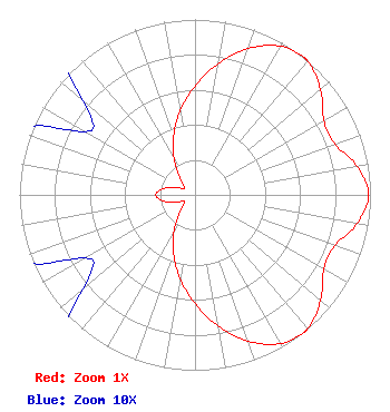
| Antenna Data for Antenna Id: 106417 KCSO-LD LD File: -0000068166 Jampro - JCPD-1/2(2)V Service: LD Standard Pattern: Y Pattern and Field Values Include a 180° Clockwise Rotation |  | ||||||||||||||||||||||||||||||
| Azimuth | Ratio | Azimuth | Ratio | Azimuth | Ratio | Azimuth | Ratio | ||||||||||||||||||||||||
| 0 | 0.620 | 10 | 0.759 | 20 | 0.888 | 30 | 0.978 | ||||||||||||||||||||||||
| 37 | 1.000 | 40 | 0.997 | 50 | 0.934 | 60 | 0.848 | ||||||||||||||||||||||||
| 70 | 0.848 | 80 | 0.938 | 90 | 0.990 | 100 | 0.938 | ||||||||||||||||||||||||
| 110 | 0.848 | 120 | 0.848 | 130 | 0.934 | 140 | 0.997 | ||||||||||||||||||||||||
| 143 | 1.000 | 150 | 0.978 | 160 | 0.888 | 170 | 0.759 | ||||||||||||||||||||||||
| 180 | 0.620 | 190 | 0.485 | 200 | 0.358 | 210 | 0.240 | ||||||||||||||||||||||||
| 220 | 0.142 | 230 | 0.083 | 240 | 0.072 | 250 | 0.122 | ||||||||||||||||||||||||
| 260 | 0.191 | 270 | 0.223 | 280 | 0.191 | 290 | 0.122 | ||||||||||||||||||||||||
| 300 | 0.072 | 310 | 0.083 | 320 | 0.142 | 330 | 0.240 | ||||||||||||||||||||||||
| 340 | 0.358 | 350 | 0.485 | ||||||||||||||||||||||||||||
Structure Registration Number 1012278 Structure Type: TOWER Registered To: Tribune Media Company Structure Address: 1400 Twin Cities Rd Walnut Grove, CA County Name: Sacramento County ASR Issued: 01/16/2020 Date Built: 09/20/1985 Site Elevation: 0.6 m (2 ft.) Structure Height: 591.3 m (1940 ft.) Height Overall: 608.7 m (1997 ft.) Overall Height AMSL: 609.3 m (1999 ft.) FAA Study #: 82-AWP-1123-OE Paint & Light FAA Chapters: A1, B, G, H, 3, 10.2, 19.2, 21, 23 DUAL HIGH INTENSITY 38-16-18.0 N 121-30-22.0 W (NAD 83) 38-16-18.3 N 121-30-18.2 W (Converted to NAD 27) |
300 New Jersey Avenue, NW Suite 700 Washington, DC 20001 Phone: 202-524-6401 Limited Liability Company | Title: Chief Engineer Date: 02/28/2019 Application Certifier Serestar Communications Corporation Serestar Communications Corporation PO Box: 2630 Rancho Santa Fe, CA 92067 Applicant Paul W. Johnson W. Johnson Serestar Communications Corporation 500 Media Place Sacramento, CA 95815 Esq. Gregg P Skall P Skall, Esq. Womble Carlyle Sandridge & Rice, LLP 1200 19th Street, N.W Suite 500 Washington, DC 20036 Louis R Dutreil, Jr Dutreil Lundin & Rackley Inc 201 Fletcher Ave Sarasota, FL 34237 Technical Consultant | |||||||||||||||||||||||||||||
| |||||||||||||||||||||||||||||||