FCCInfo.com
A Service of Cavell, Mertz & Associates, Inc.
(855) FCC-INFO
|
|
961001KQ from ??? |
Virtual Channel 46 |
|
||||||||||||||||||
|
|
Status: LIC Application Accepted: 04/19/2019 License Expires: 06/01/2030 File Number: 0000072046 FCC Website Links: LMS Facility Details This Application Other KOCM Applications Including Superseded Applications Service Contour - Open Street Map or USGS Map (41 dBu) Service Contour - KML / Google Earth (41 dBu) Public Inspection Files Rabbit Ears Info Search for KOCM Site Location: 35-33-36.9 N 97-29-07.6 W (NAD 83) Site Location: 35-33-36.7 N 97-29-06.5 W (Converted to NAD 27) ERP: 27 kW Polarization: Elliptically polarized HAAT: 416 m (1365 ft.) Electrical Beam Tilt: 0.75 degrees R/C AGL: 479 m (1572 ft.) R/C AMSL: 828 m (2717 ft.) Site Elevation: 349 m. (1145 ft.) Height Overall*: 489 m (1604 ft.) (* As Filed In This Application, may differ from ASR Data, Below.) Directional Antenna - Antenna Make/Model: R.F. Systems PEPL56D-VPT-0-2-7 Antenna ID: 1004924 Polarization: Elliptically polarized | ||||||||||||||||||||
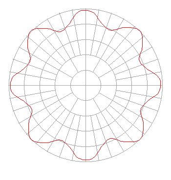
| Antenna Data for Antenna Id: 1004924 KOCM DT File: -0000072046 R.F. Systems - PEPL56D-VPT-0-2-7 Service: DT Standard Pattern: N Pattern and Field Values Include a 5° Clockwise Rotation |  | ||||||||||||||||||||
| Azimuth | Ratio | Azimuth | Ratio | Azimuth | Ratio | Azimuth | Ratio | ||||||||||||||
| 5 | 0.959 | 15 | 0.829 | 25 | 0.791 | 35 | 0.921 | ||||||||||||||
| 45 | 1.000 | 55 | 0.903 | 65 | 0.769 | 75 | 0.827 | ||||||||||||||
| 85 | 0.963 | 95 | 0.959 | 105 | 0.829 | 115 | 0.791 | ||||||||||||||
| 125 | 0.921 | 135 | 1.000 | 145 | 0.903 | 155 | 0.769 | ||||||||||||||
| 165 | 0.827 | 175 | 0.963 | 185 | 0.959 | 195 | 0.829 | ||||||||||||||
| 205 | 0.791 | 215 | 0.921 | 225 | 1.000 | 235 | 0.903 | ||||||||||||||
| 245 | 0.769 | 255 | 0.827 | 265 | 0.963 | 275 | 0.959 | ||||||||||||||
| 285 | 0.829 | 295 | 0.791 | 305 | 0.921 | 315 | 1.000 | ||||||||||||||
| 325 | 0.903 | 335 | 0.769 | 345 | 0.827 | 355 | 0.963 | ||||||||||||||
Structure Registration Number 1253490 Structure Type: GTOWER Registered To: American Towers LLC Structure Address: 1501 Ne 85th St Oklahoma City, OK County Name: Oklahoma County ASR Issued: 03/08/2017 Date Built: 06/21/2007 Site Elevation: 349 m (1145 ft.) Structure Height: 489 m (1604 ft.) Height Overall: 489 m (1604 ft.) Overall Height AMSL: 838 m (2749 ft.) FAA Determination: 03/02/2017 FAA Study #: 2015-ASW-1665-OE Paint & Light FAA Chapters: B, F, H, 3, 10, 19, 21, 23 Continue As Is OM&L = A HIGH-DUAL SYSTEM 35-33-36.9 N 97-29-07.6 W (NAD 83) 35-33-36.7 N 97-29-06.5 W (Converted to NAD 27) |
3901 Highway 121 South Bedford, TX 76021 Phone: 817-571-1229 Not-for-Profit | Title: President Date: 04/19/2019 Application Certifier Word of God Fellowship, Inc. Word of God Fellowship, Inc. 3901 Highway 121 South Bedford, TX 76021 Applicant Richard C Goetz RL Mediasystems 135 N Country Club Dr Hendersonville, TN 37075 Broadcast Consultant | |||||||||||||||||||