FCCInfo.com
A Service of Cavell, Mertz & Associates, Inc.
(855) FCC-INFO
|
|
WQIZ-LP from 08/22/2019 W33BW from 02/12/1999 W59BP from 02/12/1999 821124SA from ??? |
|
|
||||||||||||||||
|
|
Status: STA – Special Temporary Authority Application Accepted: 07/17/2019 STA Expires: 10/01/2029 File Number: 0000078219 FCC Website Links: LMS Facility Details This Application Other WQIZ-LD Applications Including Superseded Applications Service Contour - Open Street Map or USGS Map (74 dBu) Service Contour - KML / Google Earth (74 dBu) Rabbit Ears Info Search for WQIZ-LD Site Location: 40-44-50.2 N 82-18-53.6 W (NAD 83) Site Location: 40-44-50.0 N 82-18-54.0 W (Converted to NAD 27) ERP: 15 kW Polarization: Horizontally polarized Electrical Beam Tilt: .75 degrees R/C AGL: 148.4 m (487 ft.) R/C AMSL: 550.7 m (1807 ft.) Site Elevation: 402.3 m. (1320 ft.) Height Overall*: 152.4 m (500 ft.) (* As Filed In This Application, may differ from ASR Data, Below.) Directional Antenna - Antenna Make/Model: Jampro JA/LS-BC-12 Antenna ID: 39928 Polarization: Horizontally polarized | ||||||||||||||||||
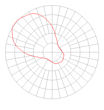
| Antenna Data for Antenna Id: 39928 WQIZ-LD TX File: -0000078219 Jampro - JA/LS-BC-12 Service: TX Standard Pattern: Y Pattern and Field Values Include a 313° Clockwise Rotation |  | ||||||||||||||||||
| Azimuth | Ratio | Azimuth | Ratio | Azimuth | Ratio | Azimuth | Ratio | ||||||||||||
| 3 | 0.500 | 13 | 0.350 | 23 | 0.270 | 33 | 0.220 | ||||||||||||
| 43 | 0.190 | 53 | 0.180 | 63 | 0.180 | 73 | 0.190 | ||||||||||||
| 83 | 0.210 | 93 | 0.230 | 103 | 0.260 | 113 | 0.270 | ||||||||||||
| 123 | 0.280 | 133 | 0.290 | 143 | 0.280 | 153 | 0.270 | ||||||||||||
| 163 | 0.260 | 173 | 0.230 | 183 | 0.210 | 193 | 0.190 | ||||||||||||
| 203 | 0.180 | 213 | 0.180 | 223 | 0.190 | 233 | 0.220 | ||||||||||||
| 243 | 0.270 | 253 | 0.350 | 263 | 0.500 | 273 | 0.660 | ||||||||||||
| 283 | 0.820 | 293 | 0.920 | 303 | 1.000 | 313 | 1.000 | ||||||||||||
| 323 | 0.960 | 333 | 0.920 | 343 | 0.820 | 353 | 0.660 | ||||||||||||
Structure Registration Number 1227797 Structure Type: TOWER Registered To: CHRISTIAN BROADCASTING MINISTRY Structure Address: East Side Of State Route 511 Widowville, OH County Name: Ashland County ASR Issued: 07/24/2001 Date Built: 11/18/2001 Site Elevation: 402.3 m (1320 ft.) Structure Height: 151.5 m (497 ft.) Height Overall: 152.4 m (500 ft.) Overall Height AMSL: 554.7 m (1820 ft.) FAA Determination: 06/28/2001 FAA Study #: 01-AGL-3472-OE FAA Circular #: 70/7460-1K Paint & Light FAA Chapters: 3, 4, 5, 12 40-44-50.2 N 82-18-53.6 W (NAD 83) 40-44-50.0 N 82-18-54.0 W (Converted to NAD 27) |
1282 North Main St. Marion, OH 43302 Phone: 740-383-1794 Corporation | Title: Vice President Date: 07/17/2019 Application Certifier Christian Faith Broadcast, Inc. Christian Faith Broadcast, Inc. 3809 Maple Avenue Castalia, OH 44824 Applicant Esq. Kathleen Victory Victory, Esq. Fletcher Heald & Hildreth, PLC 1300 17th St. N 11th Floor Arlingtn, VA 22209 | |||||||||||||||||