FCCInfo.com
A Service of Cavell, Mertz & Associates, Inc.
(855) FCC-INFO
|
|
WKAF from 07/06/1982 791022KE from ??? |
Virtual Channel 68 |  |
|
||||||||||||||||||||||||
|
|
Status: LIC Application Accepted: 08/01/2019 License Expires: 06/01/2031 File Number: 0000079843 FCC Website Links: LMS Facility Details This Application Other WSYT Applications Including Superseded Applications Service Contour - Open Street Map or USGS Map (41 dBu) Service Contour - KML / Google Earth (41 dBu) Public Inspection Files Rabbit Ears Info Search for WSYT Site Location: 42-52-50.2 N 76-11-58.7 W (NAD 83) Site Location: 42-52-50.0 N 76-11-60.0 W (Converted to NAD 27) ERP: 540 kW Polarization: Elliptically polarized HAAT: 415.1 m (1362 ft.) Electrical Beam Tilt: 0.75 degrees R/C AGL: 274.3 m (900 ft.) R/C AMSL: 771.1 m (2530 ft.) Site Elevation: 496.8 m. (1630 ft.) Height Overall*: 310.6 m (1019 ft.) (* As Filed In This Application, may differ from ASR Data, Below.) Directional Antenna - Antenna Make/Model: DIELECTRIC TFU-18DSC/VP-R T140 DC Antenna ID: 1005331 Polarization: Elliptically polarized | |||||||||||||||||||||||||||
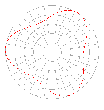
| Antenna Data for Antenna Id: 1005331 WSYT DX File: -0000079843 DIELECTRIC - TFU-18DSC/VP-R T140 DC Service: DX Standard Pattern: N |  | |||||||||||||||||||||||||||
| Azimuth | Ratio | Azimuth | Ratio | Azimuth | Ratio | Azimuth | Ratio | |||||||||||||||||||||
| 0 | 0.779 | 10 | 0.865 | 20 | 0.946 | 30 | 0.994 | |||||||||||||||||||||
| 35 | 1.000 | 40 | 0.994 | 50 | 0.946 | 60 | 0.865 | |||||||||||||||||||||
| 70 | 0.779 | 80 | 0.710 | 90 | 0.675 | 100 | 0.675 | |||||||||||||||||||||
| 110 | 0.710 | 120 | 0.779 | 130 | 0.865 | 140 | 0.946 | |||||||||||||||||||||
| 150 | 0.994 | 155 | 1.000 | 160 | 0.994 | 170 | 0.946 | |||||||||||||||||||||
| 180 | 0.865 | 190 | 0.779 | 200 | 0.710 | 210 | 0.675 | |||||||||||||||||||||
| 220 | 0.675 | 230 | 0.710 | 240 | 0.779 | 250 | 0.865 | |||||||||||||||||||||
| 260 | 0.946 | 270 | 0.994 | 275 | 1.000 | 280 | 0.994 | |||||||||||||||||||||
| 290 | 0.946 | 300 | 0.865 | 310 | 0.779 | 320 | 0.710 | |||||||||||||||||||||
| 330 | 0.675 | 340 | 0.675 | 350 | 0.710 | |||||||||||||||||||||||
Structure Registration Number 1006348 Structure Type: TOWER Registered To: Sinclair Properties, LLC Structure Address: Barker Rd Off Kingsley Rd Otisco, NY County Name: Onondaga County ASR Issued: 04/25/2002 Date Built: 03/20/1987 Site Elevation: 496.8 m (1630 ft.) Structure Height: 299.9 m (984 ft.) Height Overall: 310.6 m (1019 ft.) Overall Height AMSL: 807.4 m (2649 ft.) FAA Determination: 07/16/1999 FAA Study #: 99-AEA-1505-OE FAA Circular #: 70/7460-1J Paint & Light FAA Chapters: 4, 9, 13 PRIOR FAA 84-AEA-0893-OE 42-52-50.2 N 76-11-58.7 W (NAD 83) 42-52-50.0 N 76-11-60.0 W (Converted to NAD 27) |
87 St. Andrews Jackson, MS 39211 Phone: 601-954-3176 Limited Liability Company | Title: Chief Technology Officer Date: 08/01/2019 Application Certifier Bristlecone Broadcasting LLC 2111 University Park Drive Suite 650 Okemos, MI 48864 Applicant Dennis P Corbett Telecommunications Law Professionals PLLC 1025 Connecticut Avenue NW Suite 1011 Washington, DC 20036 Joseph M. Davis, P.E. Chesapeake RF Consultants, LLC 207 Old Dominion Road Yorktown, VA 23692 Consulting Engineer Catalin O Popescu, P.E. Northwest Broadcasting, Inc. 1000 James Street Syracuse, NY 13203 Director of Engineering Ron Sweatte Northwest Broadcasting, Inc. 2111 University Park Drive Suit 600 Okemos, MI 48864 Chief Technology Officer | ||||||||||||||||||||||||||
|
| |||||||||||||||||||||||||||