FCCInfo.com
A Service of Cavell, Mertz & Associates, Inc.
(855) FCC-INFO
|
|
960126KE from 01/26/1996 |
Virtual Channel 30 |  |
|
|||||||||||||||||
|
|
Status: LIC Application Accepted: 08/12/2019 License Expires: 06/01/2031 File Number: 0000080258 FCC Website Links: LMS Facility Details This Application Other WSKA Applications Including Superseded Applications Service Contour - Open Street Map or USGS Map (41 dBu) Service Contour - KML / Google Earth (41 dBu) Public Inspection Files Rabbit Ears Info Search for WSKA Site Location: 42-08-31.2 N 77-04-38.8 W (NAD 83) Site Location: 42-08-30.9 N 77-04-39.9 W (Converted to NAD 27) ERP: 50 kW Polarization: Horizontally polarized HAAT: 334 m (1096 ft.) Electrical Beam Tilt: 0.8 degrees R/C AGL: 236 m (774 ft.) R/C AMSL: 748 m (2454 ft.) Emission Mask: Simple Site Elevation: 512 m. (1680 ft.) Height Overall*: 244 m (801 ft.) (* As Filed In This Application, may differ from ASR Data, Below.) Directional Antenna - Antenna Make/Model: DIELECTRIC TUA-C4SP-8/28M-1-T Antenna ID: 1005386 Polarization: Horizontally polarized | ||||||||||||||||||||
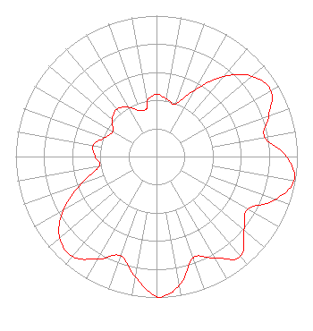
| Antenna Data for Antenna Id: 1005386 WSKA DT File: -0000080258 DIELECTRIC - TUA-C4SP-8/28M-1-T Service: DT Standard Pattern: N |  | ||||||||||||||||||||
| Azimuth | Ratio | Azimuth | Ratio | Azimuth | Ratio | Azimuth | Ratio | ||||||||||||||
| 0 | 0.443 | 10 | 0.414 | 20 | 0.398 | 30 | 0.547 | ||||||||||||||
| 40 | 0.743 | 50 | 0.886 | 60 | 0.938 | 70 | 0.848 | ||||||||||||||
| 80 | 0.779 | 90 | 0.925 | 100 | 0.992 | 110 | 0.895 | ||||||||||||||
| 120 | 0.748 | 130 | 0.812 | 140 | 0.927 | 150 | 0.831 | ||||||||||||||
| 160 | 0.764 | 170 | 0.928 | 178 | 1.000 | 180 | 0.994 | ||||||||||||||
| 190 | 0.867 | 200 | 0.749 | 210 | 0.841 | 220 | 0.927 | ||||||||||||||
| 230 | 0.898 | 240 | 0.766 | 250 | 0.572 | 260 | 0.413 | ||||||||||||||
| 270 | 0.435 | 280 | 0.457 | 290 | 0.391 | 300 | 0.359 | ||||||||||||||
| 310 | 0.411 | 320 | 0.439 | 330 | 0.404 | 340 | 0.347 | ||||||||||||||
| 349 | 0.347 | 350 | 0.401 | ||||||||||||||||||
Structure Registration Number 1250909 Structure Type: TOWER Registered To: T & K Communications Inc. Structure Address: Keegan Road, Higman Hill Corning, NY County Name: Steuben County ASR Issued: 11/14/2024 Site Elevation: 512 m (1680 ft.) Structure Height: 244 m (801 ft.) Height Overall: 244 m (801 ft.) Overall Height AMSL: 756 m (2480 ft.) FAA Determination: 09/30/2005 FAA Study #: 2004-AEA-2313-OE FAA Circular #: 70/7460-1K Paint & Light FAA Chapters: 3, 4, 5, 12 PRIOR STUDY 1997-AEA-3830-OE 42-08-31.2 N 77-04-38.8 W (NAD 83) 42-08-30.9 N 77-04-39.9 W (Converted to NAD 27) |
601 Gates Road Ste 4 Vestal, NY 13850 Phone: 607-729-0100 Not-for-Profit | Title: President and Ceo Date: 08/12/2019 Application Certifier WSKG Public Telecommunications Council WSKG Public Telecommunications Council 601 Gates Road, Suite 4 Vestal, NY 13850 Applicant Todd D. Gray Gray Miller Persh LLP 2233 Wisconsin Ave., NW Suite 226 Washington, DC 20007 Dennis Wallace Meintel, Sgrignoli, & Wallace, LLC 1282 Smallwood Drive Suite 372 Waldorf, MD 20603 Technical Consultant | |||||||||||||||||||