FCCInfo.com
A Service of Cavell, Mertz & Associates, Inc.
(855) FCC-INFO
|
|
KDMD-LD from 03/08/2016 K06QH-D from 01/16/2015 |
|
|
||||||||||||||||
|
|
Status: LIC Application Accepted: 09/18/2019 License Expires: 02/01/2031 File Number: 0000081648 FCC Website Links: LMS Facility Details This Application Other KYMU-LD Applications Including Superseded Applications Service Contour - Open Street Map or USGS Map (43 dBu) Service Contour - KML / Google Earth (43 dBu) Rabbit Ears Info Search for KYMU-LD Site Location: 47-37-58.9 N 122-21-23.9 W (NAD 83) Site Location: 47-37-59.5 N 122-21-19.4 W (Converted to NAD 27) ERP: 3 kW Polarization: Horizontally polarized R/C AGL: 122 m (400 ft.) R/C AMSL: 243.9 m (800 ft.) Emission Mask: Stringent Site Elevation: 121.9 m. (400 ft.) Height Overall*: 185.3 m (608 ft.) (* As Filed In This Application, may differ from ASR Data, Below.) Directional Antenna - Antenna Make/Model: Scala 2x2CA2 Antenna ID: 1005567 Polarization: Horizontally polarized | ||||||||||||||||||
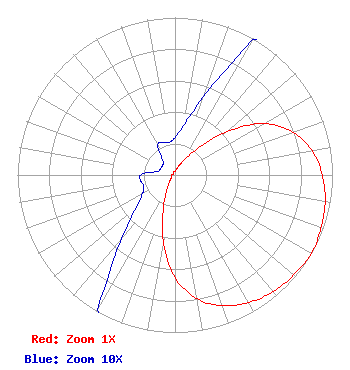
| Antenna Data for Antenna Id: 1005567 KYMU-LD LD File: -0000081648 Scala - 2x2CA2 Service: LD Standard Pattern: N Pattern and Field Values Include a 120° Clockwise Rotation |  | ||||||||||||||||||
| Azimuth | Ratio | Azimuth | Ratio | Azimuth | Ratio | Azimuth | Ratio | ||||||||||||
| 0 | 0.024 | 10 | 0.032 | 20 | 0.053 | 30 | 0.099 | ||||||||||||
| 40 | 0.211 | 50 | 0.426 | 60 | 0.651 | 70 | 0.797 | ||||||||||||
| 80 | 0.884 | 90 | 0.935 | 100 | 0.968 | 110 | 0.986 | ||||||||||||
| 120 | 1.000 | 130 | 0.986 | 140 | 0.968 | 150 | 0.935 | ||||||||||||
| 160 | 0.884 | 170 | 0.797 | 180 | 0.651 | 190 | 0.426 | ||||||||||||
| 200 | 0.211 | 210 | 0.099 | 220 | 0.053 | 230 | 0.032 | ||||||||||||
| 240 | 0.024 | 250 | 0.021 | 260 | 0.022 | 270 | 0.022 | ||||||||||||
| 280 | 0.012 | 290 | 0.010 | 300 | 0.010 | 310 | 0.010 | ||||||||||||
| 320 | 0.012 | 330 | 0.022 | 340 | 0.022 | 350 | 0.021 | ||||||||||||
Structure Registration Number 1011408 [ASR Heights Differ from KYMU-LD Application] Structure Type: GTOWER Registered To: American Towers LLC Structure Address: 1518 Queen Anne Ave N (207106) Seattle, WA County Name: King County ASR Issued: 09/28/2022 Date Built: 07/22/1957 Site Elevation: 125.3 m (411 ft.) Structure Height: 161.5 m (530 ft.) Height Overall: 185.3 m (608 ft.) Overall Height AMSL: 310.6 m (1019 ft.) FAA Determination: 09/17/2022 FAA Study #: 2022-ANM-4725-OE FAA Circular #: 70/7460-1M Paint & Light FAA Chapters: 4, 8, 15 PRIOR STUDY 2017-ANM-895-OE 47-37-58.9 N 122-21-23.9 W (NAD 83) 47-37-59.5 N 122-21-19.4 W (Converted to NAD 27) |
3901 Highway 121 Bedford, TX 76021 Phone: 817-571-1229 Not-for-Profit | Title: Manager Date: 09/18/2019 Application Certifier Denver Digital Television, LLC Denver Digital Television, LLC 3111 Bel Air Drive Unit 25D Las Vegas, NV 89109 Applicant Penny Drucker DDTV, LLC PO Box 255 795 Cielo Lane Evergreen, CO 80437 Susan Hansen Engineering Consultant 2355 Ranch Drive Westminster, CO 80234 Engineering Consultant James Talens Counsel 6017 Woodley Road McLean, VA 22101 | |||||||||||||||||