|
WUVG-DT
Call Sign History
WUVG-DT from 06/23/2009
WUVG-TV from 01/01/2004
WUVG from 11/01/2001
WHOT-TV from 10/15/1999
WNGM-TV from 02/17/1987
811124KF from ???
|
Channel 35DT
Virtual Channel 34
|
Athens, GA
|
|
| WUVG-DT Service: LD - Digital TV Translator or LPTV Station | | Channel: 35 Zone: |
| Athens, Georgia |
| Nielsen DMA™: Atlanta |
| Network: UNIVISION |
| Virtual Channel: 34 |
| DTV TSID: 737 |
| Facility ID: 48813 | | FRN: 0005414891 |
Status: LIC
Application Accepted: 09/20/2019
License Expires: 04/01/2021
File Number: 0000081844
FCC Website Links:
LMS Facility Details
This Application
Other WUVG-DT Applications
Including Superseded Applications
Service Contour - Open Street Map or USGS Map (51 dBu)
Service Contour - KML / Google Earth (51 dBu)
Rabbit Ears Info Search for WUVG-DT
Site Location: 33-59-35.9 N 83-24-55.9 W (NAD 83)
Site Location: 33-59-35.5 N 83-24-56.3 W (Converted to NAD 27)
ERP: 13.5 kW
Polarization: Elliptically polarized
Electrical Beam Tilt: 1.25 degrees
R/C AGL: 103.6 m (340 ft.)
R/C AMSL: 334.9 m (1099 ft.)
Emission Mask: Full Service
Site Elevation: 231.3 m. (759 ft.)
Height Overall*: 120.4 m (395 ft.)
(* As Filed In This Application, may differ from ASR Data, Below.)
Directional Antenna - Antenna Make/Model: Electronics Research Inc. AL12-35-PL
Antenna ID:
Polarization: Elliptically polarized
|
Antenna Data for Antenna Id:
WUVG-DT LD File: -0000081844
Electronics Research Inc. - AL12-35-PL
Service: LD
Standard Pattern: N
Pattern and Field Values Include a 190° Clockwise Rotation
|
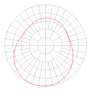 |
| Azimuth | Ratio | Azimuth | Ratio | Azimuth | Ratio | Azimuth | Ratio |
| 0 | 0.672 | 10 | 0.676 | 20 | 0.672 | 30 | 0.659 |
| 40 | 0.642 | 50 | 0.623 | 60 | 0.608 | 70 | 0.602 |
| 80 | 0.609 | 90 | 0.631 | 100 | 0.668 | 110 | 0.715 |
| 120 | 0.767 | 130 | 0.820 | 140 | 0.871 | 150 | 0.915 |
| 160 | 0.951 | 170 | 0.978 | 180 | 0.994 | 190 | 1.000 |
| 200 | 0.994 | 210 | 0.978 | 220 | 0.951 | 230 | 0.915 |
| 240 | 0.871 | 250 | 0.820 | 260 | 0.767 | 270 | 0.715 |
| 280 | 0.668 | 290 | 0.631 | 300 | 0.609 | 310 | 0.602 |
| 320 | 0.608 | 330 | 0.623 | 340 | 0.642 | 350 | 0.659 |
|
Structure Information
Structure Registration Number 1022700
Structure Type: Registered To:
American Towers LLC
Structure Address:
178 Pepperidge Lane (026166)
Athens, GA
County Name: Clarke County
ASR Issued: 06/15/2016
Date Built: 08/18/2003
Site Elevation: 231.3 m (759 ft.)
Structure Height: 116.7 m (383 ft.)
Height Overall: 120.4 m (395 ft.)
Overall Height AMSL: 351.7 m (1154 ft.)
FAA Determination: 04/24/2012
FAA Study #: 2012-ASO-3342-OE
FAA Circular #: 70/7460-1K
Paint & Light FAA Chapters: 4, 8, 12
PRIOR STUDY 2007-ASO-532-OE
33-59-35.9 N 83-24-55.9 W (NAD 83)
33-59-35.5 N 83-24-56.3 W
(Converted to NAD 27)
|
WUVG-DT Licensee Information
Univision Atlanta LLC
8551 NW 30th Terrace
Miami, FL 33122
Phone: 310-348-3600
Limited Liability Company | 0000081844 Applicant Information
Christopher G. Wood
Title: SVP Assoc Gen Coun Gov and Reg Aff
Date: 09/20/2019
Application Certifier
Univision Atlanta LLC
Univision Atlanta LLC
5999 Center Drive
Los Angeles, CA 90045
Applicant
Matthew S. Delnero
Covington & Burling LLP
One Citycenter
850 Tenth Street, NW
Washington, DC 20001
|
Associated Land Mobile Licenses
|
| | WQOD296 |
Broadcast Auxiliary Low Power |
| Associated Microwave Licenses
|
| | WPJF323 |
7 GHz TV Intercity Relay |
| | WPJF322 |
7 GHz TV Studio Transmitter Link |
| | WQGY969 |
13 GHz TV Intercity Relay |
| | WPXR620 |
13 GHz TV Studio Transmitter Link |
|
