FCCInfo.com
A Service of Cavell, Mertz & Associates, Inc.
(855) FCC-INFO
|
|
WWKI-TV from 02/13/1985 830506KI from 05/06/1983 |
Virtual Channel 29 |  |
|
||||||||||||||||||
|
|
Status: LIC Application Accepted: 10/22/2019 License Expires: 08/01/2029 File Number: 0000087064 FCC Website Links: LMS Facility Details This Application Other WTTK Applications Including Superseded Applications Service Contour - Open Street Map or USGS Map (41 dBu) Service Contour - KML / Google Earth (41 dBu) Public Inspection Files Rabbit Ears Info Search for WTTK Site Location: 39-53-20.0 N 86-12-07.0 W (NAD 83) Site Location: 39-53-19.9 N 86-12-07.0 W (Converted to NAD 27) ERP: 400 kW Polarization: Horizontally polarized HAAT: 263 m (863 ft.) Electrical Beam Tilt: 0.55 degrees R/C AGL: 265.2 m (870 ft.) R/C AMSL: 512.1 m (1680 ft.) Site Elevation: 246.9 m. (810 ft.) Height Overall*: 317 m (1040 ft.) (* As Filed In This Application, may differ from ASR Data, Below.) Directional Antenna - Antenna Make/Model: DIELECTRIC TFU-16WB-1-R Antenna ID: 1005689 Polarization: Horizontally polarized | |||||||||||||||||||||
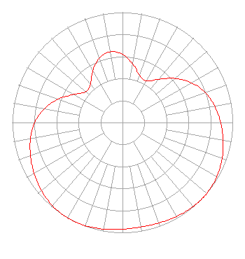
| Antenna Data for Antenna Id: 1005689 WTTK DX File: -0000087064 DIELECTRIC - TFU-16WB-1-R Service: DX Standard Pattern: N |  | |||||||||||||||||||||
| Azimuth | Ratio | Azimuth | Ratio | Azimuth | Ratio | Azimuth | Ratio | |||||||||||||||
| 0 | 0.619 | 10 | 0.537 | 20 | 0.453 | 30 | 0.436 | |||||||||||||||
| 40 | 0.510 | 50 | 0.622 | 60 | 0.723 | 70 | 0.798 | |||||||||||||||
| 80 | 0.849 | 90 | 0.889 | 100 | 0.926 | 110 | 0.961 | |||||||||||||||
| 120 | 0.987 | 130 | 0.999 | 133 | 1.000 | 140 | 0.996 | |||||||||||||||
| 150 | 0.983 | 160 | 0.969 | 170 | 0.963 | 180 | 0.968 | |||||||||||||||
| 190 | 0.982 | 200 | 0.995 | 210 | 0.999 | 220 | 0.987 | |||||||||||||||
| 230 | 0.960 | 240 | 0.926 | 250 | 0.888 | 260 | 0.847 | |||||||||||||||
| 270 | 0.795 | 280 | 0.720 | 290 | 0.619 | 300 | 0.508 | |||||||||||||||
| 310 | 0.435 | 320 | 0.453 | 330 | 0.538 | 340 | 0.619 | |||||||||||||||
| 350 | 0.651 | |||||||||||||||||||||
Structure Registration Number 1030684 Structure Type: TOWER Registered To: Tribune Media Company Structure Address: 2350 Westlane Rd Indianapolis, IN County Name: Marion County ASR Issued: 01/16/2020 Date Built: 01/01/1984 Site Elevation: 246.9 m (810 ft.) Structure Height: 298.7 m (980 ft.) Height Overall: 317 m (1040 ft.) Overall Height AMSL: 563.9 m (1850 ft.) FAA Determination: 11/04/1983 FAA Study #: 83-AGL-1413-OE FAA Circular #: 70/7460-1F Paint & Light FAA Chapters: 3, 4, 5, 9 RED LIGHTS/PAINT 39-53-20.0 N 86-12-07.0 W (NAD 83) 39-53-19.9 N 86-12-07.0 W (Converted to NAD 27) |
545 E. John Carpenter Freeway, Suite 700 Irving, TX 75062 Phone: 214-765-4229 Limited Liability Company | Title: Vice President/General Manager Date: 10/22/2019 Application Certifier Tribune Broadcasting Indianapolis, LLC Tribune Broadcasting Indianapolis, LLC 6910 Network Place Indianapolis, IN 46221 Applicant Louis R Dutreil, Jr Dutreil Lundin & Rackley Inc 3135 Southgate Circle Sarasota, FL 34239 Technical Consultant Jason Roberts Nexstar Broadcasting, Inc. 303 E. Wacker Drive Chicago, IL 60601 Assistant General Counsel Steve Zanolini Tribune Broadcasting Indianapolis, LLC 6910 Network Place Indianapolis, IN 46278 Chief Engineer | ||||||||||||||||||||
| ||||||||||||||||||||||