FCCInfo.com
A Service of Cavell, Mertz & Associates, Inc.
(855) FCC-INFO
|
|
WMYO from ??? WBKI-TV from 02/12/2018 WMYO from 07/07/2006 WFTE from 12/12/1990 WXZA from 11/01/1990 870827KE from ??? |
Virtual Channel 58 |  |
|
||||||||||||||||||
|
|
Status: LIC Application Accepted: 11/12/2019 License Expires: 08/01/2029 File Number: 0000088752 FCC Website Links: LMS Facility Details This Application Other WBKI Applications Including Superseded Applications Service Contour - Open Street Map or USGS Map (41 dBu) Service Contour - KML / Google Earth (41 dBu) Public Inspection Files Rabbit Ears Info Search for WBKI Site Location: 38-21-01.0 N 85-50-57.0 W (NAD 83) Site Location: 38-21-00.8 N 85-50-57.1 W (Converted to NAD 27) ERP: 725 kW Polarization: Horizontally polarized HAAT: 340.0 m (1115 ft.) Electrical Beam Tilt: 0.75 degrees R/C AGL: 242.9 m (797 ft.) R/C AMSL: 537 m (1762 ft.) Site Elevation: 294.1 m. (965 ft.) Height Overall*: 304.8 m (1000 ft.) (* As Filed In This Application, may differ from ASR Data, Below.) Directional Antenna - Antenna Make/Model: Electronics Research Inc. ATW19H3-HSCX-16H Antenna ID: 1005932 Polarization: Horizontally polarized | |||||||||||||||||||||
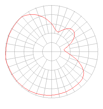
| Antenna Data for Antenna Id: 1005932 WBKI DX File: -0000088752 Electronics Research Inc. - ATW19H3-HSCX-16H Service: DX Standard Pattern: N |  | |||||||||||||||||||||
| Azimuth | Ratio | Azimuth | Ratio | Azimuth | Ratio | Azimuth | Ratio | |||||||||||||||
| 0 | 0.600 | 10 | 0.480 | 20 | 0.450 | 30 | 0.550 | |||||||||||||||
| 40 | 0.640 | 50 | 0.640 | 60 | 0.550 | 70 | 0.400 | |||||||||||||||
| 80 | 0.280 | 90 | 0.305 | 100 | 0.420 | 110 | 0.610 | |||||||||||||||
| 120 | 0.790 | 130 | 0.880 | 140 | 0.900 | 150 | 0.910 | |||||||||||||||
| 160 | 0.920 | 170 | 0.930 | 180 | 0.940 | 190 | 0.950 | |||||||||||||||
| 200 | 0.960 | 210 | 0.970 | 220 | 0.975 | 230 | 0.980 | |||||||||||||||
| 240 | 0.980 | 250 | 0.985 | 260 | 1.000 | 270 | 0.985 | |||||||||||||||
| 280 | 0.980 | 290 | 0.980 | 300 | 0.980 | 310 | 0.980 | |||||||||||||||
| 320 | 0.980 | 330 | 0.920 | 340 | 0.830 | 350 | 0.720 | |||||||||||||||
Structure Registration Number 1307446 Structure Type: GTOWER Registered To: Independence Television Company Structure Address: 5257 South Skyline Drive Floyds Knobs, IN County Name: Floyd County ASR Issued: 09/17/2018 Date Built: 11/15/2019 Site Elevation: 294.1 m (965 ft.) Structure Height: 288 m (945 ft.) Height Overall: 304.8 m (1000 ft.) Overall Height AMSL: 598.9 m (1965 ft.) FAA Determination: 08/08/2018 FAA Study #: 2018-AGL-12014-OE FAA Circular #: 70/7460-1L Paint & Light FAA Chapters: 3, 4, 5, 12 Removed expiration date from determination. Scenario 1./jjs/case#635066 38-21-01.0 N 85-50-57.0 W (NAD 83) 38-21-00.8 N 85-50-57.1 W (Converted to NAD 27) |
624 W. Muhammad Ali Boulevard Louisville, KY 40203 Phone: 502-584-6441 Corporation | Title: Assisstant Secretary Date: 11/12/2019 Application Certifier Independence Television Company Independence Television Company 624 Muhammad Ali Boulevard Louisville, KY 40203 Applicant Christina H. Burrow Cooley LLP 1299 Pennsylvania Avenue, NW Suite 700 Washington, DC 20004 Legal Representative Donald G Everist Cohen, Dippell and Everist, P.C. Cohen, Dippell and Everist, P.C. 1420 N Street NW, Suite One Washington, DC 20005 Technical Consultant Gary Schroder Independence Television Company 624 Muhammad Ali Boulevard Louisville, KY 40203 Chief Engineer | ||||||||||||||||||||