FCCInfo.com
A Service of Cavell, Mertz & Associates, Inc.
(855) FCC-INFO
|
|
K46II-D from 04/19/2010 K46II from 07/25/2005 K67FS from 11/25/1992 910503AY from ??? |
|
|
||||||||||||||||
|
|
Status: LIC Application Accepted: 03/02/2020 License Expires: 12/01/2030 File Number: 0000106976 FCC Website Links: LMS Facility Details This Application Other K04SB-D Applications Including Superseded Applications Service Contour - Open Street Map or USGS Map (43 dBu) Service Contour - KML / Google Earth (43 dBu) Rabbit Ears Info Search for K04SB-D Site Location: 35-26-17.1 N 118-44-26.3 W (NAD 83) Site Location: 35-26-17.3 N 118-44-23.0 W (Converted to NAD 27) ERP: 0.7 kW Polarization: Horizontally polarized R/C AGL: 17.4 m (57 ft.) R/C AMSL: 1091.8 m (3582 ft.) Emission Mask: Full Service Site Elevation: 1074.4 m. (3525 ft.) Height Overall*: 87.7 m (288 ft.) (* As Filed In This Application, may differ from ASR Data, Below.) Directional Antenna - Antenna Make/Model: KATHREIN CL26_2_STACKED Antenna ID: 1004576 Polarization: Horizontally polarized | ||||||||||||||||||
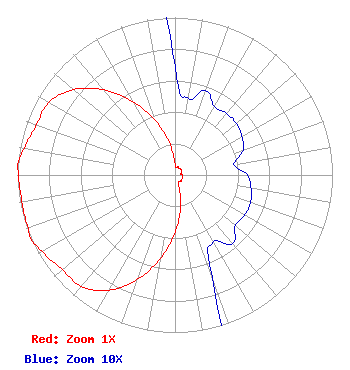
| Antenna Data for Antenna Id: 1004576 K04SB-D LD File: -0000106976 KATHREIN - CL26_2_STACKED Service: LD Standard Pattern: Y Pattern and Field Values Include a 260° Clockwise Rotation |  | ||||||||||||||||||
| Azimuth | Ratio | Azimuth | Ratio | Azimuth | Ratio | Azimuth | Ratio | ||||||||||||
| 0 | 0.069 | 10 | 0.049 | 20 | 0.057 | 30 | 0.050 | ||||||||||||
| 40 | 0.051 | 50 | 0.051 | 60 | 0.049 | 70 | 0.046 | ||||||||||||
| 80 | 0.038 | 90 | 0.046 | 100 | 0.049 | 110 | 0.051 | ||||||||||||
| 120 | 0.051 | 130 | 0.050 | 140 | 0.057 | 150 | 0.049 | ||||||||||||
| 160 | 0.069 | 170 | 0.209 | 180 | 0.367 | 190 | 0.538 | ||||||||||||
| 200 | 0.707 | 210 | 0.844 | 220 | 0.924 | 230 | 0.935 | ||||||||||||
| 240 | 0.973 | 246 | 1.000 | 250 | 0.993 | 260 | 0.987 | ||||||||||||
| 270 | 0.993 | 274 | 1.000 | 280 | 0.973 | 290 | 0.935 | ||||||||||||
| 300 | 0.924 | 310 | 0.844 | 320 | 0.707 | 330 | 0.538 | ||||||||||||
| 340 | 0.367 | 350 | 0.209 | ||||||||||||||||
Structure Registration Number 1015947 Structure Type: LTOWER Registered To: Nexstar Media Inc. Structure Address: Nr Breckenridge Rd 25.7 Km Ene Bakersfield, CA County Name: Kern County ASR Issued: 05/28/2021 Date Built: 08/01/1967 Site Elevation: 1074.4 m (3525 ft.) Structure Height: 60.9 m (200 ft.) Height Overall: 87.7 m (288 ft.) Overall Height AMSL: 1162.1 m (3813 ft.) FAA Determination: 11/04/2014 FAA Study #: 2014-AWP-6884-OE FAA Circular #: 70/7460-1J Paint & Light FAA Chapters: 3, 4, 5, 13 PRIOR STUDY 1997-AWP-473-OE. OM&L to remain the same as prior study = PAINT/RED LIGHTS 35-26-17.1 N 118-44-26.3 W (NAD 83) 35-26-17.3 N 118-44-23.0 W (Converted to NAD 27) |
2900 West Alameda Avenue 5th Floor Burbank, CA 91505 Phone: 747-201-5295 Not-for-Profit | Title: Senior Vice President and General Counsel Date: 03/02/2020 Application Certifier Public Media Group of Southern California 2900 West Alameda Avenue 6th Floor Burbank, CA 91505 Applicant June M. Baldwin Public Media Group of Southern California 2900 West Alameda Avenue 6th Floor Burbank, CA 91505 Sr. VP, General Counsel Jeremy Howard Public Media Group of Southern California 2900 West Alameda Avenue 6th Floor Burbank, CA 91505 Chief Engineer William Meintel Meintel, Sgrignoli & Wallace P.O. Box 907 Warrenton, VA 20188 Technical Representative Melodie A. Virtue Foster Garvey PC 1000 Potomac Street, NW Suite 200 Washington, DC 20007 FCC Counsel | |||||||||||||||||