FCCInfo.com
A Service of Cavell, Mertz & Associates, Inc.
(855) FCC-INFO
|
|
WUWT-CD from 07/18/2012 WUWT-CA from 11/01/2001 W09BM from 10/05/1998 W26BU from 10/05/1998 W41CD from 10/05/1998 W09BM from 06/03/1997 W41CD from 01/28/1997 W09BM from 01/28/1997 820412SR from ??? |
|
|
||||||||||||||||
|
|
Status: LIC Application Accepted: 05/14/2020 License Expires: 08/01/2029 File Number: 0000113689 FCC Website Links: LMS Facility Details This Application Other WUWT-LD Applications Including Superseded Applications Service Contour - Open Street Map or USGS Map (51 dBu) Service Contour - KML / Google Earth (51 dBu) Rabbit Ears Info Search for WUWT-LD Site Location: 36-26-46.2 N 89-02-12.2 W (NAD 83) Site Location: 36-26-46.0 N 89-02-12.0 W (Converted to NAD 27) ERP: 14.3 kW Polarization: Horizontally polarized Electrical Beam Tilt: 1.75 degrees R/C AGL: 101 m (331 ft.) R/C AMSL: 203.1 m (666 ft.) Emission Mask: Stringent Site Elevation: 102.1 m. (335 ft.) Height Overall*: 106.4 m (349 ft.) (* As Filed In This Application, may differ from ASR Data, Below.) Directional Antenna - Antenna Make/Model: Propagation System Inc PSILP24OI Antenna ID: 20433 Polarization: Horizontally polarized | ||||||||||||||||||
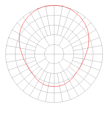
| Antenna Data for Antenna Id: 20433 WUWT-LD LD File: -0000113689 Propagation System Inc - PSILP24OI Service: LD Standard Pattern: Y |  | ||||||||||||||||||
| Azimuth | Ratio | Azimuth | Ratio | Azimuth | Ratio | Azimuth | Ratio | ||||||||||||
| 0 | 1.000 | 10 | 1.000 | 20 | 0.980 | 30 | 0.950 | ||||||||||||
| 40 | 0.910 | 50 | 0.870 | 60 | 0.820 | 70 | 0.760 | ||||||||||||
| 80 | 0.710 | 90 | 0.660 | 100 | 0.630 | 110 | 0.610 | ||||||||||||
| 120 | 0.600 | 130 | 0.600 | 140 | 0.620 | 150 | 0.640 | ||||||||||||
| 160 | 0.660 | 170 | 0.670 | 180 | 0.670 | 190 | 0.670 | ||||||||||||
| 200 | 0.660 | 210 | 0.640 | 220 | 0.620 | 230 | 0.600 | ||||||||||||
| 240 | 0.600 | 250 | 0.610 | 260 | 0.630 | 270 | 0.660 | ||||||||||||
| 280 | 0.710 | 290 | 0.760 | 300 | 0.820 | 310 | 0.870 | ||||||||||||
| 320 | 0.910 | 330 | 0.950 | 340 | 0.980 | 350 | 1.000 | ||||||||||||
Structure Registration Number 1225622 Structure Type: TOWER Structure Address: 3862 Barham Road Union City, TN County Name: Obion County ASR Issued: 05/15/2001 Site Elevation: 102.1 m (335 ft.) Structure Height: 106.4 m (349 ft.) Height Overall: 106.4 m (349 ft.) Overall Height AMSL: 208.5 m (684 ft.) FAA Determination: 10/14/1993 FAA Study #: 93-ASO-1373-OE FAA Circular #: Paint & Light FAA Chapters: A1, H MEDIUM INTENSITY WHITE LIGHTS. 36-26-46.2 N 89-02-12.2 W (NAD 83) 36-26-46.0 N 89-02-12.0 W (Converted to NAD 27) |
Union City, TN 38261 Phone: 434-770-7813 Corporation | Title: President Date: 05/14/2020 Application Certifier Harpole Telecom, Inc. Harpole Telecom, Inc. Union City, TN 38261 Applicant Bryan H Baker Southern Broadcast Solutions 403 North Elm Avenue Sylacauga, AL 35150 Consulting Engineer Kathleen Victory Fletcher, Heald & Hildreth, P.L.C. 1300 N. 17th St. 11th Floor Arlington, VA 22209 FCC Counsel | |||||||||||||||||
| |||||||||||||||||||