|
KTLN-TV
Call Sign History
KTLN-TV from 06/04/1999
KWOK from 06/16/1993
DKWOK from 02/02/1993
KWOK from 11/30/1990
|
Channel 22DT
Virtual Channel 68
|
Palo Alto, CA
|
|
| KTLN-TV Service: DT - Digital TV | | Channel: 22 Zone: 2 |
| Palo Alto, California |
| Nielsen DMA™: San Francisco - Oak - San Jose |
| Network: Heroes & Icons |
| Virtual Channel: 68 |
| DTV TSID: 319 |
| Facility ID: 49153 | | FRN: 0028887529 |
KTLN-TV is a channel sharing guest of KAXT-CD, San Franciso, San Jo, California
Status: LIC
Application Accepted: 07/29/2020
License Expires: 12/01/2030
File Number: 0000118933
FCC Website Links:
LMS Facility Details
This Application
Other KTLN-TV Applications
Including Superseded Applications
Service Contour - Open Street Map or USGS Map (41 dBu)
Service Contour - KML / Google Earth (41 dBu)
Public Inspection Files
Rabbit Ears Info Search for KTLN-TV
Site Location: 37-29-57.0 N 121-52-20.0 W (NAD 83)
Site Location: 37-29-57.2 N 121-52-16.2 W (Converted to NAD 27)
ERP: 15 kW
Polarization: Elliptically polarized
Electrical Beam Tilt: 4 degrees
R/C AGL: 115.2 m (378 ft.)
R/C AMSL: 909.5 m (2984 ft.)
Emission Mask: Full Service
Site Elevation: 794.3 m. (2606 ft.)
Height Overall*: 135 m (443 ft.)
(* As Filed In This Application, may differ from ASR Data, Below.)
Directional Antenna - Antenna Make/Model: DIELECTRIC TUM-C2-2/4M-1 SM
Antenna ID: 1007035
Polarization: Elliptically polarized
|
Antenna Data for Antenna Id: 1007035
KTLN-TV DT File: -0000118933
DIELECTRIC - TUM-C2-2/4M-1 SM
Service: DT
Standard Pattern: N
Pattern and Field Values Include a 359° Clockwise Rotation
|
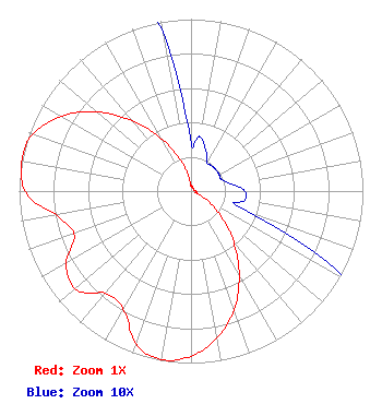 |
| Azimuth | Ratio | Azimuth | Ratio | Azimuth | Ratio | Azimuth | Ratio |
| 9 | 0.032 | 19 | 0.026 | 29 | 0.019 | 39 | 0.019 |
| 49 | 0.019 | 59 | 0.019 | 69 | 0.019 | 79 | 0.023 |
| 89 | 0.031 | 99 | 0.032 | 109 | 0.031 | 119 | 0.104 |
| 129 | 0.216 | 139 | 0.370 | 149 | 0.544 | 159 | 0.716 |
| 169 | 0.857 | 179 | 0.953 | 189 | 0.995 | 199 | 0.954 |
| 209 | 0.799 | 219 | 0.769 | 229 | 0.878 | 239 | 0.849 |
| 249 | 0.727 | 259 | 0.784 | 269 | 0.955 | 279 | 0.999 |
| 283 | 1.000 | 289 | 0.982 | 299 | 0.884 | 309 | 0.732 |
| 319 | 0.551 | 329 | 0.373 | 339 | 0.218 | 349 | 0.105 |
| 359 | 0.031 |
Structure Information
Structure Registration Number 1044718
[ASR Heights Differ from KTLN-TV Application]
Structure Type: GTOWER
Registered To:
SBA Towers XI, LLC
Structure Address:
Mount Allison 3 Mi E 9526 Weller Road (ca1899d-a)
Fremont, CA
County Name: Alameda County
ASR Issued: 01/03/2025
Date Built: 02/25/1998
Site Elevation: 794.3 m (2606 ft.)
Structure Height: 115.8 m (380 ft.)
Height Overall: 122.8 m (403 ft.)
Overall Height AMSL: 917.1 m (3009 ft.)
FAA Determination: 12/18/2024
FAA Study #: 2024-AWP-13707-OE
FAA Circular #: 70/7460-1J
Paint & Light FAA Chapters: 8, 13
OM&L to remain the same as prior study = A MED-DUAL SYSTEM
37-29-57.7 N 121-52-20.7 W (NAD 83)
37-29-57.9 N 121-52-16.9 W
(Converted to NAD 27)
|
KTLN-TV Licensee Information
KTLN-TV LLC
26 North Halsted Street
Chicago, IL 60661
Phone: 312-705-2600
Limited Liability Company | 0000118933 Applicant Information
Application Certifier
OTA Broadcasting (SFO), LLC
OTA Broadcasting (SFO), LLC
11710 Plaza America Drive
Suite 2000
Reston, VA 20190
Applicant
ARI Meltzer
Wiley Rein LLP
1776 K Street NW
Washington, DC 20006
|
Associated Land Mobile Licenses
|
| (No Records Found) |
| Associated Microwave Licenses
|
| (No Records Found) |
|
