|
| WXOW Service: DX - Digital TV Auxiliary Transmitting Antenna | | Channel: 28 Zone: 2 |
| La Crosse, Wisconsin |
| Nielsen DMA™: La Crosse - Eau Claire |
| Network: ABC, Catchy TV, This TV thru 5/24/24, then MeTV Toons Eff 5/29/24, Court TV, Justice Networks, The Grio |
| Virtual Channel: 19 |
| DTV TSID: 3197 |
| Facility ID: 64549 | | FRN: 0030885057 |
Status: LIC
Application Accepted: 02/16/2021
License Expires: 12/01/2029
File Number: 0000136324
FCC Website Links:
LMS Facility Details
This Application
Other WXOW Applications
Including Superseded Applications
Service Contour - Open Street Map or USGS Map (41 dBu)
Service Contour - KML / Google Earth (41 dBu)
Public Inspection Files
Rabbit Ears Info Search for WXOW
Site Location: 43-48-23.0 N 91-22-03.0 W (NAD 83)
Site Location: 43-48-23.1 N 91-22-02.5 W (Converted to NAD 27)
ERP: 99 kW
Polarization: Horizontally polarized
HAAT: 334.5 m (1097 ft.)
Electrical Beam Tilt: 1.05 degrees
R/C AGL: 229.4 m (753 ft.)
R/C AMSL: 603 m (1978 ft.)
Site Elevation: 373.6 m. (1226 ft.)
Height Overall*: 249.7 m (819 ft.)
(* As Filed In This Application, may differ from ASR Data, Below.)
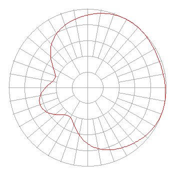
Directional Antenna - Antenna Make/Model: DIELECTRIC TFU-8WB-C160
Antenna ID: 1004018
Polarization: Horizontally polarized
|
Structure Information
Structure Registration Number 1035149
Structure Type: TOWER
Registered To:
La Crosse TV License Company, LLC
Structure Address:
3705 Cth 25
La Crescent, MN
County Name: Houston County
ASR Issued: 08/19/2021
Date Built: 10/23/1982
Site Elevation: 373.6 m (1226 ft.)
Structure Height: 232.7 m (763 ft.)
Height Overall: 249.7 m (819 ft.)
Overall Height AMSL: 623.3 m (2045 ft.)
FAA Determination: 04/14/1983
FAA Study #: 82-AGL-53-OE
FAA Circular #: 70/7460-1F
Paint & Light FAA Chapters: 4, 6, 9
43-48-23.0 N 91-22-03.0 W (NAD 83)
43-48-23.1 N 91-22-02.5 W
(Converted to NAD 27)
|
WXOW(DT) Licensee Information
La Crosse TV License Company, LLC
1925 Century Park East, 10th Floor
Los Angeles, CA 90067
Phone: 310-277-3500
Limited Liability Company | 0000136324 Applicant Information
Ralph M. Oakley
Title: President
Date: 02/16/2021
Application Certifier
WXOW-WQOW License, LLC
WXOW-WQOW License, LLC
P.O. Box 909
Quincy, IL 62306
Applicant
Stephen Hartzell
Brooks, Pierce Et Al.
150 Fayetteville Street
Suite 1700
Raleigh, NC 27601
Scott Turpie
Lohnes & Culver, LLC
Alexandria, VA 22302
Sr. Technical Consultant
|