
FCCInfo.com
A Service of Cavell, Mertz & Associates, Inc.
(855) FCC-INFO
|
|
|
|
|
||||||||||||||||
|
|
Channel: 206C3 89.1 MHz Packwood, Washington Service: FM - A full-service FM station or application. Facility ID: 766725 Fac. Service: FM Status: Construction Permit Application Accepted: 11/09/2021 Application Granted: 02/18/2022 File Number: 0000167224 CP Expires: 02/18/2025 Application Type: Non-Commercial Educational New NCE FM CP FCC Website Links: LMS Facility Details This Application Other Applications Other Applications in CDBS Including Superseded Applications Mailing Address Correspondence for Correspondence related to application 0000167224 Service Contour - Open Street Map or USGS Map (60 dBu) Service Contour - KML / Google Earth (60 dBu) Facility Type: NON-COMMERCIAL EDUC. FM Class: C3, A Zone II station; with 6kW-25kW ERP and a class contour distance 28km-39km Site Location: 46-37-27.0 N 121-23-16.7 W (NAD 83) Site Location: 46-37-27.6 N 121-23-12.4 W (Converted to NAD 27) Effective Radiated Power: 0.5 kW Horiz. ; 0 kW Vert. Antenna Center HAAT: 446.1 m Horiz.; 0 m Vert. Antenna Center AMSL: 1826.7 m Horiz.; 0 m Vert. Antenna Center HAG: 3.1 m Horiz.; 0 m Vert. Site Elevation: 1823.6 m. (5983 ft.) Height Overall*: 19.8 m (65 ft.) (* As Filed In This Application, may differ from ASR Data, Below.) Directional Antenna Antenna Make/Model: None Antenna ID: 69-2019-08-06 Polarization: | ||||||||||||||||||
| Antenna Data for Antenna Id: 69-2019-08-06 FM File: -0000167224 None - Service: FM | 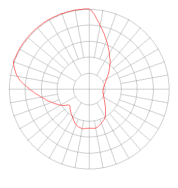 | ||||||||||||||||||
| Azimuth | Ratio | Azimuth | Ratio | Azimuth | Ratio | Azimuth | Ratio | ||||||||||||
| 0 | 1.000 | 10 | 0.802 | 20 | 0.640 | 30 | 0.509 | ||||||||||||
| 40 | 0.405 | 50 | 0.321 | 60 | 0.255 | 70 | 0.215 | ||||||||||||
| 80 | 0.190 | 90 | 0.178 | 100 | 0.178 | 110 | 0.190 | ||||||||||||
| 120 | 0.215 | 130 | 0.255 | 140 | 0.321 | 150 | 0.405 | ||||||||||||
| 160 | 0.453 | 170 | 0.496 | 180 | 0.489 | 190 | 0.502 | ||||||||||||
| 200 | 0.474 | 210 | 0.409 | 220 | 0.360 | 230 | 0.321 | ||||||||||||
| 240 | 0.405 | 250 | 0.493 | 260 | 0.598 | 270 | 0.745 | ||||||||||||
| 280 | 0.907 | 290 | 1.000 | 300 | 1.000 | 310 | 1.000 | ||||||||||||
| 320 | 1.000 | 330 | 1.000 | 340 | 1.000 | 350 | 1.000 | ||||||||||||
Structure Registration Number 1218537 Structure Type: MTOWER Registered To: UNITED STATES CELLULAR CORPORATION Structure Address: 18935 Us Hwy 12 White Pass, WA County Name: Lewis County ASR Issued: 12/30/2023 Date Built: 03/25/1994 Site Elevation: 1823.6 m (5983 ft.) Structure Height: 15.2 m (50 ft.) Height Overall: 19.8 m (65 ft.) Overall Height AMSL: 1843.4 m (6048 ft.) FAA Determination: 10/17/2022 FAA Study #: 2022-ANM-5537-OE Paint & Light FAA Chapters: NONE PRIOR STUDY 2012-ANM-1315-OE 46-37-27.0 N 121-23-16.7 W (NAD 83) 46-37-27.6 N 121-23-12.4 W (Converted to NAD 27) |
1914 Yakima Ave, Unit A Tacoma, WA 98405 Phone: 253-365-0001 Not-for-Profit | Title: Board Member Date: 11/09/2021 Application Certifier The Interest Compound 1914 Yakima Ave, Unit A Tacoma, WA 98405 Applicant Rebecca Friedman The Interest Compound 1914 Yakima Ave, Unit A Tacoma, WA 98405 Todd Urick Independent Consultant 28631 Sloan Canyon Rd Castaic, CA 91384 | |||||||||||||||||