FCCInfo.com
A Service of Cavell, Mertz & Associates, Inc.
(855) FCC-INFO
|
|
|
|
|
||||||||||||||||
|
|
W249EE Channel: 249D 97.7 MHz Warren, Ohio Service: FX - A translator or application for a translator. Facility ID: 201039 FRN: 0022455224 Fac. Service: FX Programming Delivery Method: Unspecified Status: LIC Application Accepted: 11/19/2021 Application Granted: 12/27/2021 File Number: 0000169836 License Expires: 10/01/2028 Application Type: License To Cover FCC Website Links: LMS Facility Details This Application Other W249EE Applications Other W249EE Applications in CDBS Including Superseded Applications Mailing Address Correspondence for W249EE Correspondence related to application 0000169836 Service Contour - Open Street Map or USGS Map (60 dBu) Service Contour - KML / Google Earth (60 dBu) Facility Type: FM STATION Class: D, A Noncommercial educational operating with no more than 10W Site Location: 41-03-23.6 N 80-38-43.3 W (NAD 83) Site Location: 41-03-23.4 N 80-38-44.0 W (Converted to NAD 27) Effective Radiated Power: 0.035 kW Transmitter Output Power: 0.067 kW Antenna Center HAAT: 0 m Antenna Center AMSL: 477 m (1565 ft.) Antenna Center HAG: 140 m (459 ft.) Site Elevation: 337 m. (1106 ft.) Height Overall*: 436 m (1430 ft.) (* As Filed In This Application, may differ from ASR Data, Below.) Directional Antenna Antenna Make/Model: Kathjrein/Scala CA2-FM/CP Antenna ID: 133243 Polarization: H
| ||||||||||||||||||
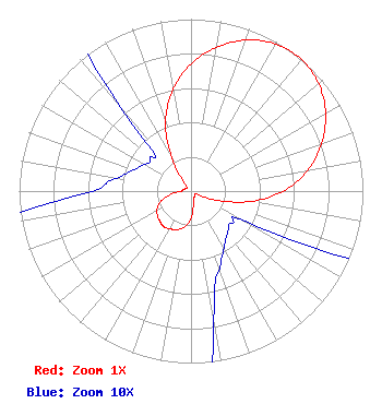
| Antenna Data for Antenna Id: 133243 W249EE FX File: -0000169836 Kathjrein/Scala - CA2-FM/CP Service: FX Pattern and Field Values Include a 38° Clockwise Rotation |  | ||||||||||||||||||
| Azimuth | Ratio | Azimuth | Ratio | Azimuth | Ratio | Azimuth | Ratio | ||||||||||||
| 8 | 0.829 | 18 | 0.920 | 28 | 0.979 | 38 | 1.000 | ||||||||||||
| 48 | 0.979 | 58 | 0.920 | 68 | 0.829 | 78 | 0.715 | ||||||||||||
| 88 | 0.570 | 98 | 0.388 | 108 | 0.187 | 118 | 0.045 | ||||||||||||
| 128 | 0.030 | 138 | 0.032 | 148 | 0.037 | 158 | 0.046 | ||||||||||||
| 168 | 0.065 | 178 | 0.142 | 188 | 0.202 | 198 | 0.234 | ||||||||||||
| 208 | 0.250 | 218 | 0.260 | 228 | 0.250 | 238 | 0.234 | ||||||||||||
| 248 | 0.202 | 258 | 0.142 | 268 | 0.065 | 278 | 0.046 | ||||||||||||
| 288 | 0.037 | 298 | 0.032 | 308 | 0.030 | 318 | 0.045 | ||||||||||||
| 328 | 0.187 | 338 | 0.399 | 348 | 0.570 | 358 | 0.715 | ||||||||||||
Structure Registration Number 1013678 Structure Type: GTOWER Registered To: American Towers, LLC Structure Address: 3930 Sunset Blvd (youngstown S. 1433 #307645) Youngstown, OH County Name: Mahoning County ASR Issued: 02/07/2020 Date Built: 11/15/1976 Site Elevation: 336.8 m (1105 ft.) Structure Height: 417.9 m (1371 ft.) Height Overall: 435.9 m (1430 ft.) Overall Height AMSL: 772.7 m (2535 ft.) FAA Determination: 01/24/2007 FAA Study #: 2006-AGL-10122-OE FAA Circular #: 70/7460-1J Paint & Light FAA Chapters: 4, 7, 13 OM&L to remain the same as prior study = 24-HR HI-STROBES 41-03-23.4 N 80-38-43.0 W (NAD 83) 41-03-23.2 N 80-38-43.7 W (Converted to NAD 27) |
3032 Vega Avenue Cleveland, OH 44113 Phone: 216-214-0176 Limited Liability Company | Title: Member-Manager Date: 11/19/2021 Application Certifier Sagittarius Commincations, LLC Sagittarius Commincations, LLC 3032 Vega Avenue Cleveland, OH 44113 Applicant John S Neely Miller and Neely, PC 3750 University Blvd.West Suite 203 Kensington, MD 20895 Attorney Edward A Schober, PE Radiotechniques Engineering, LLC Haddon Heights, NJ 08035 Consultingengineer | |||||||||||||||||