FCCInfo.com
A Service of Cavell, Mertz & Associates, Inc.
(855) FCC-INFO
|
|
KEGA from 10/02/1989 KBCB from 02/10/1989 821109KF from ??? |
Virtual Channel 24 |
|
||||||||||||||||||
|
|
Status: LIC Application Accepted: 04/13/2022 License Expires: 02/01/2031 File Number: 0000189329 FCC Website Links: LMS Facility Details This Application Other KBCB Applications Including Superseded Applications Service Contour - Open Street Map or USGS Map (41 dBu) Service Contour - KML / Google Earth (41 dBu) Public Inspection Files Rabbit Ears Info Search for KBCB Site Location: 48-40-45.0 N 122-50-36.0 W (NAD 83) Site Location: 48-40-45.6 N 122-50-31.3 W (Converted to NAD 27) ERP: 208 kW Polarization: Horizontally polarized HAAT: 757 m (2484 ft.) Electrical Beam Tilt: 0.75 degrees R/C AGL: 148.4 m (487 ft.) R/C AMSL: 792.6 m (2600 ft.) Site Elevation: 644.2 m. (2114 ft.) Height Overall*: 160 m (525 ft.) (* As Filed In This Application, may differ from ASR Data, Below.) Directional Antenna - Antenna Make/Model: R.F. Systems RD32UA16 Antenna ID: 43180 Polarization: Horizontally polarized | ||||||||||||||||||||
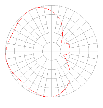
| Antenna Data for Antenna Id: 43180 KBCB DT File: -0000189329 R.F. Systems - RD32UA16 Service: DT Standard Pattern: Y |  | ||||||||||||||||||||
| Azimuth | Ratio | Azimuth | Ratio | Azimuth | Ratio | Azimuth | Ratio | ||||||||||||||
| 0 | 0.870 | 10 | 0.770 | 20 | 0.630 | 30 | 0.470 | ||||||||||||||
| 40 | 0.360 | 50 | 0.280 | 60 | 0.350 | 70 | 0.400 | ||||||||||||||
| 80 | 0.400 | 90 | 0.400 | 100 | 0.350 | 110 | 0.280 | ||||||||||||||
| 120 | 0.360 | 130 | 0.470 | 140 | 0.630 | 150 | 0.770 | ||||||||||||||
| 160 | 0.870 | 170 | 0.950 | 180 | 1.000 | 190 | 1.000 | ||||||||||||||
| 200 | 0.970 | 210 | 0.950 | 220 | 0.920 | 230 | 0.930 | ||||||||||||||
| 240 | 0.960 | 250 | 0.980 | 260 | 1.000 | 270 | 0.980 | ||||||||||||||
| 280 | 0.960 | 290 | 0.930 | 300 | 0.920 | 310 | 0.950 | ||||||||||||||
| 320 | 0.970 | 330 | 1.000 | 340 | 1.000 | 350 | 0.950 | ||||||||||||||
Structure Registration Number 1032381 Structure Type: Registered To: K2 Towers III, LLC Structure Address: Approx 1/2 Mile West Of Summit Of Mt Constitution, Orcas Is. Eastsound, WA County Name: San Juan County ASR Issued: 08/20/2025 Date Built: 05/17/1995 Site Elevation: 644.2 m (2114 ft.) Structure Height: 152.4 m (500 ft.) Height Overall: 160 m (525 ft.) Overall Height AMSL: 804.2 m (2638 ft.) FAA Determination: 07/19/2000 FAA Study #: 00-ANM-0172-OE FAA Circular #: 70/7460-1K Paint & Light FAA Chapters: 4, 8, 12 48-40-45.0 N 122-50-36.0 W (NAD 83) 48-40-45.6 N 122-50-31.3 W (Converted to NAD 27) |
Marion, IL 62959 Phone: 618-997-4700 Not-for-Profit | Title: President Date: 04/13/2022 Application Certifier Radiant Life Ministries, Inc. PO Box 1010 Marion, IL 62959 Applicant Kevin T Fisher Smith and Fisher, LLC 4791 Wintergreen Court Woodbridge, VA 22192 Engineering Consultant Joseph C Chautin Hardy, Carey, Chautin & Balkin, LLP 1080 West Causeway Approach Mandeville, LA 70471 Attorney-at-Law | |||||||||||||||||||