FCCInfo.com
A Service of Cavell, Mertz & Associates, Inc.
(855) FCC-INFO
|
|
KJEO from ??? |
Virtual Channel 47 |  |
|
||||||||||||||||||||||||||||||
|
|
Status: LIC Application Accepted: 05/19/2022 License Expires: 12/01/2022 File Number: 0000191060 FCC Website Links: LMS Facility Details This Application Other KGPE Applications Including Superseded Applications Service Contour - Open Street Map or USGS Map (41 dBu) Service Contour - KML / Google Earth (41 dBu) Public Inspection Files Rabbit Ears Info Search for KGPE Site Location: 37-04-14.0 N 119-25-34.0 W (NAD 83) Site Location: 37-04-14.2 N 119-25-30.5 W (Converted to NAD 27) ERP: 185 kW Polarization: Horizontally polarized HAAT: 577 m (1893 ft.) Electrical Beam Tilt: 1.5 degrees R/C AGL: 49 m (161 ft.) R/C AMSL: 1415 m (4642 ft.) Site Elevation: 1366 m. (4482 ft.) Height Overall*: 80 m (262 ft.) (* As Filed In This Application, may differ from ASR Data, Below.) Directional Antenna - Antenna Make/Model: Andrew ALP-24M6-HSP-34 Antenna ID: 44959 Polarization: Horizontally polarized | |||||||||||||||||||||||||||||||||
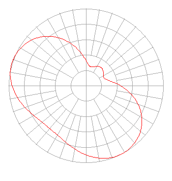
| Antenna Data for Antenna Id: 44959 KGPE DT File: -0000191060 Andrew - ALP-24M6-HSP-34 Service: DT Standard Pattern: Y Pattern and Field Values Include a 220° Clockwise Rotation |  | |||||||||||||||||||||||||||||||||
| Azimuth | Ratio | Azimuth | Ratio | Azimuth | Ratio | Azimuth | Ratio | |||||||||||||||||||||||||||
| 0 | 0.326 | 10 | 0.259 | 20 | 0.259 | 30 | 0.289 | |||||||||||||||||||||||||||
| 40 | 0.305 | 50 | 0.289 | 60 | 0.259 | 70 | 0.259 | |||||||||||||||||||||||||||
| 80 | 0.326 | 90 | 0.446 | 100 | 0.585 | 110 | 0.717 | |||||||||||||||||||||||||||
| 120 | 0.833 | 130 | 0.919 | 140 | 0.974 | 150 | 0.999 | |||||||||||||||||||||||||||
| 153 | 1.000 | 160 | 0.993 | 170 | 0.955 | 180 | 0.899 | |||||||||||||||||||||||||||
| 190 | 0.836 | 200 | 0.778 | 210 | 0.739 | 220 | 0.729 | |||||||||||||||||||||||||||
| 230 | 0.739 | 240 | 0.778 | 250 | 0.836 | 260 | 0.899 | |||||||||||||||||||||||||||
| 270 | 0.955 | 280 | 0.993 | 287 | 1.000 | 290 | 0.999 | |||||||||||||||||||||||||||
| 300 | 0.974 | 310 | 0.919 | 320 | 0.833 | 330 | 0.717 | |||||||||||||||||||||||||||
| 340 | 0.585 | 350 | 0.446 | |||||||||||||||||||||||||||||||
Structure Registration Number 1015709 Structure Type: TOWER Registered To: Nexstar Media Inc. Structure Address: 49 Km Ne Of Fresno Ca Auberry, CA County Name: Fresno County ASR Issued: 05/28/2021 Date Built: 05/01/1976 Site Elevation: 1366 m (4482 ft.) Structure Height: 79 m (259 ft.) Height Overall: 80 m (262 ft.) Overall Height AMSL: 1446 m (4744 ft.) Paint & Light FAA Chapters: 1, 3, 11, 21 37-04-14.0 N 119-25-34.0 W (NAD 83) 37-04-14.2 N 119-25-30.5 W (Converted to NAD 27) |
545 E. John Carpenter Freeway Suite 700 Irving, TX 75062 Phone: 972-373-8800 Corporation | Title: General Counsel Date: 05/19/2022 Application Certifier Nexstar Media Inc. 545 E. John Carpenter Freeway Suite 700 Irving, TX 75062 Applicant Elizabeth Ryder Nexstar Media Inc. 545 E John Carpenter Freeway Suite 700 Irving, TX 75062 General Counsel | ||||||||||||||||||||||||||||||||
|
| |||||||||||||||||||||||||||||||||