FCCInfo.com
A Service of Cavell, Mertz & Associates, Inc.
(855) FCC-INFO
|
|
WSB from ??? |
Virtual Channel 2 |  |
|
|||||||||||||||||||||||||||||||||||||||||||||||||||||||||
|
|
Status: LIC Application Accepted: 08/04/2022 License Expires: 04/01/2029 File Number: 0000197030 FCC Website Links: LMS Facility Details This Application Other WSB-TV Applications Including Superseded Applications Service Contour - Open Street Map or USGS Map (51 dBu) Service Contour - KML / Google Earth (51 dBu) Public Inspection Files Rabbit Ears Info Search for WSB-TV Site Location: 33-55-51.3 N 83-46-59.3 W (NAD 83) Site Location: 33-55-50.9 N 83-46-59.7 W (Converted to NAD 27) ERP: 10 kW Polarization: Horizontally polarized R/C AGL: 278 m (912 ft.) R/C AMSL: 540.1 m (1772 ft.) Emission Mask: Full Service Site Elevation: 262.1 m. (860 ft.) Height Overall*: 315.5 m (1035 ft.) (* As Filed In This Application, may differ from ASR Data, Below.) Directional Antenna - Antenna Make/Model: Kathrein 2x1 750 10213 Antenna ID: 1009878 Polarization: Horizontally polarized | ||||||||||||||||||||||||||||||||||||||||||||||||||||||||||||
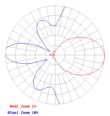
| Antenna Data for Antenna Id: 1009878 WSB-TV LD File: -0000197030 Kathrein - 2x1 750 10213 Service: LD Standard Pattern: N Pattern and Field Values Include a 93° Clockwise Rotation |  | ||||||||||||||||||||||||||||||||||||||||||||||||||||||||||||
| Azimuth | Ratio | Azimuth | Ratio | Azimuth | Ratio | Azimuth | Ratio | ||||||||||||||||||||||||||||||||||||||||||||||||||||||
| 3 | 0.063 | 13 | 0.106 | 23 | 0.186 | 33 | 0.293 | ||||||||||||||||||||||||||||||||||||||||||||||||||||||
| 43 | 0.435 | 53 | 0.588 | 63 | 0.742 | 73 | 0.873 | ||||||||||||||||||||||||||||||||||||||||||||||||||||||
| 83 | 0.967 | 93 | 1.000 | 103 | 0.966 | 113 | 0.871 | ||||||||||||||||||||||||||||||||||||||||||||||||||||||
| 123 | 0.742 | 133 | 0.585 | 143 | 0.429 | 153 | 0.294 | ||||||||||||||||||||||||||||||||||||||||||||||||||||||
| 163 | 0.186 | 173 | 0.110 | 183 | 0.069 | 193 | 0.068 | ||||||||||||||||||||||||||||||||||||||||||||||||||||||
| 203 | 0.077 | 213 | 0.077 | 223 | 0.061 | 233 | 0.028 | ||||||||||||||||||||||||||||||||||||||||||||||||||||||
| 243 | 0.021 | 253 | 0.061 | 263 | 0.090 | 273 | 0.103 | ||||||||||||||||||||||||||||||||||||||||||||||||||||||
| 283 | 0.089 | 293 | 0.057 | 303 | 0.013 | 313 | 0.029 | ||||||||||||||||||||||||||||||||||||||||||||||||||||||
| 323 | 0.060 | 333 | 0.074 | 343 | 0.073 | 353 | 0.061 | ||||||||||||||||||||||||||||||||||||||||||||||||||||||
Structure Registration Number 1054558 Structure Type: GTOWER Registered To: American Towers LLC Structure Address: 1129 Loganville Highway Bold Springs, GA County Name: Barrow County ASR Issued: 01/05/2021 Date Built: 09/29/1999 Site Elevation: 262.1 m (860 ft.) Structure Height: 315.5 m (1035 ft.) Height Overall: 315.5 m (1035 ft.) Overall Height AMSL: 577.6 m (1895 ft.) FAA Determination: 09/11/2017 FAA Study #: 2017-ASO-18443-OE FAA Circular #: 70/7460-1L Paint & Light FAA Chapters: 4, 9, 12 PRIOR STUDY 1999-ASO-2073-OE 33-55-51.3 N 83-46-59.3 W (NAD 83) 33-55-50.9 N 83-46-59.7 W (Converted to NAD 27) |
1601 W. Peachtree Street, NE Atlanta, GA 30309 Phone: 404-897-7000 Limited Liability Company | Title: Vice President and Secretary Date: 08/04/2022 Application Certifier Georgia Television, LLC Georgia Television, LLC 1601 W. Peachtree Street, NE Atlanta, GA 30309 Applicant Christina Burrow Cooley LLP 1299 Pennsylvania Avenue, NW Suite 700 Washington, DC 20004 Legal Representative | |||||||||||||||||||||||||||||||||||||||||||||||||||||||||||
|
| ||||||||||||||||||||||||||||||||||||||||||||||||||||||||||||