FCCInfo.com
A Service of Cavell, Mertz & Associates, Inc.
(855) FCC-INFO
|
|
KADF-LP from 09/05/2002 K20EP from 11/24/1993 930402RK from ??? |
|
|
|||||||||||||||||||
|
|
KADF-LD is a channel sharing guest of KADF-LD, Austin, Texas KADF-LD, Austin, Texas Status: LIC Application Accepted: 08/11/2022 License Expires: 08/01/2030 File Number: 0000197433 FCC Website Links: LMS Facility Details This Application Other KADF-LD Applications Including Superseded Applications Service Contour - Open Street Map or USGS Map (51 dBu) Service Contour - KML / Google Earth (51 dBu) Rabbit Ears Info Search for KADF-LD Site Location: 30-19-21.0 N 97-48-04.0 W (NAD 83) Site Location: 30-19-20.3 N 97-48-03.0 W (Converted to NAD 27) ERP: 15 kW Polarization: Horizontally polarized R/C AGL: 172 m (564 ft.) R/C AMSL: 409.8 m (1344 ft.) Emission Mask: Full Service Site Elevation: 237.8 m. (780 ft.) Height Overall*: 284.4 m (933 ft.) (* As Filed In This Application, may differ from ASR Data, Below.) Directional Antenna - Antenna Make/Model: Andrew ALP24L3-HSM Antenna ID: 16703 Polarization: Horizontally polarized
| |||||||||||||||||||||
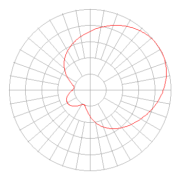
| Antenna Data for Antenna Id: 16703 KADF-LD LD File: -0000197433 Andrew - ALP24L3-HSM Service: LD Standard Pattern: Y Pattern and Field Values Include a 60° Clockwise Rotation |  | |||||||||||||||||||||
| Azimuth | Ratio | Azimuth | Ratio | Azimuth | Ratio | Azimuth | Ratio | |||||||||||||||
| 0 | 0.723 | 10 | 0.785 | 20 | 0.848 | 30 | 0.907 | |||||||||||||||
| 40 | 0.956 | 50 | 0.989 | 60 | 1.000 | 70 | 0.989 | |||||||||||||||
| 80 | 0.956 | 90 | 0.907 | 100 | 0.848 | 110 | 0.785 | |||||||||||||||
| 120 | 0.723 | 130 | 0.667 | 140 | 0.612 | 150 | 0.554 | |||||||||||||||
| 160 | 0.489 | 170 | 0.413 | 180 | 0.328 | 190 | 0.247 | |||||||||||||||
| 200 | 0.200 | 210 | 0.214 | 220 | 0.262 | 230 | 0.306 | |||||||||||||||
| 240 | 0.322 | 250 | 0.306 | 260 | 0.262 | 270 | 0.214 | |||||||||||||||
| 280 | 0.200 | 290 | 0.247 | 300 | 0.328 | 310 | 0.413 | |||||||||||||||
| 320 | 0.489 | 330 | 0.554 | 340 | 0.612 | 350 | 0.667 | |||||||||||||||
Structure Registration Number 1063584 Structure Type: TOWER Registered To: WESTLAKE TOWER, INC. Structure Address: 2724g Trail Of The Madrones Austin, TX County Name: Travis County ASR Issued: 04/23/1999 Date Built: 03/15/1990 Site Elevation: 237.8 m (780 ft.) Structure Height: 256.1 m (840 ft.) Height Overall: 284.4 m (933 ft.) Overall Height AMSL: 522.2 m (1713 ft.) FAA Determination: 05/03/1989 FAA Study #: 88-ASW-1844-OE Paint & Light FAA Chapters: 1, 3, 6, 15, 21 30-19-21.0 N 97-48-04.0 W (NAD 83) 30-19-20.3 N 97-48-03.0 W (Converted to NAD 27) |
38955 Hills Tech Dr. Farmington Hills, MI 48331 Phone: 248-536-0776 Limited Liability Company | Title: Individual Licensee Date: 08/11/2022 Application Certifier P.O. Box 10310 Prescott, AZ 86304 Applicant Cary S. Tepper Tepper Law Firm, LLC 4900 Auburn Avenue Suite 100 Bethesda, MD 20814 Communications Counsel | ||||||||||||||||||||