FCCInfo.com
A Service of Cavell, Mertz & Associates, Inc.
(855) FCC-INFO
|
|
WXNE-TV from 02/28/1979 WXNE from ??? |
Virtual Channel 25 |  |
|
||||||||||||||||||||||||||||||
|
|
Status: LIC Application Accepted: 12/07/2022 License Expires: 04/01/2031 File Number: 0000204191 FCC Website Links: LMS Facility Details This Application Other WFXT Applications Including Superseded Applications Service Contour - Open Street Map or USGS Map (41 dBu) Service Contour - KML / Google Earth (41 dBu) Public Inspection Files Rabbit Ears Info Search for WFXT Site Location: 42-18-10.7 N 71-13-04.9 W (NAD 83) Site Location: 42-18-10.3 N 71-13-06.7 W (Converted to NAD 27) ERP: 1000 kW Polarization: Elliptically polarized HAAT: 350 m (1148 ft.) Electrical Beam Tilt: 0.75 degrees R/C AGL: 347 m (1138 ft.) R/C AMSL: 393 m (1289 ft.) Site Elevation: 46 m. (151 ft.) Height Overall*: 366 m (1201 ft.) (* As Filed In This Application, may differ from ASR Data, Below.) Directional Antenna - Antenna Make/Model: DIELECTRIC TUM-AP-O4-14/56H-2-B Antenna ID: 1010293 Polarization: Elliptically polarized | |||||||||||||||||||||||||||||||||
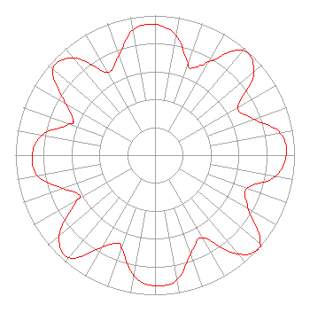
| Antenna Data for Antenna Id: 1010293 WFXT DT File: -0000204191 DIELECTRIC - TUM-AP-O4-14/56H-2-B Service: DT Standard Pattern: N |  | |||||||||||||||||||||||||||||||||
| Azimuth | Ratio | Azimuth | Ratio | Azimuth | Ratio | Azimuth | Ratio | |||||||||||||||||||||||||||
| 0 | 0.936 | 10 | 0.872 | 20 | 0.697 | 23 | 0.678 | |||||||||||||||||||||||||||
| 30 | 0.773 | 40 | 0.979 | 50 | 0.924 | 60 | 0.685 | |||||||||||||||||||||||||||
| 70 | 0.754 | 80 | 0.913 | 90 | 0.941 | 100 | 0.877 | |||||||||||||||||||||||||||
| 110 | 0.701 | 120 | 0.775 | 130 | 0.980 | 133 | 1.000 | |||||||||||||||||||||||||||
| 140 | 0.923 | 150 | 0.683 | 160 | 0.750 | 170 | 0.908 | |||||||||||||||||||||||||||
| 180 | 0.937 | 190 | 0.877 | 200 | 0.706 | 203 | 0.686 | |||||||||||||||||||||||||||
| 210 | 0.768 | 220 | 0.959 | 230 | 0.896 | 240 | 0.647 | |||||||||||||||||||||||||||
| 243 | 0.616 | 250 | 0.703 | 260 | 0.855 | 270 | 0.881 | |||||||||||||||||||||||||||
| 280 | 0.822 | 290 | 0.654 | 293 | 0.639 | 300 | 0.742 | |||||||||||||||||||||||||||
| 310 | 0.955 | 320 | 0.908 | 330 | 0.686 | 340 | 0.757 | |||||||||||||||||||||||||||
| 350 | 0.910 | |||||||||||||||||||||||||||||||||
Structure Registration Number 1004233 Structure Type: GTOWER Registered To: American Towers LLC Structure Address: 140 Cabot St ( 005760 ) Needham, MA County Name: Norfolk County ASR Issued: 07/07/2014 Date Built: 04/19/2005 Site Elevation: 46 m (151 ft.) Structure Height: 335.6 m (1101 ft.) Height Overall: 366 m (1201 ft.) Overall Height AMSL: 412 m (1352 ft.) FAA Determination: 06/30/2014 FAA Study #: 2014-ANE-121-OE FAA Circular #: 70/7460-1K Paint & Light FAA Chapters: 3, 4, 5, 12 OM&L to remain the same as prior study = PAINT/RED LIGHTS 42-18-10.7 N 71-13-04.9 W (NAD 83) 42-18-10.3 N 71-13-06.7 W (Converted to NAD 27) |
1601 W. Peachtree Street, NE Atlanta, GA 30309 Phone: 404-897-7000 Limited Liability Company | Title: Vice President and Secretary Date: 12/07/2022 Application Certifier Teton Opco Corp. 1601 W. Peachtree Street, NE Atlanta, GA 30309 Applicant Christina Burrow Cooley LLP 1299 Pennsylvania Avenue, NW Suite 700 Washington, DC 20004 Legal Representative | ||||||||||||||||||||||||||||||||
|
| |||||||||||||||||||||||||||||||||