|
W300CO Channel: 300D 107.9 MHz
Dexter, Michigan
Service: FX - A translator or application for a translator.
Facility ID: 145494
FRN: 0022644066
Fac. Service: FX
Programming Delivery Method: Unspecified
Status: LIC
Application Accepted: 12/21/2022
Application Granted: 01/04/2023
File Number: 0000205816
License Expires: 10/01/2028
Application Type: License To Cover
FCC Website Links:
LMS Facility Details
This Application
Other W300CO Applications
Including Superseded Applications
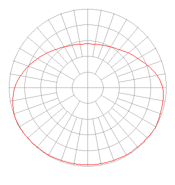
Service Contour - Open Street Map or USGS Map (60 dBu)
Service Contour - KML / Google Earth (60 dBu)
Facility Type: NON-COMMERCIAL EDUC. FM
Class: D, A Noncommercial educational operating with no more than 10W
Site Location: 42-14-46.5 N 83-50-58.0 W (NAD 83)
Site Location: 42-14-46.4 N 83-50-58.2 W (Converted to NAD 27)
Effective Radiated Power: 0.1 kW
Transmitter Output Power: 0.313 kW
Antenna Center AMSL: 349 m (1145 ft.)
Antenna Center HAG: 59 m (194 ft.)
Site Elevation: 290 m. (951 ft.)
Height Overall*: 121.9 m (400 ft.)
(* As Filed In This Application, may differ from ASR Data, Below.)
Directional Antenna
Antenna Make/Model: Nicom BKG77
Antenna ID: 115734
Polarization: H
| Primary Station |
| WJKN-FM |
Ch. 207 | Spring Arbor, Michigan |
|
Structure Information
Structure Registration Number 1275265
Structure Type: GTOWER
Registered To:
SBA Towers II LLC
Structure Address:
6634 W. Waters Rd. (mi12555-s)
Ann Arbor, MI
County Name: Washtenaw County
ASR Issued: 05/19/2017
Date Built: 03/30/2011
Site Elevation: 290 m (951 ft.)
Structure Height: 120 m (394 ft.)
Height Overall: 121.9 m (400 ft.)
Overall Height AMSL: 411.9 m (1351 ft.)
FAA Determination: 05/15/2017
FAA Study #: 2017-AGL-6426-OE
FAA Circular #: 70/7460-1L
Paint & Light FAA Chapters: 4, 8, 12
PRIOR STUDY 2010-AGL-2771-OE
42-14-46.5 N 83-50-58.0 W (NAD 83)
42-14-46.4 N 83-50-58.2 W
(Converted to NAD 27)
|
W300CO(FX) Licensee Information
Ave Maria Communications
Post Office Box 504
Ann Arbor, MI 48106
Phone: 734-930-3167
Corporation | 0000205816 Applicant Information
Michael P. Jones
Title: Vice-President
Date: 12/21/2022
Application Certifier
Spring Arbor University
Ave Maria Communications
Post Office Box 504
Ann Arbor, MI 48106
Applicant
Bruce Bellamy
Munn-Reese
PO Box 220
Coldwater, MI 49036
Consulting Engineer
Dennis J. Kelly
Law Office of Dennis J. Kelly
30628 Detroit Road, Box 278
Westlake, OH 44145
Attorney
|