FCCInfo.com
A Service of Cavell, Mertz & Associates, Inc.
(855) FCC-INFO
|
|
KDTV from ??? |
Virtual Channel 14 |
|
|||||||||||||||||||||||||
|
|
KDTV-DT is a channel sharing host for KTSF, San Francisco, California Status: LIC Application Accepted: 03/09/2023 License Expires: 12/01/2022 File Number: 0000212320 FCC Website Links: LMS Facility Details This Application Other KDTV-DT Applications Including Superseded Applications Service Contour - Open Street Map or USGS Map (41 dBu) Service Contour - KML / Google Earth (41 dBu) Public Inspection Files Rabbit Ears Info Search for KDTV-DT Site Location: 37-29-57.0 N 121-52-20.0 W (NAD 83) Site Location: 37-29-57.2 N 121-52-16.2 W (Converted to NAD 27) ERP: 475 kW Polarization: Elliptically polarized HAAT: 701.3 m (2301 ft.) Electrical Beam Tilt: 1.5 degrees R/C AGL: 126.7 m (416 ft.) R/C AMSL: 921 m (3022 ft.) Site Elevation: 794.3 m. (2606 ft.) Height Overall*: 135 m (443 ft.) (* As Filed In This Application, may differ from ASR Data, Below.) Directional Antenna - Antenna Make/Model: R.F. Systems SAA20-KDTV-E600-ET5R-20 Antenna ID: 1010530 Polarization: Elliptically polarized | |||||||||||||||||||||||||||
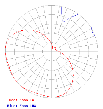
| Antenna Data for Antenna Id: 1010530 KDTV-DT DT File: -0000212320 R.F. Systems - SAA20-KDTV-E600-ET5R-20 Service: DT Standard Pattern: N |  | |||||||||||||||||||||||||||
| Azimuth | Ratio | Azimuth | Ratio | Azimuth | Ratio | Azimuth | Ratio | |||||||||||||||||||||
| 0 | 0.170 | 10 | 0.110 | 20 | 0.070 | 30 | 0.085 | |||||||||||||||||||||
| 40 | 0.110 | 45 | 0.125 | 50 | 0.120 | 60 | 0.100 | |||||||||||||||||||||
| 70 | 0.100 | 80 | 0.120 | 90 | 0.170 | 100 | 0.242 | |||||||||||||||||||||
| 110 | 0.338 | 120 | 0.459 | 130 | 0.595 | 140 | 0.728 | |||||||||||||||||||||
| 150 | 0.846 | 160 | 0.933 | 170 | 0.977 | 180 | 0.980 | |||||||||||||||||||||
| 190 | 0.961 | 200 | 0.953 | 210 | 0.970 | 220 | 0.992 | |||||||||||||||||||||
| 227 | 0.998 | 230 | 0.997 | 240 | 0.982 | 250 | 0.972 | |||||||||||||||||||||
| 260 | 0.982 | 270 | 0.999 | 273 | 1.000 | 280 | 0.990 | |||||||||||||||||||||
| 290 | 0.939 | 300 | 0.845 | 310 | 0.724 | 320 | 0.588 | |||||||||||||||||||||
| 330 | 0.454 | 340 | 0.335 | 350 | 0.241 | |||||||||||||||||||||||
Structure Registration Number 1044718 [ASR Heights Differ from KDTV-DT Application] Structure Type: GTOWER Registered To: SBA Towers XI, LLC Structure Address: Mount Allison 3 Mi E 9526 Weller Road (ca1899d-a) Fremont, CA County Name: Alameda County ASR Issued: 01/03/2025 Date Built: 02/25/1998 Site Elevation: 794.3 m (2606 ft.) Structure Height: 115.8 m (380 ft.) Height Overall: 122.8 m (403 ft.) Overall Height AMSL: 917.1 m (3009 ft.) FAA Determination: 12/18/2024 FAA Study #: 2024-AWP-13707-OE FAA Circular #: 70/7460-1J Paint & Light FAA Chapters: 8, 13 OM&L to remain the same as prior study = A MED-DUAL SYSTEM 37-29-57.7 N 121-52-20.7 W (NAD 83) 37-29-57.9 N 121-52-16.9 W (Converted to NAD 27) |
8551 NW 30th Terrace Miami, FL 33122 Phone: 310-348-3600 General Partnership | Title: Senior Vice President US Regulatory Date: 03/09/2023 Application Certifier KDTV License Partnership, G.P. KDTV License Partnership, G.P. 101 Constitution Avenue, NW, Suite 800W Washington, DC 20001 Applicant Greg Coburn Televisaunivision 101 Constitution Ave NE Washington, DC 20001 Director Nextgen TV Matthew S. Delnero Covington & Burling LLP. One Citycenter 850 Tenth Street NW Washington, DC 20001 | ||||||||||||||||||||||||||
|
| |||||||||||||||||||||||||||