FCCInfo.com
A Service of Cavell, Mertz & Associates, Inc.
(855) FCC-INFO
|
|
KOKI from 12/12/1979 780907KG from ??? |
Virtual Channel 23 |
|
|||||||||||||||||||||||||||||||||||||
|
|
Status: LIC Application Accepted: 06/06/2023 License Expires: 06/01/2030 File Number: 0000216270 FCC Website Links: LMS Facility Details This Application Other KOKI-TV Applications Including Superseded Applications Service Contour - Open Street Map or USGS Map (41 dBu) Service Contour - KML / Google Earth (41 dBu) Public Inspection Files Rabbit Ears Info Search for KOKI-TV Site Location: 35-58-08.0 N 95-36-56.0 W (NAD 83) Site Location: 35-58-07.6 N 95-36-55.1 W (Converted to NAD 27) ERP: 782.6 kW Polarization: Horizontally polarized HAAT: 509 m (1670 ft.) Electrical Beam Tilt: 0.5 degrees R/C AGL: 496.8 m (1630 ft.) R/C AMSL: 692.8 m (2273 ft.) Site Elevation: 196 m. (643 ft.) Height Overall*: 581.8 m (1909 ft.) (* As Filed In This Application, may differ from ASR Data, Below.) Directional Antenna - Antenna Make/Model: DIELECTRIC TFU-24WB-R S260 OS-521 Antenna ID: 1009712 Polarization: Horizontally polarized | |||||||||||||||||||||||||||||||||||||||
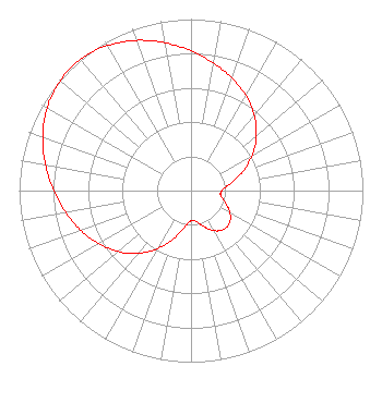
| Antenna Data for Antenna Id: 1009712 KOKI-TV DX File: -0000216270 DIELECTRIC - TFU-24WB-R S260 OS-521 Service: DX Standard Pattern: Y Pattern and Field Values Include a 316° Clockwise Rotation |  | |||||||||||||||||||||||||||||||||||||||
| Azimuth | Ratio | Azimuth | Ratio | Azimuth | Ratio | Azimuth | Ratio | |||||||||||||||||||||||||||||||||
| 6 | 0.779 | 16 | 0.721 | 26 | 0.662 | 36 | 0.600 | |||||||||||||||||||||||||||||||||
| 46 | 0.528 | 56 | 0.446 | 66 | 0.356 | 76 | 0.265 | |||||||||||||||||||||||||||||||||
| 86 | 0.194 | 96 | 0.172 | 106 | 0.197 | 116 | 0.244 | |||||||||||||||||||||||||||||||||
| 126 | 0.283 | 136 | 0.297 | 146 | 0.283 | 156 | 0.245 | |||||||||||||||||||||||||||||||||
| 166 | 0.198 | 176 | 0.172 | 186 | 0.194 | 196 | 0.264 | |||||||||||||||||||||||||||||||||
| 206 | 0.355 | 216 | 0.444 | 226 | 0.525 | 236 | 0.592 | |||||||||||||||||||||||||||||||||
| 246 | 0.657 | 256 | 0.716 | 266 | 0.774 | 276 | 0.835 | |||||||||||||||||||||||||||||||||
| 286 | 0.895 | 296 | 0.948 | 306 | 0.986 | 316 | 1.000 | |||||||||||||||||||||||||||||||||
| 326 | 0.988 | 336 | 0.952 | 346 | 0.899 | 356 | 0.839 | |||||||||||||||||||||||||||||||||
Structure Registration Number 1010985 Structure Type: TOWER Registered To: KTUL Licensee, LLC Structure Address: 13455 S 321st E Ave Coweta, OK County Name: Wagoner County ASR Issued: 01/11/2017 Date Built: 01/01/1988 Site Elevation: 196 m (643 ft.) Structure Height: 551.3 m (1809 ft.) Height Overall: 581.8 m (1909 ft.) Overall Height AMSL: 777.8 m (2552 ft.) Paint & Light FAA Chapters: 1, 3, 10.2, 19.2, 21 35-58-08.0 N 95-36-56.0 W (NAD 83) 35-58-07.6 N 95-36-55.1 W (Converted to NAD 27) |
301 S. McDowell Street Suite 125 #1645 Charlotte, NC 28204 Phone: 202-663-8166 Limited Liability Company | Title: Senior Vice President, Legal and Business Affairs Date: 06/06/2023 Application Certifier Imagicomm Tulsa, LLC 3000 Worldreach Drive Indian Land, SC 29707 Applicant S Merrill Weiss Merrill Weiss Group LLC 227 Central Avenue Metuchen, NJ 08840-1242 President Christina Burrow Cooley LLP 1299 Pennsylvania Avenue, N.W. Suite 700 Washington, DC 20004 Legal Representative | ||||||||||||||||||||||||||||||||||||||
|
| |||||||||||||||||||||||||||||||||||||||