FCCInfo.com
A Service of Cavell, Mertz & Associates, Inc.
(855) FCC-INFO
|
|
KSDW from 09/26/1989 KSDW from 08/24/1984 KSDW from 11/05/1979 |
|  |
|
||||||||||||||||||
|
|
KSDW Channel: 205B 88.9 MHz Temecula, California Service: FM - A full-service FM station or application. Facility ID: 52141 FRN: 0007309255 Fac. Service: FM Status: STA – Special Temporary Authority Application Accepted: 08/22/2023 Application Granted: 08/23/2023 File Number: 0000219739 STA Expires: 12/01/2029 Application Type: Engineering Special Temporary Authority FCC Website Links: LMS Facility Details This Application Other KSDW Applications Other KSDW Applications in CDBS Including Superseded Applications Mailing Address Correspondence for KSDW Correspondence related to application 0000219739 Service Contour - Open Street Map or USGS Map (60 dBu) Service Contour - KML / Google Earth (60 dBu) Public Inspection Files History Cards for KSDW Facility Type: NON-COMMERCIAL EDUC. FM Class: B, A Zone I or I-A station; with 25kW-50kW ERP and a class contour distance 39km-52km Site Location: 33-00-32.1 N 116-58-20.0 W (NAD 83) Site Location: 33-00-31.9 N 116-58-16.9 W (Converted to NAD 27) Effective Radiated Power: 0 kW Horiz. ; 0.9 kW Vert. Antenna Center HAAT: 0 m Horiz.; 535 m Vert. Antenna Center AMSL: 0 m Horiz.; 881.4 m Vert. Antenna Center HAG: 0 m Horiz.; 17 m Vert. Site Elevation: 864.4 m. (2836 ft.) Height Overall*: 30.5 m (100 ft.) (* As Filed In This Application, may differ from ASR Data, Below.) Directional Antenna Antenna Make/Model: None Antenna ID: 103819 Polarization:
| |||||||||||||||||||||
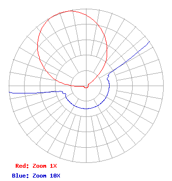
| Antenna Data for Antenna Id: 103819 KSDW FM File: -0000219739 None - Service: FM |  | |||||||||||||||||||||
| Azimuth | Ratio | Azimuth | Ratio | Azimuth | Ratio | Azimuth | Ratio | |||||||||||||||
| 0 | 0.916 | 10 | 0.817 | 20 | 0.690 | 30 | 0.544 | |||||||||||||||
| 40 | 0.390 | 50 | 0.190 | 60 | 0.050 | 70 | 0.030 | |||||||||||||||
| 80 | 0.030 | 90 | 0.030 | 100 | 0.030 | 110 | 0.030 | |||||||||||||||
| 120 | 0.030 | 130 | 0.030 | 140 | 0.030 | 150 | 0.030 | |||||||||||||||
| 160 | 0.030 | 170 | 0.030 | 180 | 0.030 | 190 | 0.030 | |||||||||||||||
| 200 | 0.030 | 210 | 0.030 | 220 | 0.030 | 230 | 0.030 | |||||||||||||||
| 240 | 0.030 | 250 | 0.030 | 260 | 0.050 | 270 | 0.190 | |||||||||||||||
| 280 | 0.390 | 290 | 0.544 | 300 | 0.690 | 310 | 0.817 | |||||||||||||||
| 320 | 0.916 | 330 | 0.980 | 340 | 1.000 | 350 | 0.980 | |||||||||||||||
Structure Registration Number 1299659 Structure Type: LTOWER Registered To: Palomar Communications, Inc. Structure Address: 17138 Mt. Woodson Road Ramona, CA County Name: San Diego County ASR Issued: 07/20/2017 Date Built: 06/01/2017 Site Elevation: 864.4 m (2836 ft.) Structure Height: 24.7 m (81 ft.) Height Overall: 30.5 m (100 ft.) Overall Height AMSL: 894.9 m (2936 ft.) FAA Determination: 06/16/2016 FAA Study #: 2016-AWP-4593-OE Paint & Light FAA Chapters: NONE 33-00-32.1 N 116-58-20.0 W (NAD 83) 33-00-31.9 N 116-58-16.9 W (Converted to NAD 27) |
3000 W. MacArthur Blvd. Suite 500 Santa Ana, CA 92704 Phone: 714-918-6207 Not-for-Profit | Title: President Date: 08/22/2023 Application Certifier Calvary Chapel of Costa Mesa, Inc. Calvary Chapel of Costa Mesa, Inc. 3000 W. MacArthur Blvd. Suite 500 Santa Ana, CA 92704 Applicant Mark A. Balkin Hardy, Carey, Chautin & Balkin, LLP 1080 West Causeway Approach Mandeville, LA 70471 Robert Branch, Jr. CTM 440 Astillero Street Las Vegas, NV 89138 Technical Consultant | ||||||||||||||||||||
| ||||||||||||||||||||||