|
K291DA Channel: 291D 106.1 MHz
San Antonio, Texas
Service: FX - A translator or application for a translator.
Facility ID: 148519
FRN: 0024633679
Fac. Service: FX
Programming Delivery Method: Unspecified
Status: CP
Application Accepted: 08/31/2023
Application Granted: 10/02/2023
File Number: 0000220242
K291DA CP Expires: 10/02/2026
Application Type: Minor Modification
FCC Website Links:
LMS Facility Details
This Application
Other K291DA Applications
Including Superseded Applications
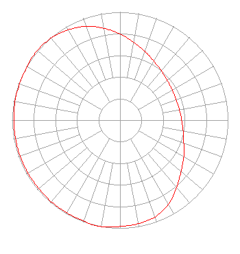
Service Contour - Open Street Map or USGS Map (60 dBu)
Service Contour - KML / Google Earth (60 dBu)
Facility Type: NON-COMMERCIAL EDUC. FM
Class: D, A Noncommercial educational operating with no more than 10W
Site Location: 29-22-59.2 N 98-38-14.9 W (NAD 83)
Site Location: 29-22-58.4 N 98-38-13.8 W (Converted to NAD 27)
Effective Radiated Power: 0.16 kW
Antenna Center AMSL: 290.7 m Horiz.; 300.7 m Vert. (954 ft. Horiz. / 987 ft. Vert.)
Antenna Center HAG: 50 m Horiz.; 60 m Vert. (164 ft. Horiz. / 197 ft. Vert.)
Site Elevation: 240.7 m. (790 ft.)
Height Overall*: 76.2 m (250 ft.)
(* As Filed In This Application, may differ from ASR Data, Below.)
Directional Antenna
Antenna Make/Model: Nicom BKG-77 (3 Bay HW)
Antenna ID: 0
Polarization: H
| Primary Station |
| KZIC(FM) |
Ch. 210 | Hondo, Texas |
|
Structure Information
Structure Registration Number 1265408
Structure Type: TOWER
Registered To:
OE Investments
Structure Address:
Cedar Hurt Dr. & Springdale Dr.
San Antonio, TX
County Name: Bexar County
ASR Issued: 10/02/2008
Date Built: 12/06/2002
Site Elevation: 240.7 m (790 ft.)
Structure Height: 73.1 m (240 ft.)
Height Overall: 76.2 m (250 ft.)
Overall Height AMSL: 316.9 m (1040 ft.)
FAA Determination: 09/26/2008
FAA Study #: 2008-ASW-6224-OE
FAA Circular #: 70/7460-1K
Paint & Light FAA Chapters: 3, 4, 5, 12
PRIOR STUDY 2003-ASW-6728-OE
29-22-59.2 N 98-38-14.9 W (NAD 83)
29-22-58.4 N 98-38-13.8 W
(Converted to NAD 27)
|
K291DA(FX) Licensee Information
AF Group, LLC
305 E Ramsey Rd.
Suite # 26
San Antonio, TX 78216
Phone: 830-370-2085
Limited Liability Company | 0000220242 Applicant Information
Christian Gaspar
Title: Managing Member
Date: 08/31/2023
Application Certifier
AF Group, LLC
AF Group, LLC
305 E Ramsey Rd.
Suite # 26
San Antonio, TX 78216
Applicant
Darryl K Delawder
Delawder Communications, Inc.
P. O. Box 1095
Ashburn, VA 20146-1095
President
Aaron P Shainis
Shainis & Peltzman, Chartered
1850 M Street NW
Suite 240
Washington, DC 20036
Legal Counsel
|