Accept
By using FCCInfo you agree to the terms & conditions. Read disclaimer Read privacy statement
FCCInfo.com

A Service of Cavell, Mertz & Associates, Inc.
(855) FCC-INFO

KFPH-CD
Call Sign History
KFPH-CD from 08/10/2011
KFPH-CA from 01/04/2002
KOND-LP from 08/07/2001
KDTP-LP from 12/16/1998
K39BI from 12/16/1986
810116MY from ???
Channel 35DT
Virtual Channel 35

Phoenix, AZ
License
CP
Application
Allocation
STA


KFPH-CD Service: DC - Digital Class A Television Station (ATSC3 Station)
Channel: 35 Zone:
Phoenix, Arizona
Nielsen DMA™:  Phoenix (Prescott)
Network: UniMas
Virtual Channel: 35
DTV TSID: 7035
Facility ID: 2739
FRN: 0006487789

Status: LIC
Application Accepted: 12/18/2023
License Expires: 10/01/2022
File Number: 0000233344

FCC Website Links:
  LMS Facility Details
  This Application
  Other KFPH-CD Applications
  Including Superseded Applications
  Service Contour - Open Street Map or USGS Map (51 dBu)
  Service Contour - KML / Google Earth (51 dBu)
  Public Inspection Files
  Rabbit Ears Info Search for KFPH-CD

Site Location: 33-20-00.0 N 112-03-49.0 W (NAD 83)
Site Location: 33-19-59.8 N 112-03-46.5 W (Converted to NAD 27)

ERP: 15 kW
Polarization: Horizontally polarized
R/C AGL: 58 m (190 ft.)
R/C AMSL: 859.6 m (2820 ft.)
Emission Mask: Stringent

Site Elevation: 801.6 m. (2630 ft.)
Height Overall*: 86 m (282 ft.)
(* As Filed In This Application, may differ from ASR Data, Below.)
Directional Antenna - Antenna Make/Model: Systems With Reliability Inc. SWLP16WL
Antenna ID: 24175
Polarization: Horizontally polarized

Antenna Data for Antenna Id: 24175
KFPH-CD DC File: -0000233344
Systems With Reliability Inc. - SWLP16WL
Service: DC
Standard Pattern: Y
Pattern and Field Values Include a 15° Clockwise Rotation
AzimuthRatioAzimuthRatioAzimuthRatioAzimuthRatio
51.000151.000251.000351.000
450.980550.950650.900750.820
850.720950.6201050.5001150.390
1250.2901350.2001450.1601550.150
1650.1601750.1701850.1801950.190
2050.1802150.1702250.1602350.150
2450.1602550.2002650.2902750.390
2850.5002950.6203050.7203150.820
3250.9003350.9503450.9803551.000
Structure Information

Structure Registration Number 1065157

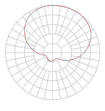
[ASR Heights Differ from KFPH-CD Application]
Structure Type: LTOWER
Registered To:
SBA Towers XI, LLC
Structure Address:
South Mountain (az1899a-a)
Phoenix, AZ
County Name: Maricopa County
ASR Issued: 01/03/2025
Date Built: 01/01/1979
Site Elevation: 812.3 m (2665 ft.)
Structure Height: 61 m (200 ft.)
Height Overall: 76.2 m (250 ft.)
Overall Height AMSL: 888.5 m (2915 ft.)
FAA Determination: 10/29/2024
FAA Study #: 2024-AWP-12703-OE
Paint & Light FAA Chapters: A1, H, 3, 11, 21, 23
PRIOR STUDY 1998-AWP-3076-OE
33-19-59.9 N 112-03-48.0 W (NAD 83)
33-19-59.7 N 112-03-45.5 W
(Converted to NAD 27)
KFPH-CD Licensee Information

Unimas Partnership of Phoenix
8551 NW 30th Terrace
Miami, FL 33122
Phone: 310-348-3600
Corporation
0000233344 Applicant Information

Karen Milne
Title: Senior Vice President US Regulatory
Date: 12/18/2023
Application Certifier
Unimas Partnership of Phoenix
101 Constitution Avenue, NW, Suite 800W
Washington, DC 20001
Applicant
Matthew S. Delnero
Covington & Burling LLP
One Citycenter
850 Tenth Street NW
Washington, DC 20001

Associated Land Mobile Licenses


(No Records Found)
Associated Microwave Licenses


(No Records Found)

Study Date: 4/01/2025; Study Duration: 0.0665 Seconds.
Database Sources:
04/01/2025 FCC LMS,
4/1/2025 FCC ASR,
4/1/2025 FCC ULS Microwave, and
4/1/2025 FCC ULS Broadcast Land Mobile.


© 2025 Capitol Airspace Group, LLC.
Alexandria, Virginia


If you have questions or concerns about the station above please contact the station Licensee.
Comments and questions about FCCInfo can be emailed to: webmaster@fccinfo.com