FCCInfo.com
A Service of Cavell, Mertz & Associates, Inc.
(855) FCC-INFO
|
|
KWSD from 10/01/2003 KAUN from 04/11/1997 950317KM from ??? |
Virtual Channel 36 |
|
|||||||||||||||||||||||||
|
|
Status: LIC Application Accepted: 01/17/2024 License Expires: 04/01/2030 File Number: 0000235534 FCC Website Links: LMS Facility Details This Application Other KSFL-TV Applications Including Superseded Applications Service Contour - Open Street Map or USGS Map (41 dBu) Service Contour - KML / Google Earth (41 dBu) Public Inspection Files Rabbit Ears Info Search for KSFL-TV Site Location: 43-30-14.0 N 96-34-18.8 W (NAD 83) Site Location: 43-30-14.1 N 96-34-17.6 W (Converted to NAD 27) ERP: 36.9 kW Polarization: Horizontally polarized HAAT: 229.7 m (754 ft.) Electrical Beam Tilt: 1.0 degree R/C AGL: 245.9 m (807 ft.) R/C AMSL: 657.7 m (2158 ft.) Site Elevation: 411.8 m. (1351 ft.) Height Overall*: 274.3 m (900 ft.) (* As Filed In This Application, may differ from ASR Data, Below.) Directional Antenna - Antenna Make/Model: Dielectric TLP-16M Antenna ID: 1011402 Polarization: Horizontally polarized | |||||||||||||||||||||||||||
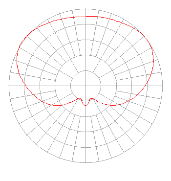
| Antenna Data for Antenna Id: 1011402 KSFL-TV DT File: -0000235534 Dielectric - TLP-16M Service: DT Standard Pattern: N |  | |||||||||||||||||||||||||||
| Azimuth | Ratio | Azimuth | Ratio | Azimuth | Ratio | Azimuth | Ratio | |||||||||||||||||||||
| 0 | 0.895 | 10 | 0.908 | 20 | 0.921 | 30 | 0.942 | |||||||||||||||||||||
| 40 | 0.974 | 50 | 0.995 | 60 | 0.985 | 70 | 0.940 | |||||||||||||||||||||
| 80 | 0.865 | 90 | 0.775 | 100 | 0.684 | 110 | 0.593 | |||||||||||||||||||||
| 120 | 0.497 | 130 | 0.392 | 140 | 0.280 | 150 | 0.197 | |||||||||||||||||||||
| 160 | 0.184 | 170 | 0.226 | 180 | 0.257 | 190 | 0.227 | |||||||||||||||||||||
| 200 | 0.183 | 210 | 0.194 | 220 | 0.278 | 230 | 0.393 | |||||||||||||||||||||
| 240 | 0.502 | 250 | 0.599 | 260 | 0.688 | 270 | 0.778 | |||||||||||||||||||||
| 280 | 0.873 | 290 | 0.951 | 300 | 0.993 | 307 | 1.000 | |||||||||||||||||||||
| 310 | 0.998 | 320 | 0.976 | 330 | 0.944 | 340 | 0.918 | |||||||||||||||||||||
| 350 | 0.901 | |||||||||||||||||||||||||||
Structure Registration Number 1206712 [ASR Heights Differ from KSFL-TV Application] Structure Type: GTOWER Registered To: Granite Tower Company, LLC Structure Address: 0.3 Km South Of State Hwy 38 Rowena, SD County Name: Minnehaha County ASR Issued: 02/27/2024 Date Built: 10/19/2020 Site Elevation: 411.8 m (1351 ft.) Structure Height: 237.7 m (780 ft.) Height Overall: 256 m (840 ft.) Overall Height AMSL: 667.8 m (2191 ft.) FAA Determination: 02/26/2024 FAA Study #: 2024-AGL-1641-OE FAA Circular #: 70/7460-1L Paint & Light FAA Chapters: 4, 9, 12 OM&L to remain the same as prior study = A HIGH-DUAL SYSTEM 43-30-14.0 N 96-34-18.8 W (NAD 83) 43-30-14.1 N 96-34-17.6 W (Converted to NAD 27) |
301 South 8th Street Fargo, ND 58103 Phone: 701-237-6500 Corporation | Title: Chief Operating Officer Date: 01/17/2024 Application Certifier Forum Communications Company 301 South 8th Street Fargo, ND 58103 Applicant Patrick Cross Brooks, Pierce Et Al. 150 Fayetteville Street Suite 1700 Raleigh, NC 27601 Tim Nelson Brooks, Pierce Et Al. 150 Fayetteville Street Suite 1700 Raleigh, NC 27601 | ||||||||||||||||||||||||||
| ||||||||||||||||||||||||||||