FCCInfo.com
A Service of Cavell, Mertz & Associates, Inc.
(855) FCC-INFO
|
|
KRRT from 08/29/1984 820416KE from ??? |
Virtual Channel 35 |
|
||||||||||||||||||||||
|
|
Status: LIC Application Accepted: 04/22/2024 License Expires: 08/01/2022 File Number: 0000243761 FCC Website Links: LMS Facility Details This Application Other KMYS Applications Including Superseded Applications Service Contour - Open Street Map or USGS Map (41 dBu) Service Contour - KML / Google Earth (41 dBu) Public Inspection Files Rabbit Ears Info Search for KMYS Site Location: 29-36-38.8 N 98-53-34.1 W (NAD 83) Site Location: 29-36-38.0 N 98-53-33.0 W (Converted to NAD 27) ERP: 1000 kW Polarization: Horizontally polarized HAAT: 530.8 m (1741 ft.) Electrical Beam Tilt: 1 degree R/C AGL: 465.4 m (1527 ft.) R/C AMSL: 921.4 m (3023 ft.) Site Elevation: 456 m. (1496 ft.) Height Overall*: 473.3 m (1553 ft.) (* As Filed In This Application, may differ from ASR Data, Below.) Directional Antenna - Antenna Make/Model: DIELECTRIC TFU-24GTH-R P270SP Antenna ID: 46137 Polarization: Horizontally polarized | ||||||||||||||||||||||||
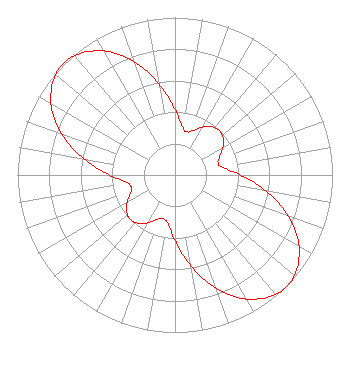
| Antenna Data for Antenna Id: 46137 KMYS DT File: -0000243761 DIELECTRIC - TFU-24GTH-R P270SP Service: DT Standard Pattern: Y |  | ||||||||||||||||||||||||
| Azimuth | Ratio | Azimuth | Ratio | Azimuth | Ratio | Azimuth | Ratio | ||||||||||||||||||
| 0 | 0.415 | 10 | 0.302 | 15 | 0.285 | 20 | 0.296 | ||||||||||||||||||
| 30 | 0.351 | 40 | 0.393 | 50 | 0.393 | 60 | 0.351 | ||||||||||||||||||
| 70 | 0.296 | 75 | 0.285 | 80 | 0.302 | 90 | 0.415 | ||||||||||||||||||
| 100 | 0.589 | 110 | 0.767 | 120 | 0.910 | 130 | 0.989 | ||||||||||||||||||
| 135 | 1.000 | 140 | 0.989 | 150 | 0.910 | 160 | 0.767 | ||||||||||||||||||
| 170 | 0.589 | 180 | 0.415 | 190 | 0.302 | 200 | 0.296 | ||||||||||||||||||
| 210 | 0.351 | 220 | 0.393 | 225 | 0.400 | 230 | 0.393 | ||||||||||||||||||
| 240 | 0.351 | 250 | 0.296 | 260 | 0.302 | 270 | 0.415 | ||||||||||||||||||
| 280 | 0.589 | 290 | 0.767 | 300 | 0.910 | 310 | 0.989 | ||||||||||||||||||
| 315 | 1.000 | 320 | 0.989 | 330 | 0.910 | 340 | 0.767 | ||||||||||||||||||
| 350 | 0.589 | ||||||||||||||||||||||||
Structure Registration Number 1052003 Structure Type: TOWER Registered To: Chesapeake Television Licensee, LLC Structure Address: 2.3 Mi Ene Of Int Sr 1283 & Sr 37 Lake Hills, TX County Name: Bandera County ASR Issued: 01/11/2017 Date Built: 01/01/1985 Site Elevation: 456 m (1496 ft.) Structure Height: 473.3 m (1553 ft.) Height Overall: 473.3 m (1553 ft.) Overall Height AMSL: 929.3 m (3049 ft.) FAA Determination: 03/06/2002 FAA Study #: 01-ASW-5721-OE FAA Circular #: 70/7460-1K Paint & Light FAA Chapters: 4, 9, 12 PRIOR STUDY 98-ASW-3101-OE 29-36-38.8 N 98-53-34.1 W (NAD 83) 29-36-38.0 N 98-53-33.0 W (Converted to NAD 27) |
PO Box 5120 Avon, CO 81620 Phone: 970-628-9881 Limited Liability Company | Title: President of Licensee's Sole Member Date: 04/22/2024 Application Certifier Deerfield Media (San Antonio) Licensee, LLC Deerfield Media (San Antonio) Licensee, LLC PO Box 5120 Avon, CO 81620 Applicant Kevin Fisher Smith and Fisher, LLC 4791 Wintergreen Court Woodbridge, VA 22192 Scott R. Flick, Esq Pillsbury Winthrop Shaw Pittman LLP 1200 Seventeenth Street, NW Washington, DC 20036 | |||||||||||||||||||||||
| |||||||||||||||||||||||||