FCCInfo.com
A Service of Cavell, Mertz & Associates, Inc.
(855) FCC-INFO
|
|
KSGA-LP from 04/03/2001 K59FV from 06/26/1995 K43CY from 06/26/1995 DK43CY from 04/21/1993 K43CY from 08/23/1989 |
|
|
||||||||||||||||
|
|
KSGA-LD is a channel sharing host for KVHD-LD, Los Angeles, California Status: STA – Special Temporary Authority (Licensed And Silent) Application Accepted: 08/19/2024 STA Expires: 12/01/2022 File Number: 0000251768 FCC Website Links: LMS Facility Details This Application Other KSGA-LD Applications Including Superseded Applications Service Contour - Open Street Map or USGS Map (43 dBu) Service Contour - KML / Google Earth (43 dBu) Rabbit Ears Info Search for KSGA-LD Site Location: 34-11-14.0 N 117-42-04.0 W (NAD 83) Site Location: 34-11-14.0 N 117-42-00.8 W (Converted to NAD 27) ERP: 0.7 kW Polarization: Horizontally polarized R/C AGL: 20 m (66 ft.) R/C AMSL: 1646 m (5400 ft.) Emission Mask: Full Service Site Elevation: 1626 m. (5335 ft.) Height Overall*: 67 m (220 ft.) (* As Filed In This Application, may differ from ASR Data, Below.) Directional Antenna - Antenna Make/Model: Scala CL-26 Antenna ID: 20783 Polarization: Horizontally polarized | ||||||||||||||||||
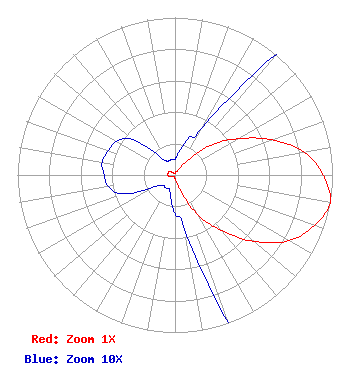
| Antenna Data for Antenna Id: 20783 KSGA-LD LD File: -0000251768 Scala - CL-26 Service: LD Standard Pattern: Y Pattern and Field Values Include a 100° Clockwise Rotation |  | ||||||||||||||||||
| Azimuth | Ratio | Azimuth | Ratio | Azimuth | Ratio | Azimuth | Ratio | ||||||||||||
| 0 | 0.010 | 10 | 0.015 | 20 | 0.025 | 30 | 0.035 | ||||||||||||
| 40 | 0.105 | 50 | 0.295 | 60 | 0.460 | 70 | 0.655 | ||||||||||||
| 80 | 0.835 | 90 | 0.940 | 100 | 1.000 | 110 | 0.940 | ||||||||||||
| 120 | 0.835 | 130 | 0.655 | 140 | 0.460 | 150 | 0.295 | ||||||||||||
| 160 | 0.105 | 170 | 0.035 | 180 | 0.025 | 190 | 0.015 | ||||||||||||
| 200 | 0.010 | 210 | 0.010 | 220 | 0.010 | 230 | 0.010 | ||||||||||||
| 240 | 0.015 | 250 | 0.035 | 260 | 0.043 | 270 | 0.045 | ||||||||||||
| 280 | 0.047 | 290 | 0.045 | 300 | 0.043 | 310 | 0.035 | ||||||||||||
| 320 | 0.015 | 330 | 0.010 | 340 | 0.010 | 350 | 0.010 | ||||||||||||
Structure Registration Number 1015693 Structure Type: LTOWER Registered To: Sunset Ridge, LLC Structure Address: Sunset Ridge Electronic Site Claremont, CA County Name: Los Angeles County ASR Issued: 03/21/2018 Date Built: 09/15/1982 Site Elevation: 1626 m (5335 ft.) Structure Height: 67 m (220 ft.) Height Overall: 67 m (220 ft.) Overall Height AMSL: 1693 m (5554 ft.) FAA Determination: 12/21/1981 FAA Study #: 81-AWP-767-OE Paint & Light FAA Chapters: NONE 34-11-14.0 N 117-42-04.0 W (NAD 83) 34-11-14.0 N 117-42-00.8 W (Converted to NAD 27) |
2323 Corinth Avenue Los Angeles, CA 90064 Phone: 310-943-5288 Limited Liability Company | Title: Manager Date: 08/19/2024 Application Certifier KJLA, LLC 2323 Corinth Avenue Los Angeles, CA 90064 Applicant Barry A. Friedman Thompson Hine LLP Suite 700 1919 M Street, NW Washington, DC 20036 James Stenberg Over the Air RF Consulting LLC 25 Stroudwater Road Portland, ME 04102 Principal Engineer | |||||||||||||||||