FCCInfo.com
A Service of Cavell, Mertz & Associates, Inc.
(855) FCC-INFO
|
|
WCEE from 06/17/1982 NEW00477 from ??? |
Virtual Channel 13 |
|
|||||||||||||||||||||||||
|
|
Status: STA – Special Temporary Authority (Licensed And Reduced Power) Application Accepted: 01/10/2025 STA Expires: 12/01/2029 File Number: 0000262601 FCC Website Links: LMS Facility Details This Application Other WPXS Applications Including Superseded Applications Service Contour - Open Street Map or USGS Map (36 dBu) Service Contour - KML / Google Earth (36 dBu) Public Inspection Files Rabbit Ears Info Search for WPXS Site Location: 38-21-53.6 N 89-53-23.5 W (NAD 83) Site Location: 38-21-53.4 N 89-53-23.1 W (Converted to NAD 27) ERP: 33.8 kW Polarization: Horizontally polarized HAAT: 163 m (535 ft.) R/C AGL: 104 m (341 ft.) R/C AMSL: 250.9 m (823 ft.) Emission Mask: Simple Site Elevation: 146.9 m. (482 ft.) Height Overall*: 114.3 m (375 ft.) (* As Filed In This Application, may differ from ASR Data, Below.) Directional Antenna - Antenna Make/Model: Systems With Reliability Inc. SWDDP Array Antenna ID: 1012437 Polarization: Horizontally polarized | |||||||||||||||||||||||||||
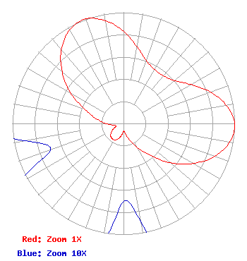
| Antenna Data for Antenna Id: 1012437 WPXS DT File: -0000262601 Systems With Reliability Inc. - SWDDP Array Service: DT Standard Pattern: N |  | |||||||||||||||||||||||||||
| Azimuth | Ratio | Azimuth | Ratio | Azimuth | Ratio | Azimuth | Ratio | |||||||||||||||||||||
| 0 | 0.830 | 10 | 0.700 | 20 | 0.600 | 30 | 0.560 | |||||||||||||||||||||
| 40 | 0.560 | 50 | 0.600 | 60 | 0.700 | 70 | 0.830 | |||||||||||||||||||||
| 80 | 0.940 | 90 | 1.000 | 100 | 0.970 | 110 | 0.870 | |||||||||||||||||||||
| 120 | 0.720 | 130 | 0.550 | 140 | 0.370 | 150 | 0.250 | |||||||||||||||||||||
| 160 | 0.160 | 170 | 0.090 | 180 | 0.070 | 190 | 0.110 | |||||||||||||||||||||
| 200 | 0.150 | 210 | 0.170 | 220 | 0.170 | 230 | 0.150 | |||||||||||||||||||||
| 240 | 0.110 | 250 | 0.070 | 260 | 0.090 | 270 | 0.160 | |||||||||||||||||||||
| 280 | 0.250 | 290 | 0.370 | 300 | 0.550 | 310 | 0.720 | |||||||||||||||||||||
| 320 | 0.870 | 330 | 0.970 | 340 | 1.000 | 350 | 0.940 | |||||||||||||||||||||
Structure Registration Number 1008634 Structure Type: LTOWER Registered To: American Towers LLC Structure Address: Five Forks Rd. & Hwy 13 (87674) New Athens, IL County Name: St. Clair County ASR Issued: 05/13/2025 Date Built: 12/07/1964 Site Elevation: 146.9 m (482 ft.) Structure Height: 106.7 m (350 ft.) Height Overall: 114.3 m (375 ft.) Overall Height AMSL: 261.2 m (857 ft.) FAA Determination: 02/15/2013 FAA Study #: 2013-AGL-288-OE FAA Circular #: 70/7460-1H Paint & Light FAA Chapters: 4, 6, 13 OM&L to remain the same as prior study = 24-HR MED-STROBES 38-21-53.6 N 89-53-23.5 W (NAD 83) 38-21-53.4 N 89-53-23.1 W (Converted to NAD 27) |
3901 Highway 121 S Bedford, TX 76021 Phone: 817-571-1229 Not-for-Profit | Title: Manager Date: 01/10/2025 Application Certifier Word of God Fellowship, Inc. Word of God Fellowship, Inc. 3901 Highway 121 S Bedford, TX 76021 Applicant Mark B Denbo Smithwick & Belendiuk, P.C. 5028 Wisconsin Ave Ste 301 Washington, DC 20016 Richard C Goetz R & L Media Systems 135 N Country Club Dr Hendersonville, TN 37075 Broadcast Consultant | ||||||||||||||||||||||||||
|
| |||||||||||||||||||||||||||