FCCInfo.com
A Service of Cavell, Mertz & Associates, Inc.
(855) FCC-INFO
|
|
KFDM-TV from 05/08/1980 KFDM from ??? |
Virtual Channel 6 |  |
|
||||||||||||||||||||||||||||||
|
|
Status: LIC Application Accepted: 02/28/2025 License Expires: 08/01/2030 File Number: 0000267267 FCC Website Links: LMS Facility Details This Application Other KFDM Applications Including Superseded Applications Service Contour - Open Street Map or USGS Map (41 dBu) Service Contour - KML / Google Earth (41 dBu) Public Inspection Files Rabbit Ears Info Search for KFDM Site Location: 30-09-20.7 N 93-59-10.6 W (NAD 83) Site Location: 30-09-19.9 N 93-59-10.0 W (Converted to NAD 27) ERP: 75.2 kW Polarization: Elliptically polarized HAAT: 174.7 m (573 ft.) R/C AGL: 170.7 m (560 ft.) R/C AMSL: 177.4 m (582 ft.) Site Elevation: 6.7 m. (22 ft.) Height Overall*: 260.6 m (855 ft.) (* As Filed In This Application, may differ from ASR Data, Below.) Directional Antenna - Antenna Make/Model: Dielectric TFU-8WB/VP-R C160 Antenna ID: 1008606 Polarization: Elliptically polarized | |||||||||||||||||||||||||||||||||
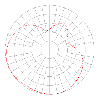
| Antenna Data for Antenna Id: 1008606 KFDM DX File: -0000267267 Dielectric - TFU-8WB/VP-R C160 Service: DX Standard Pattern: Y |  | |||||||||||||||||||||||||||||||||
| Azimuth | Ratio | Azimuth | Ratio | Azimuth | Ratio | Azimuth | Ratio | |||||||||||||||||||||||||||
| 0 | 0.453 | 10 | 0.538 | 20 | 0.619 | 30 | 0.651 | |||||||||||||||||||||||||||
| 40 | 0.619 | 50 | 0.537 | 60 | 0.453 | 67 | 0.430 | |||||||||||||||||||||||||||
| 70 | 0.436 | 80 | 0.510 | 90 | 0.622 | 100 | 0.723 | |||||||||||||||||||||||||||
| 110 | 0.798 | 120 | 0.849 | 130 | 0.889 | 140 | 0.926 | |||||||||||||||||||||||||||
| 150 | 0.961 | 160 | 0.987 | 170 | 0.999 | 173 | 1.000 | |||||||||||||||||||||||||||
| 180 | 0.996 | 190 | 0.983 | 200 | 0.969 | 210 | 0.963 | |||||||||||||||||||||||||||
| 220 | 0.968 | 230 | 0.982 | 240 | 0.995 | 247 | 0.999 | |||||||||||||||||||||||||||
| 250 | 0.999 | 260 | 0.987 | 270 | 0.960 | 280 | 0.926 | |||||||||||||||||||||||||||
| 290 | 0.888 | 300 | 0.847 | 310 | 0.795 | 320 | 0.720 | |||||||||||||||||||||||||||
| 330 | 0.619 | 340 | 0.508 | 350 | 0.435 | 353 | 0.430 | |||||||||||||||||||||||||||
Structure Registration Number 1267265 Structure Type: GTOWER Registered To: San Antonio Television, LLC Structure Address: 2.4 Miles South Off Highway 12 In Vidor, Texas Beaumont, TX County Name: Orange County ASR Issued: 03/12/2020 Date Built: 06/01/2009 Site Elevation: 6.7 m (22 ft.) Structure Height: 243.8 m (800 ft.) Height Overall: 260.6 m (855 ft.) Overall Height AMSL: 267.3 m (877 ft.) FAA Determination: 01/30/2009 FAA Study #: 2009-ASW-215-OE FAA Circular #: 70/7460-1K Paint & Light FAA Chapters: 3, 4, 5, 12 RED LIGHTS/PAINT - REFERENCE ADDITIONAL INFORMATION ON FAA STUDY. PRIOR STUDY 2008-ASW-6977-OE 30-09-20.7 N 93-59-10.6 W (NAD 83) 30-09-19.9 N 93-59-10.0 W (Converted to NAD 27) |
1200 Seventeenth St NW Washington, DC 20036 Phone: 202-663-8195 Limited Liability Company | Title: Cfo Date: 02/28/2025 Application Certifier KFDM Licensee, LLC 1200 Seventeenth St NW Washington, DC 20036 Applicant Paul A Cicelski Lerman Senter PLLC 2001 L Street, NW Suite 400 Washington, DC 20036 Legal Counsel Carl E Gluck Carl T Jones Corp 7901 Yarnwood Court Springfield, VA 22153 Technical Consultant | ||||||||||||||||||||||||||||||||
|
| |||||||||||||||||||||||||||||||||