Accept
By using FCCInfo you agree to the terms & conditions. Read disclaimer Read privacy statement
FCCInfo.com

A Service of Cavell, Mertz & Associates, Inc.
(855) FCC-INFO

KFYR-TV
Call Sign History
KFYR-TV from 04/15/1980
KFYR from ???
Channel 31DT
Virtual Channel 5

Bismarck, ND
License
CP
Application
Allocation
STA


KFYR-TV Service: DT - Digital TV
Channel: 31 Zone: 2
Bismarck, North Dakota
Nielsen DMA™:  Minot - Bsmrck - DCknsn(Wlstn)
Network: NBC
Virtual Channel: 5
DTV TSID: 1881
Facility ID: 41427
FRN: 0018223693

Status: LIC
Application Accepted: 11/08/2007
License Expires: 04/01/2030
File Number: BLCDT-20071108ADF
Prefix Type: This is a License for a commercial digital TV station

FCC Website Links:
  LMS Facility Details
  This Application
  Other KFYR-TV Applications
  Including Superseded Applications
  Service Contour - Open Street Map or USGS Map (41 dBu)
  Service Contour - KML / Google Earth (41 dBu)
  Public Inspection Files
  Rabbit Ears Info Search for KFYR-TV

Site Location: 46-36-20.3 N 100-48-26.4 W (NAD 83)
Site Location: 46-36-20.3 N 100-48-24.9 W (Converted to NAD 27)

ERP: 500 kW
Polarization: Horizontally polarized
HAAT: 389 m (1276 ft.)
Electrical Beam Tilt: 1 degree
R/C AGL: 272 m (892 ft.)
R/C AMSL: 964 m (3163 ft.)

Site Elevation: 692 m. (2270 ft.)
Height Overall*: 336 m (1102 ft.)
(* As Filed In This Application, may differ from ASR Data, Below.)
Directional Antenna - Antenna Make/Model: DIELECTRIC TFU-24DSB-M
Antenna ID: 73210
Polarization: Horizontally polarized

Antenna Data for Antenna Id: 73210
KFYR-TV DT File: BLCDT-20071108ADF
DIELECTRIC - TFU-24DSB-M
Service: DT
Standard Pattern: Y
AzimuthRatioAzimuthRatioAzimuthRatioAzimuthRatio
00.895100.908200.921300.942
400.974500.995600.985700.940
800.865900.7751000.6841100.593
1200.4971300.3921400.2801500.197
1600.1841700.2261800.2571900.227
2000.1832100.1942200.2782300.393
2400.5022500.5992600.6882700.778
2800.8732900.9513000.9933071.000
3100.9983200.9763300.9443400.918
3500.901
Structure Information

Structure Registration Number 1046933

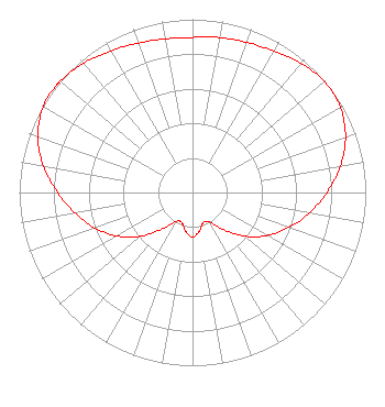
[ASR Heights Differ from KFYR-TV Application]
Structure Type: TOWER
Registered To:
Gray Local Media, Inc.
Structure Address:
5 Miles East Of St. Anthony
St. Anthony, ND
County Name: Morton County
ASR Issued: 08/26/2024
Date Built: 01/01/1998
Site Elevation: 698.6 m (2292 ft.)
Structure Height: 283.2 m (929 ft.)
Height Overall: 335.6 m (1101 ft.)
Overall Height AMSL: 1034.2 m (3393 ft.)
FAA Determination: 06/05/2012
FAA Study #: 2012-AGL-4183-OE
Paint & Light FAA Chapters: 1, 3, 8, 17, 21
Continue As Is OM&L = PAINT/RED LIGHTS
46-36-20.3 N 100-48-26.4 W (NAD 83)
46-36-20.3 N 100-48-24.9 W
(Converted to NAD 27)
KFYR-TV Licensee Information

Gray Television Licensee, LLC
4370 Peachtree Rd NE
Atlanta, GA 30319
Phone: 404-504-9828
Limited Liability Company
20071108ADF Applicant Information

Eric Van Den Branden
Date: 11/08/2007
Application Certifier
Hoak Media of Dakota License, LLC
500 Crescent Court
Suite 220
Dallas, TX 75201
Applicant
Brian Funk
Kfyr-TV
200 N 4th St
Bismarck, ND 58501
Chief Engineer
Tom W. Davidson, Esq.
Akin Gump Strauss Hauer & Feld LLP
1333 New Hampshire Ave., N.W.
Washington, DC 20036

Associated Land Mobile Licenses


 KPE723 Broadcast Auxiliary Remote Pickup
Associated Microwave Licenses


 KB55858 TV Pickup
 KAL34 7 GHz TV Studio Transmitter Link
 KNM90 7 GHz TV Studio Transmitter Link

Study Date: 4/01/2025; Study Duration: 0.0687 Seconds.
Database Sources:
04/01/2025 FCC LMS,
4/1/2025 FCC ASR,
4/1/2025 FCC ULS Microwave, and
4/1/2025 FCC ULS Broadcast Land Mobile.


© 2025 Capitol Airspace Group, LLC.
Alexandria, Virginia


If you have questions or concerns about the station above please contact the station Licensee.
Comments and questions about FCCInfo can be emailed to: webmaster@fccinfo.com