|
WDNJ Channel: 201A 88.1 MHz
Hopatcong, New Jersey
Service: FM - A full-service FM station or application.
Facility ID: 121770
FRN: 0003756665
Fac. Service: FM
Status: LIC
Application Accepted: 02/05/2009
Application Granted: 02/13/2009
File Number: BLED-20090205AAO
License Expires: 06/01/2030
Prefix Type: This is a license for a noncommercial educational FM station
Application Type: License To Cover
FCC Website Links:
LMS Facility Details
This Application
Other WDNJ Applications
Including Superseded Applications
Service Contour - Open Street Map or USGS Map (60 dBu)
Service Contour - KML / Google Earth (60 dBu)
Public Inspection Files
Facility Type: NON-COMMERCIAL EDUC. FM
Class: A, A Zone I; I-A; or II station; with 0.1kW-6kW ERP and a class contour distance <=28km
Site Location: 40-56-25.4 N 74-36-46.6 W (NAD 83)
Site Location: 40-56-25.0 N 74-36-48.0 W (Converted to NAD 27)
Effective Radiated Power: 0 kW Horiz. ; 0.5 kW Vert.
Transmitter Output Power: 0.194 kW
Antenna Center HAAT: 0 m Horiz.; 118 m Vert.
Antenna Center AMSL: 0 m Horiz.; 384 m Vert.
Antenna Center HAG: 0 m Horiz.; 54 m Vert.
Site Elevation: 330 m. (1083 ft.)
Height Overall*: 65 m (213 ft.)
(* As Filed In This Application, may differ from ASR Data, Below.)
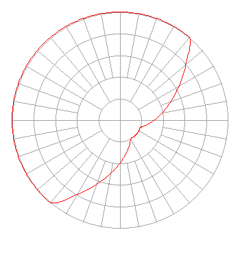
Directional Antenna
Antenna Make/Model: Systems With Reliability Inc. FMEV/2-DA, two sections
Antenna ID: 70519
Polarization:
|
Structure Information
Structure Registration Number 1057470
[ASR Heights Differ from WDNJ Application]
Structure Type: LTOWER
Registered To:
SBA Structures, LLC
Structure Address:
56 Martins View Road (nj20003-a)
Lake Hopatcong, NJ
County Name: Morris County
ASR Issued: 05/25/2023
Date Built: 01/01/1990
Site Elevation: 330.7 m (1085 ft.)
Structure Height: 61.9 m (203 ft.)
Height Overall: 66.1 m (217 ft.)
Overall Height AMSL: 396.8 m (1302 ft.)
FAA Determination: 12/07/2022
FAA Study #: 2022-AEA-181-OE
FAA Circular #: 70/7460-1K
Paint & Light FAA Chapters: 4, 8, 12
OM&L to remain the same as prior study = A MED-DUAL SYSTEM
40-56-25.0 N 74-36-46.7 W (NAD 83)
40-56-24.6 N 74-36-48.1 W
(Converted to NAD 27)
|
WDNJ(FM) Licensee Information
Youngshine Media, Inc.
99 Clinton Road
West Caldwell, NJ 07006
Phone: 973-852-0300
Corporation | 20090205AAO Applicant Information
Ryoung L. Joo
Date: 02/05/2009
Application Certifier
Youngshine Media, Inc.
99 Clinton Road
West Caldwell, NJ 07006
Applicant
Louis R Dutreil Jr
Dutreil Lundin & Rackley Inc
201 Fletcher Ave
Sarasota, FL 34237-6019
Consulting Engineer
Mark B. Denbo, Esq.
Fleischman and Harding LLP
|