|
WPEG Channel: 250C 97.9 MHz
Concord, North Carolina
Service: FM - A full-service FM station or application.
Facility ID: 6586
FRN: 0004077426
Fac. Service: FM Analog & Digital
Status: LIC
Application Accepted: 10/24/2012
Application Granted: 09/23/2014
File Number: BMLH-20121024AAF
License Expires: 12/01/2027
Prefix Type: This is a modification of a license for a commecial FM station
Application Type: Minor Modification
FCC Website Links:
LMS Facility Details
This Application
Other WPEG Applications
Including Superseded Applications
Service Contour - Open Street Map or USGS Map (60 dBu)
Service Contour - KML / Google Earth (60 dBu)
Public Inspection Files
Facility Type: FM STATION
Class: C, A Zone II station; with exactly 100kW ERP and a class contour distance 72km-92km
Site Location: 35-21-44.5 N 81-09-18.3 W (NAD 83)
Site Location: 35-21-44.0 N 81-09-19.0 W (Converted to NAD 27)
Effective Radiated Power: 95 kW Horiz. ; 71.7 kW Vert.
Transmitter Output Power: 29.2 kW
Antenna Center HAAT: 491 m (1611 ft.)
Antenna Center AMSL: 727 m (2385 ft.)
Antenna Center HAG: 483 m (1585 ft.)
Site Elevation: 245.6 m. (806 ft.)
Height Overall*: 592.4 m (1944 ft.)
(* As Filed In This Application, may differ from ASR Data, Below.)
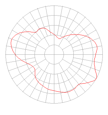
Directional Antenna
Antenna Make/Model: Electronics Research Inc. 1014-4CP-DA, 4 sections, 0.5 wavelength spaced
Antenna ID: 14265
Polarization:
|
Structure Information
Structure Registration Number 1006705
Structure Type: TOWER
Registered To:
Tribune Media Company
Structure Address:
945 Old Willis School Rd
Dallas, NC
County Name: Gaston County
ASR Issued: 11/05/2020
Date Built: 01/01/1986
Site Elevation: 245.6 m (806 ft.)
Structure Height: 575.3 m (1887 ft.)
Height Overall: 592.4 m (1944 ft.)
Overall Height AMSL: 838 m (2749 ft.)
FAA Determination: 10/01/1999
FAA Study #: 99-ASO-4658-OE
Paint & Light FAA Chapters: A1, B, G, H
OM&L CONTINUE 24-HR HI-STROBES. PRIOR FAA 86-ASO-0129-OE
35-21-44.5 N 81-09-18.3 W (NAD 83)
35-21-44.0 N 81-09-19.0 W
(Converted to NAD 27)
|
WPEG(FM) Licensee Information
Beasley Media Group Licenses, LLC
3033 Riviera Drive
Suite 200
Naples, FL 34103
Phone: 239-263-5000
| 20121024AAF Applicant Information
Jo Ann Haller
Date: 10/24/2012
Application Certifier
CBS Radio Holdings, Inc.
Suite 920
1800 K Street NW
Washington, DC 20006
Applicant
Edwin L. Nass
1800 K Street NW, Suite 920
Washington, DC 20006
Director of Spectrum Management
Raymond Benedict
CBS
|