FCCInfo.com
A Service of Cavell, Mertz & Associates, Inc.
(855) FCC-INFO
|
|
KTTU from 06/12/2009 KTTU-TV from 04/01/1989 KDTU from 10/18/1983 801121KE from ??? |
Virtual Channel 18 |  |
|
|||||||||||||||||
|
|
Status: LIC Application Accepted: 09/26/2003 License Expires: 10/01/2030 File Number: BLCDT-20030926ANZ Prefix Type: This is a License for a commercial digital TV station FCC Website Links: LMS Facility Details This Application Other KTTU-TV Applications Including Superseded Applications Service Contour - Open Street Map or USGS Map (41 dBu) Service Contour - KML / Google Earth (41 dBu) Public Inspection Files Rabbit Ears Info Search for KTTU-TV Site Location: 32-24-56.0 N 110-42-52.0 W (NAD 83) Site Location: 32-24-55.7 N 110-42-49.7 W (Converted to NAD 27) ERP: 480 kW Polarization: Horizontally polarized HAAT: 1123 m (3684 ft.) Electrical Beam Tilt: 1.2 degrees R/C AGL: 53 m (174 ft.) R/C AMSL: 2659 m (8724 ft.) Site Elevation: 2606 m. (8550 ft.) Height Overall*: 61.5 m (202 ft.) (* As Filed In This Application, may differ from ASR Data, Below.) Directional Antenna - Antenna Make/Model: DIELECTRIC TUA-C3-12/36H-1-R Antenna ID: 59934 Polarization: Horizontally polarized | ||||||||||||||||||||
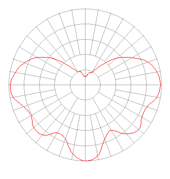
| Antenna Data for Antenna Id: 59934 KTTU-TV DT File: BLCDT-20030926ANZ DIELECTRIC - TUA-C3-12/36H-1-R Service: DT Standard Pattern: Y |  | ||||||||||||||||||||
| Azimuth | Ratio | Azimuth | Ratio | Azimuth | Ratio | Azimuth | Ratio | ||||||||||||||
| 0 | 0.105 | 10 | 0.119 | 20 | 0.166 | 30 | 0.189 | ||||||||||||||
| 40 | 0.329 | 50 | 0.540 | 60 | 0.710 | 70 | 0.871 | ||||||||||||||
| 80 | 0.954 | 90 | 0.985 | 100 | 0.953 | 110 | 0.861 | ||||||||||||||
| 120 | 0.859 | 130 | 0.917 | 140 | 0.843 | 150 | 0.691 | ||||||||||||||
| 160 | 0.757 | 170 | 0.947 | 180 | 1.000 | 190 | 0.920 | ||||||||||||||
| 200 | 0.756 | 210 | 0.733 | 220 | 0.860 | 230 | 0.876 | ||||||||||||||
| 240 | 0.813 | 250 | 0.851 | 260 | 0.953 | 270 | 0.976 | ||||||||||||||
| 280 | 0.925 | 290 | 0.841 | 300 | 0.714 | 310 | 0.530 | ||||||||||||||
| 320 | 0.313 | 330 | 0.198 | 340 | 0.183 | 350 | 0.125 | ||||||||||||||
Structure Registration Number 1007178 Structure Type: Registered To: Gray Local Media, Inc. Structure Address: Top Of Mount Bigelow 18 Mi Ne Tucson, AZ County Name: Pima County ASR Issued: 08/26/2024 Date Built: 09/01/1961 Site Elevation: 2606 m (8550 ft.) Structure Height: 45.7 m (150 ft.) Height Overall: 61.5 m (202 ft.) Overall Height AMSL: 2667.5 m (8752 ft.) Paint & Light FAA Chapters: 1, 3, 11, 21 32-24-56.0 N 110-42-52.0 W (NAD 83) 32-24-55.7 N 110-42-49.7 W (Converted to NAD 27) |
Tegna Inc. 8350 Broad Street, Suite 2000 Tysons, VA 22102 Phone: 703-873-6606 Corporation | Date: 09/26/2003 Application Certifier KTTU-TV, Inc. 400 South Record Street Dallas, TX 75202 Applicant Roy Mitchell 1855 N. 6th Avenue Tucson, AZ 85705 Director of Engineering John M. Burgett Wiley Rein & Fielding LLP 1776 K Street, NW Washington, DC 20006 | |||||||||||||||||||
|
| ||||||||||||||||||||