FCCInfo.com
A Service of Cavell, Mertz & Associates, Inc.
(855) FCC-INFO
|
|
|
Virtual Channel 13 |
|
||||||||||||||||||
|
|
Status: LIC Application Accepted: 01/27/2009 License Expires: 02/01/2031 File Number: BLCDT-20090127AAD Prefix Type: This is a License for a commercial digital TV station FCC Website Links: LMS Facility Details This Application Other KHVO Applications Including Superseded Applications Service Contour - Open Street Map or USGS Map (36 dBu) Service Contour - KML / Google Earth (36 dBu) Public Inspection Files Rabbit Ears Info Search for KHVO Site Location: 19-42-49.0 N 155-08-03.0 W (NAD 83) Site Location: 19-42-59.9 N 155-08-13.0 W (Converted to NAD 27) ERP: 2 kW Polarization: Horizontally polarized HAAT: -92 m R/C AGL: 73 m (240 ft.) R/C AMSL: 336 m (1102 ft.) Site Elevation: 263 m. (863 ft.) Height Overall*: 80 m (262 ft.) (* As Filed In This Application, may differ from ASR Data, Below.) Directional Antenna - Antenna Make/Model: DIELECTRIC THA-C2-2H/4H-1-H Antenna ID: 87327 Polarization: Horizontally polarized | ||||||||||||||||||||
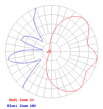
| Antenna Data for Antenna Id: 87327 KHVO DT File: BLCDT-20090127AAD DIELECTRIC - THA-C2-2H/4H-1-H Service: DT Standard Pattern: Y |  | ||||||||||||||||||||
| Azimuth | Ratio | Azimuth | Ratio | Azimuth | Ratio | Azimuth | Ratio | ||||||||||||||
| 0 | 0.306 | 10 | 0.505 | 20 | 0.706 | 30 | 0.863 | ||||||||||||||
| 40 | 0.967 | 46 | 0.996 | 50 | 0.994 | 60 | 0.928 | ||||||||||||||
| 70 | 0.833 | 80 | 0.802 | 90 | 0.925 | 100 | 0.997 | ||||||||||||||
| 110 | 0.921 | 120 | 0.867 | 130 | 0.925 | 140 | 0.995 | ||||||||||||||
| 145 | 1.000 | 150 | 0.979 | 160 | 0.907 | 170 | 0.801 | ||||||||||||||
| 180 | 0.671 | 190 | 0.512 | 200 | 0.324 | 210 | 0.163 | ||||||||||||||
| 220 | 0.091 | 230 | 0.032 | 240 | 0.044 | 250 | 0.072 | ||||||||||||||
| 260 | 0.094 | 270 | 0.072 | 280 | 0.020 | 290 | 0.066 | ||||||||||||||
| 295 | 0.068 | 300 | 0.066 | 310 | 0.045 | 320 | 0.030 | ||||||||||||||
| 330 | 0.075 | 340 | 0.103 | 350 | 0.180 | ||||||||||||||||
Structure Registration Number 1029536 Structure Type: TOWER Registered To: Nexstar Media Inc. Structure Address: 2.1 Km Nw Of Intersection Waianuenue & Akola Piihonua, HI County Name: Hawaii County ASR Issued: 05/28/2021 Date Built: 01/01/1967 Site Elevation: 262.7 m (862 ft.) Structure Height: 78.6 m (258 ft.) Height Overall: 79.6 m (261 ft.) Overall Height AMSL: 342.3 m (1123 ft.) Paint & Light FAA Chapters: 1, 3, 11, 21 19-42-49.0 N 155-08-03.0 W (NAD 83) 19-42-59.9 N 155-08-13.0 W (Converted to NAD 27) |
300 Interstate N. Parkway Suite 300 Atlanta, GA 30339 Phone: 203-216-0357 Corporation | Date: 01/27/2009 Application Certifier Hearst-Argyle Stations, Inc. C/O Brooks, Pierce, Et AL. P.O. Box 1800 Raleigh, NC 27602 Applicant Joseph M. Davis, P.E. Chesapeake RF Consultants, LLC 11993 Kahns Road Manassas, VA 20112 Consulting Engineer Mark J. Prak Brooks, Pierce, Et Al. | |||||||||||||||||||