|
KDXE Channel: 266A 101.1 MHz
Cammack Village, Arkansas
Service: FM - A full-service FM station or application.
Facility ID: 49255
FRN: 0003760352
Fac. Service: FM
Status: LIC
73.215 Station
Application Accepted: 03/08/2010
Application Granted: 03/10/2010
File Number: BLH-20100308ABI
License Expires: 06/01/2028
Prefix Type: This is a license for a commercial FM station
Application Type: License To Cover
FCC Website Links:
LMS Facility Details
This Application
Other KDXE Applications
Including Superseded Applications
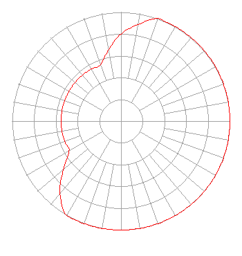
Service Contour - Open Street Map or USGS Map (60 dBu)
Service Contour - KML / Google Earth (60 dBu)
Public Inspection Files
Facility Type: FM STATION
Class: A, A Zone I; I-A; or II station; with 0.1kW-6kW ERP and a class contour distance <=28km
Site Location: 34-47-56.3 N 92-29-44.6 W (NAD 83)
Site Location: 34-47-56.0 N 92-29-44.0 W (Converted to NAD 27)
Effective Radiated Power: 0.85 kW
Transmitter Output Power: 0.7 kW
Antenna Center HAAT: 267 m (876 ft.)
Antenna Center AMSL: 394 m (1293 ft.)
Antenna Center HAG: 73 m (240 ft.)
Calculated Site Elevation: 321 m. (1053 ft.)
Height Overall*: 308 m (1010 ft.)
(* As Filed In This Application, may differ from ASR Data, Below.)
Directional Antenna
Antenna Make/Model: Shivley 6810-2R-SS-DA
Antenna ID: 97613
Polarization:
| Associated Translators |
| K288EZ(FX) |
Ch. 288 | Little Rock, Arkansas |
|
Structure Information
Structure Registration Number 1012584
Structure Type: TOWER
Registered To:
VB-S1 Assets, LLC
Structure Address:
20324 Two Towers Rd
Little Rock, AR
County Name: Pulaski County
ASR Issued: 09/29/2025
Date Built: 02/08/1988
Site Elevation: 320.9 m (1053 ft.)
Structure Height: 308.4 m (1012 ft.)
Height Overall: 308.4 m (1012 ft.)
Overall Height AMSL: 629.3 m (2065 ft.)
FAA Determination: 08/10/1987
FAA Study #: 87-ASW-0374-OE
FAA Circular #: 70/7460-1G
Paint & Light FAA Chapters: 4, 6, 9
34-47-56.0 N 92-29-45.0 W (NAD 83)
34-47-55.7 N 92-29-44.4 W
(Converted to NAD 27)
|
KDXE(FM) Licensee Information
Salem Communications Holding Corporation
770 Paseo Camarillo
Suite 325
Camarillo, CA 93010
Phone: 805-987-0400
| 20100308ABI Applicant Information
George S. Flinn, Jr.
Date: 03/08/2010
Application Certifier
Flinn Broadcasting Corporation
188 South Bellevue
Suite 222
Memphis, TN 38104
Applicant
Charles A. Cooper
Du Treil, Lundin & Rackley, Inc.
201 Fletcher Avenue
Sarasto, FL 34237
Technical Consultant
Stephen C. Simpson
Attorney at Law
|