FCCInfo.com
A Service of Cavell, Mertz & Associates, Inc.
(855) FCC-INFO
|
|
WMAK-FM from 05/26/2004 WMAK from 12/01/2000 WRMX from 02/29/1988 WTMG from 09/19/1985 WZKS from 02/13/1984 |
|  |
|
||||||||||||||||||||||||
|
|
WCJK Channel: 242C1 96.3 MHz Murfreesboro, Tennessee Service: FM - A full-service FM station or application. Facility ID: 61053 FRN: 0002711737 Fac. Service: FM Status: LIC Application Accepted: 05/14/2002 Application Granted: 05/28/2002 File Number: BLH-20020514AAN License Expires: 08/01/2028 Prefix Type: This is a license for a commercial FM station Application Type: License To Cover FCC Website Links: LMS Facility Details This Application Other WCJK Applications Including Superseded Applications Service Contour - Open Street Map or USGS Map (60 dBu) Service Contour - KML / Google Earth (60 dBu) Public Inspection Files Facility Type: FM STATION Class: C1, A Zone II station; with 50kW-100kW ERP and a class contour distance 52km-72km Site Location: 36-15-50.2 N 86-47-39.0 W (NAD 83) Site Location: 36-15-50.0 N 86-47-39.0 W (Converted to NAD 27) Effective Radiated Power: 39 kW Transmitter Output Power: 12.8 kW Antenna Center HAAT: 432 m (1417 ft.) Antenna Center AMSL: 615 m (2018 ft.) Antenna Center HAG: 372 m (1220 ft.) Site Elevation: 243 m. (797 ft.) Height Overall*: 381 m (1250 ft.) (* As Filed In This Application, may differ from ASR Data, Below.) Directional Antenna Antenna Make/Model: Electronics Research Inc. MP-8AC-DA-HW Antenna ID: 39892 Polarization: | |||||||||||||||||||||||||||
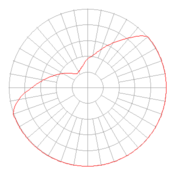
| Antenna Data for Antenna Id: 39892 WCJK FM File: BLH-20020514AAN Electronics Research Inc. - MP-8AC-DA-HW Service: FM |  | |||||||||||||||||||||||||||
| Azimuth | Ratio | Azimuth | Ratio | Azimuth | Ratio | Azimuth | Ratio | |||||||||||||||||||||
| 0 | 0.366 | 10 | 0.413 | 20 | 0.520 | 30 | 0.654 | |||||||||||||||||||||
| 40 | 0.823 | 50 | 1.000 | 60 | 1.000 | 70 | 1.000 | |||||||||||||||||||||
| 80 | 1.000 | 90 | 1.000 | 100 | 1.000 | 110 | 1.000 | |||||||||||||||||||||
| 120 | 1.000 | 130 | 1.000 | 140 | 1.000 | 150 | 1.000 | |||||||||||||||||||||
| 160 | 1.000 | 170 | 1.000 | 180 | 1.000 | 190 | 1.000 | |||||||||||||||||||||
| 200 | 1.000 | 210 | 1.000 | 220 | 1.000 | 230 | 1.000 | |||||||||||||||||||||
| 240 | 1.000 | 250 | 1.000 | 260 | 0.889 | 270 | 0.706 | |||||||||||||||||||||
| 280 | 0.561 | 290 | 0.446 | 300 | 0.355 | 310 | 0.282 | |||||||||||||||||||||
| 320 | 0.225 | 330 | 0.228 | 340 | 0.252 | 350 | 0.295 | |||||||||||||||||||||
Structure Registration Number 1224078 Structure Type: GTOWER Registered To: American Towers LLC Structure Address: 3820 Trail Hollow Lane (023664 / Nashville North) Whites Creek-37189, TN County Name: Davidson County ASR Issued: 06/24/2016 Date Built: 04/06/2009 Site Elevation: 243.2 m (798 ft.) Structure Height: 381.3 m (1251 ft.) Height Overall: 381.3 m (1251 ft.) Overall Height AMSL: 624.5 m (2049 ft.) FAA Determination: 12/13/2013 FAA Study #: 2013-ASO-10891-OE FAA Circular #: 70/7460-1K Paint & Light FAA Chapters: 4, 7, 12 OM&L to remain the same as prior study = 24-HR HI-STROBES 36-15-49.8 N 86-47-38.9 W (NAD 83) 36-15-49.6 N 86-47-38.9 W (Converted to NAD 27) |
904 Grand Ave. Wausau, WI 54403 Phone: 000-000-0000 Corporation | Date: 05/14/2002 Application Certifier South Central Communications Corporation P.O. Box 3848 Evansville, IN 47736 Applicant Neil M. Smith 2237 Tackett's Mill Drive Suite A Lake Ridge, VA 22191 Broadcast Consultant Edward S. O'Neill Fletcher, Heald & Hildreth, P.L.C. | ||||||||||||||||||||||||||
|
| |||||||||||||||||||||||||||