
FCCInfo.com
A Service of Cavell, Mertz & Associates, Inc.
(855) FCC-INFO
|
|
W281BO from 04/29/2014 W281BO from 08/09/2013 W281BO from 04/19/2004 |
|
|
||||||||||||||||
|
|
W281BO Channel: 281D 104.1 MHz Taylorville, Illinois Service: FX - A translator or application for a translator. Facility ID: 148859 Fac. Service: FX Programming Delivery Method: Unspecified Status: LIC Application Accepted: 09/24/2014 Application Granted: 10/23/2014 File Number: BLFT-20140924AGC Prefix Type: This is a license for a translator Application Type: License To Cover FCC Website Links: LMS Facility Details This Application CDBS Application Other W281BO Applications Other W281BO Applications in CDBS Including Superseded Applications Mailing Address Correspondence for W281BO Correspondence related to application BLFT-20140924AGC Service Contour - Open Street Map or USGS Map (60 dBu) Service Contour - KML / Google Earth (60 dBu) Class: D, A Noncommercial educational operating with no more than 10W Site Location: 39-27-08.2 N 89-17-10.3 W (NAD 83) Site Location: 39-27-08.0 N 89-17-10.0 W (Converted to NAD 27) Effective Radiated Power: 0.22 kW Transmitter Output Power: 0.37 kW Antenna Center HAAT: 0 m Antenna Center AMSL: 285 m (935 ft.) Antenna Center HAG: 80 m (262 ft.) Site Elevation: 205 m. (673 ft.) Height Overall*: 105 m (344 ft.) (* As Filed In This Application, may differ from ASR Data, Below.) Directional Antenna Antenna Make/Model: None Antenna ID: 118493 Polarization:
| ||||||||||||||||||
| Antenna Data for Antenna Id: 118493 W281BO FX File: BLFT-20140924AGC None - Service: FX | 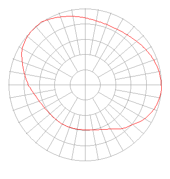 | ||||||||||||||||||
| Azimuth | Ratio | Azimuth | Ratio | Azimuth | Ratio | Azimuth | Ratio | ||||||||||||
| 0 | 0.877 | 10 | 0.851 | 20 | 0.839 | 30 | 0.839 | ||||||||||||
| 40 | 0.856 | 50 | 0.884 | 60 | 0.918 | 70 | 0.953 | ||||||||||||
| 80 | 0.982 | 90 | 0.996 | 95 | 1.000 | 100 | 0.989 | ||||||||||||
| 110 | 0.956 | 120 | 0.899 | 130 | 0.816 | 140 | 0.753 | ||||||||||||
| 150 | 0.673 | 160 | 0.627 | 170 | 0.603 | 180 | 0.593 | ||||||||||||
| 190 | 0.592 | 200 | 0.594 | 210 | 0.595 | 220 | 0.595 | ||||||||||||
| 230 | 0.598 | 240 | 0.611 | 250 | 0.636 | 260 | 0.678 | ||||||||||||
| 270 | 0.743 | 280 | 0.802 | 290 | 0.873 | 300 | 0.946 | ||||||||||||
| 310 | 0.982 | 320 | 0.995 | 325 | 1.000 | 330 | 0.980 | ||||||||||||
| 340 | 0.945 | 350 | 0.910 | ||||||||||||||||
Structure Registration Number 1219448 Structure Type: TOWER Registered To: Miller Communications Inc Structure Address: Appx 5 1/2 Miles Southeast Of Clarksdale Il Clarksdale, IL County Name: Christian County ASR Issued: 11/08/2000 Date Built: 11/26/2001 Site Elevation: 205 m (673 ft.) Structure Height: 104 m (341 ft.) Height Overall: 105 m (344 ft.) Overall Height AMSL: 310 m (1017 ft.) FAA Determination: 10/18/2000 FAA Study #: 00-AGL-6444-OE FAA Circular #: 70/7460-1K Paint & Light FAA Chapters: 4, 6, 12 39-27-08.2 N 89-17-10.3 W (NAD 83) 39-27-08.0 N 89-17-10.0 W (Converted to NAD 27) |
P.o. Box 169 Taylorville, IL 62568 Phone: 217-824-3395 | Date: 09/24/2014 Application Certifier MILLER COMMUNICATIONS, INC. P.o. Box 169 Taylorvillle, IL 62568-0169 Applicant JIM TURVAVILLE Turbo Technical Services 4825-104 Garden Ranch Drive Colorado Springs, CO 80918 CONSULTING ENGINEER JOHN GARZIGLIA. Womble Carlyle Sandridge & Rice, Pllc 1401 I Street, N.w. Suite 700 Washington, DC 20005 | |||||||||||||||||