FCCInfo.com
A Service of Cavell, Mertz & Associates, Inc.
(855) FCC-INFO
|
|
KTUL-TV from 06/21/1979 KTUL from ??? |
Virtual Channel 8 |
|
||||||||||||||||||||||||||||||||||||||||||||||
|
|
Status: LIC Application Accepted: 04/21/2014 License Expires: 06/01/2030 File Number: BLCDT-20140421ADF Prefix Type: This is a License for a commercial digital TV station FCC Website Links: LMS Facility Details This Application Other KTUL Applications Including Superseded Applications Service Contour - Open Street Map or USGS Map (51 dBu) Service Contour - KML / Google Earth (51 dBu) Public Inspection Files Rabbit Ears Info Search for KTUL Site Location: 34-59-13.0 N 95-42-11.0 W (NAD 83) Site Location: 34-59-12.7 N 95-42-10.0 W (Converted to NAD 27) ERP: 0.6 kW R/C AGL: 106.7 m (350 ft.) R/C AMSL: 361.2 m (1185 ft.) Emission Mask: Stringent Site Elevation: 254.5 m. (835 ft.) Height Overall*: 150.2 m (493 ft.) (* As Filed In This Application, may differ from ASR Data, Below.) Directional Antenna - Antenna Make/Model: Kathrein 770 881 Antenna ID: 111780 | ||||||||||||||||||||||||||||||||||||||||||||||||
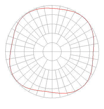
| Antenna Data for Antenna Id: 111780 KTUL LD File: BLCDT-20140421ADF Kathrein - 770 881 Service: LD Standard Pattern: Y |  | ||||||||||||||||||||||||||||||||||||||||||||||||
| Azimuth | Ratio | Azimuth | Ratio | Azimuth | Ratio | Azimuth | Ratio | ||||||||||||||||||||||||||||||||||||||||||
| 0 | 0.931 | 10 | 0.930 | 20 | 0.948 | 30 | 0.976 | ||||||||||||||||||||||||||||||||||||||||||
| 40 | 0.996 | 50 | 0.996 | 60 | 0.975 | 70 | 0.941 | ||||||||||||||||||||||||||||||||||||||||||
| 80 | 0.904 | 90 | 0.882 | 100 | 0.886 | 110 | 0.914 | ||||||||||||||||||||||||||||||||||||||||||
| 120 | 0.956 | 130 | 0.990 | 140 | 1.000 | 150 | 0.985 | ||||||||||||||||||||||||||||||||||||||||||
| 160 | 0.951 | 170 | 0.910 | 180 | 0.880 | 190 | 0.872 | ||||||||||||||||||||||||||||||||||||||||||
| 200 | 0.892 | 210 | 0.929 | 220 | 0.966 | 230 | 0.984 | ||||||||||||||||||||||||||||||||||||||||||
| 240 | 0.979 | 250 | 0.953 | 260 | 0.917 | 270 | 0.886 | ||||||||||||||||||||||||||||||||||||||||||
| 280 | 0.871 | 290 | 0.881 | 300 | 0.912 | 310 | 0.949 | ||||||||||||||||||||||||||||||||||||||||||
| 320 | 0.972 | 330 | 0.977 | 340 | 0.966 | 350 | 0.947 | ||||||||||||||||||||||||||||||||||||||||||
Structure Registration Number 1051571 Structure Type: TOWER Registered To: LITTLE DIXIE RADIO INC DBA = KMCO FM Structure Address: 2 Mile Lane Krebs, OK County Name: Pittsburg County ASR Issued: 06/30/1998 Site Elevation: 254.5 m (835 ft.) Structure Height: 150.2 m (493 ft.) Height Overall: 150.2 m (493 ft.) Overall Height AMSL: 404.7 m (1328 ft.) FAA Determination: 09/27/1996 FAA Study #: 96-ASW-2259-OE FAA Circular #: 70/7460-1J Paint & Light FAA Chapters: 3, 4, 5, 13 34-59-13.0 N 95-42-11.0 W (NAD 83) 34-59-12.7 N 95-42-10.0 W (Converted to NAD 27) |
Pillsbury Winthrop Shaw Pittman LLP 1200 Seventeenth Street, NW Washington, MD 20036 Phone: 202-663-8195 Limited Liability Company | Date: 04/21/2014 Application Certifier KTUL, LLC 3333 S. 29th West Avenue Tulsa, OK 74107 Applicant Daniel G. Ryson Cavell, Mertz & Associates, Inc. 7724 Donegan Dr. Manassas, VA 20109-2868 Consultant Jerald N. Fritz Allbritton Communications Company | |||||||||||||||||||||||||||||||||||||||||||||||
|
| ||||||||||||||||||||||||||||||||||||||||||||||||