FCCInfo.com
A Service of Cavell, Mertz & Associates, Inc.
(855) FCC-INFO
|
|
WLFI from ??? |
Virtual Channel 18 |
|
|||||||||||||||||||||||||
|
|
Status: LIC Application Accepted: 05/20/2004 License Expires: 08/01/2029 File Number: BLCDT-20040520AIX Prefix Type: This is a License for a commercial digital TV station FCC Website Links: LMS Facility Details This Application Other WLFI-TV Applications Including Superseded Applications Service Contour - Open Street Map or USGS Map (36 dBu) Service Contour - KML / Google Earth (36 dBu) Public Inspection Files Rabbit Ears Info Search for WLFI-TV Site Location: 40-23-20.0 N 86-36-46.0 W (NAD 83) Site Location: 40-23-19.9 N 86-36-46.0 W (Converted to NAD 27) ERP: 30 kW Polarization: Horizontally polarized HAAT: 214 m (702 ft.) Electrical Beam Tilt: 0.75 degrees R/C AGL: 205 m (673 ft.) R/C AMSL: 440 m (1444 ft.) Site Elevation: 235 m. (771 ft.) Height Overall*: 240 m (787 ft.) (* As Filed In This Application, may differ from ASR Data, Below.) Directional Antenna - Antenna Make/Model: DIELECTRIC TW-7B11-R (S) Antenna ID: 46110 Polarization: Horizontally polarized | |||||||||||||||||||||||||||
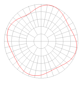
| Antenna Data for Antenna Id: 46110 WLFI-TV DT File: BLCDT-20040520AIX DIELECTRIC - TW-7B11-R (S) Service: DT Standard Pattern: Y |  | |||||||||||||||||||||||||||
| Azimuth | Ratio | Azimuth | Ratio | Azimuth | Ratio | Azimuth | Ratio | |||||||||||||||||||||
| 0 | 0.943 | 10 | 0.989 | 16 | 1.000 | 20 | 0.999 | |||||||||||||||||||||
| 30 | 0.973 | 40 | 0.926 | 50 | 0.882 | 60 | 0.860 | |||||||||||||||||||||
| 70 | 0.871 | 80 | 0.907 | 90 | 0.950 | 100 | 0.978 | |||||||||||||||||||||
| 110 | 0.980 | 120 | 0.953 | 130 | 0.907 | 140 | 0.861 | |||||||||||||||||||||
| 150 | 0.836 | 160 | 0.843 | 170 | 0.875 | 180 | 0.916 | |||||||||||||||||||||
| 190 | 0.945 | 200 | 0.951 | 210 | 0.931 | 220 | 0.894 | |||||||||||||||||||||
| 230 | 0.857 | 240 | 0.837 | 250 | 0.843 | 260 | 0.869 | |||||||||||||||||||||
| 270 | 0.904 | 280 | 0.932 | 290 | 0.942 | 300 | 0.925 | |||||||||||||||||||||
| 310 | 0.883 | 320 | 0.833 | 330 | 0.805 | 340 | 0.821 | |||||||||||||||||||||
| 350 | 0.877 | |||||||||||||||||||||||||||
Structure Registration Number 1025374 Structure Type: TOWER Registered To: Lafayette TV, LLC Structure Address: Int 600w & 700n Rossville, IN County Name: Clinton County ASR Issued: 08/08/2019 Date Built: 04/01/1973 Site Elevation: 234.7 m (770 ft.) Structure Height: 220.7 m (724 ft.) Height Overall: 239.9 m (787 ft.) Overall Height AMSL: 474.6 m (1557 ft.) FAA Determination: 08/02/1971 FAA Study #: 71-GL-354-OE Paint & Light FAA Chapters: 1, 3, 6, 15, 21 RED LIGHTS/PAINT 40-23-20.0 N 86-36-46.0 W (NAD 83) 40-23-19.9 N 86-36-46.0 W (Converted to NAD 27) |
4370 Peachtree Road, NE Atlanta, GA 30319 Phone: 404-504-9828 Limited Liability Company | Date: 05/20/2004 Application Certifier Primeland Television, Inc. C/O Lin Television Corporation 4 Richmond Square Providence, RI 02906 Applicant Terry Van Bibber WISH-TV 1950 N. Meridian Street Indianapolis, IN 46202 Regional Chief Engineer William H. Fitz, Esq. Covington & Burling 1201 Pennsylvania Ave., N.W. Washington, DC 20004-2401 | ||||||||||||||||||||||||||
|
| |||||||||||||||||||||||||||