FCCInfo.com
A Service of Cavell, Mertz & Associates, Inc.
(855) FCC-INFO
|
|
KOCO from ??? |
Virtual Channel 5 |  |
|
||||||||||||||||||||||||||||||||||||||||||
|
|
Status: LIC Application Accepted: 11/08/2012 License Expires: 06/01/2030 File Number: BXLCDT-20121108AAR Prefix Type: This is BXLCDT FCC Website Links: LMS Facility Details This Application Other KOCO-TV Applications Including Superseded Applications Service Contour - Open Street Map or USGS Map (36 dBu) Service Contour - KML / Google Earth (36 dBu) Public Inspection Files Rabbit Ears Info Search for KOCO-TV Site Location: 35-33-45.0 N 97-29-25.0 W (NAD 83) Site Location: 35-33-44.8 N 97-29-23.9 W (Converted to NAD 27) ERP: 101 kW Polarization: Horizontally polarized HAAT: 370 m (1214 ft.) Electrical Beam Tilt: 0.5 degrees R/C AGL: 366 m (1201 ft.) R/C AMSL: 721 m (2365 ft.) Site Elevation: 355 m. (1165 ft.) Height Overall*: 476 m (1562 ft.) (* As Filed In This Application, may differ from ASR Data, Below.) Directional Antenna - Antenna Make/Model: DIELECTRIC THV-6A7-R C170SP Antenna ID: 101349 Polarization: Horizontally polarized | |||||||||||||||||||||||||||||||||||||||||||||
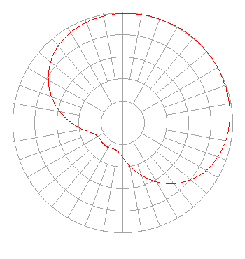
| Antenna Data for Antenna Id: 101349 KOCO-TV DX File: BXLCDT-20121108AAR DIELECTRIC - THV-6A7-R C170SP Service: DX Standard Pattern: Y |  | |||||||||||||||||||||||||||||||||||||||||||||
| Azimuth | Ratio | Azimuth | Ratio | Azimuth | Ratio | Azimuth | Ratio | |||||||||||||||||||||||||||||||||||||||
| 0 | 0.988 | 10 | 0.993 | 20 | 0.997 | 30 | 1.000 | |||||||||||||||||||||||||||||||||||||||
| 37 | 1.000 | 40 | 1.000 | 50 | 0.998 | 60 | 0.995 | |||||||||||||||||||||||||||||||||||||||
| 70 | 0.990 | 80 | 0.983 | 90 | 0.971 | 100 | 0.952 | |||||||||||||||||||||||||||||||||||||||
| 110 | 0.922 | 120 | 0.875 | 130 | 0.809 | 140 | 0.723 | |||||||||||||||||||||||||||||||||||||||
| 150 | 0.621 | 160 | 0.509 | 170 | 0.401 | 180 | 0.312 | |||||||||||||||||||||||||||||||||||||||
| 190 | 0.262 | 200 | 0.252 | 210 | 0.259 | 220 | 0.261 | |||||||||||||||||||||||||||||||||||||||
| 230 | 0.254 | 235 | 0.252 | 240 | 0.254 | 250 | 0.287 | |||||||||||||||||||||||||||||||||||||||
| 260 | 0.362 | 270 | 0.465 | 280 | 0.577 | 290 | 0.684 | |||||||||||||||||||||||||||||||||||||||
| 300 | 0.777 | 310 | 0.851 | 320 | 0.905 | 330 | 0.942 | |||||||||||||||||||||||||||||||||||||||
| 340 | 0.965 | 350 | 0.979 | |||||||||||||||||||||||||||||||||||||||||||
Structure Registration Number 1009951 [ASR Heights Differ from KOCO-TV Application] Structure Type: GTOWER Registered To: Ohio/Oklahoma Hearst Television Inc. Structure Address: 1250 E Britton Rd Oklahoma City, OK County Name: Oklahoma County ASR Issued: 03/06/2017 Date Built: 03/20/2017 Site Elevation: 354.5 m (1163 ft.) Structure Height: 436 m (1430 ft.) Height Overall: 460.8 m (1512 ft.) Overall Height AMSL: 815.3 m (2675 ft.) FAA Determination: 03/02/2017 FAA Study #: 2017-ASW-1797-OE FAA Circular #: 70/7460-1L Paint & Light FAA Chapters: 3, 4, 5, 12 PRIOR STUDY 2009-ASW-5853-OE 35-33-45.0 N 97-29-25.0 W (NAD 83) 35-33-44.8 N 97-29-23.9 W (Converted to NAD 27) |
P.O. Box 1800 Raleigh, NC 27602 Phone: 919-839-0300 Corporation | Date: 11/08/2012 Application Certifier Ohio/Oklahoma Hearst Television Inc. C/O Brooks, Pierce, Et AL. PO Box 1800 Raleigh, NC 27602 Applicant Bernard R. Segal, P. E. 3612 Sandy Court Kensington, MD 20895-1421 Consulting Engineer Mark J. Prak Brooks, Pierce, Et Al. P.O. Box 1800 Raleigh, NC 27602 | ||||||||||||||||||||||||||||||||||||||||||||
|
| |||||||||||||||||||||||||||||||||||||||||||||