FCCInfo.com
A Service of Cavell, Mertz & Associates, Inc.
(855) FCC-INFO
|
|
|
|
|
||||||||||||||||
|
|
Status: LIC Application Accepted: 03/26/2009 License Expires: 10/01/2030 File Number: BLDTL-20090326ADB Prefix Type: This is BLDTL FCC Website Links: LMS Facility Details This Application Other KPHE-LD Applications Including Superseded Applications Service Contour - Open Street Map or USGS Map (51 dBu) Service Contour - KML / Google Earth (51 dBu) Rabbit Ears Info Search for KPHE-LD Site Location: 33-20-01.0 N 112-03-48.0 W (NAD 83) Site Location: 33-20-00.8 N 112-03-45.5 W (Converted to NAD 27) ERP: 15 kW Electrical Beam Tilt: 1.75 degrees R/C AGL: 27.7 m (91 ft.) R/C AMSL: 838.4 m (2751 ft.) Emission Mask: Simple Site Elevation: 810.7 m. (2660 ft.) Height Overall*: 104.5 m (343 ft.) (* As Filed In This Application, may differ from ASR Data, Below.) Directional Antenna - Antenna Make/Model: Electronics Research Inc. AL8W-16-PL Antenna ID: 89368 | ||||||||||||||||||
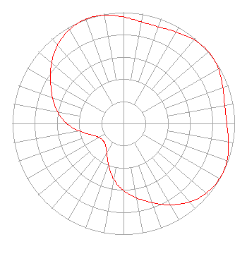
| Antenna Data for Antenna Id: 89368 KPHE-LD LD File: BLDTL-20090326ADB Electronics Research Inc. - AL8W-16-PL Service: LD Standard Pattern: Y Pattern and Field Values Include a 50° Clockwise Rotation |  | ||||||||||||||||||
| Azimuth | Ratio | Azimuth | Ratio | Azimuth | Ratio | Azimuth | Ratio | ||||||||||||
| 0 | 0.959 | 10 | 0.929 | 20 | 0.925 | 30 | 0.951 | ||||||||||||
| 40 | 0.985 | 50 | 1.000 | 60 | 0.985 | 70 | 0.951 | ||||||||||||
| 80 | 0.925 | 90 | 0.929 | 100 | 0.959 | 110 | 0.990 | ||||||||||||
| 120 | 0.997 | 130 | 0.975 | 140 | 0.922 | 150 | 0.845 | ||||||||||||
| 160 | 0.758 | 170 | 0.680 | 180 | 0.605 | 190 | 0.510 | ||||||||||||
| 200 | 0.397 | 210 | 0.302 | 220 | 0.253 | 230 | 0.241 | ||||||||||||
| 240 | 0.253 | 250 | 0.302 | 260 | 0.397 | 270 | 0.510 | ||||||||||||
| 280 | 0.605 | 290 | 0.680 | 300 | 0.758 | 310 | 0.845 | ||||||||||||
| 320 | 0.922 | 330 | 0.975 | 340 | 0.997 | 350 | 0.990 | ||||||||||||
Structure Registration Number 1002070 Structure Type: TOWER Registered To: Gray Local Media, Inc. Structure Address: South Mountain Antenna Farm Approx 8 Mi S Phoenix, AZ County Name: Maricopa County ASR Issued: 08/26/2024 Date Built: 05/01/1986 Site Elevation: 810.7 m (2660 ft.) Structure Height: 74 m (243 ft.) Height Overall: 104.5 m (343 ft.) Overall Height AMSL: 915.2 m (3003 ft.) FAA Determination: 01/30/1986 FAA Study #: 86-AWP-009-OE FAA Circular #: 70/7460-1G Paint & Light FAA Chapters: 3, 4, 5, 9 33-20-01.0 N 112-03-48.0 W (NAD 83) 33-20-00.8 N 112-03-45.5 W (Converted to NAD 27) |
4370 Peachtree Road, NE Atlanta, GA 30319 Phone: 404-504-9828 Limited Liability Company | Date: 03/26/2009 Application Certifier Lotus TV of Phoenix, LLC 3301 Barham Boulevard Suite 200 Los Angeles, CA 90068 Applicant D. Scott Turpie Lohnes and Culver 8309 Cherry Lane Laurel, MD 20707-4830 Technical Consultant Jerome S. Boros Bryan Cave, LLP | |||||||||||||||||
| |||||||||||||||||||