FCCInfo.com
A Service of Cavell, Mertz & Associates, Inc.
(855) FCC-INFO
|
|
960930KP from ??? |
Virtual Channel 21 |
|
||||||||||||||||||||||||
|
|
Status: LIC Application Accepted: 06/19/2009 License Expires: 10/01/2030 File Number: BLCDT-20090619ABH Prefix Type: This is a License for a commercial digital TV station FCC Website Links: LMS Facility Details This Application Other KRWB-TV Applications Including Superseded Applications Service Contour - Open Street Map or USGS Map (41 dBu) Service Contour - KML / Google Earth (41 dBu) Public Inspection Files Rabbit Ears Info Search for KRWB-TV Site Location: 33-06-01.0 N 104-15-18.0 W (NAD 83) Site Location: 33-06-00.6 N 104-15-16.1 W (Converted to NAD 27) ERP: 1000 kW Polarization: Horizontally polarized HAAT: 128 m (420 ft.) Electrical Beam Tilt: 0.5 degrees R/C AGL: 137 m (449 ft.) R/C AMSL: 1188 m (3898 ft.) Site Elevation: 1051 m. (3448 ft.) Height Overall*: 157 m (515 ft.) (* As Filed In This Application, may differ from ASR Data, Below.) Directional Antenna - Antenna Make/Model: DIELECTRIC TFU-29JSC-R 3BP260 Antenna ID: 87546 Polarization: Horizontally polarized
| ||||||||||||||||||||||||||
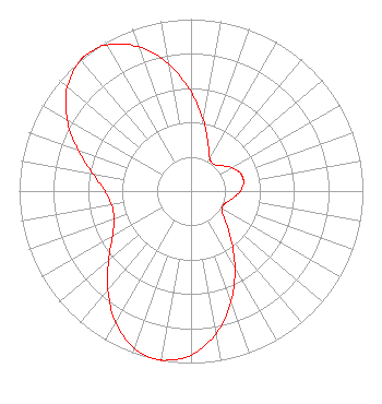
| Antenna Data for Antenna Id: 87546 KRWB-TV DT File: BLCDT-20090619ABH DIELECTRIC - TFU-29JSC-R 3BP260 Service: DT Standard Pattern: Y |  | ||||||||||||||||||||||||||
| Azimuth | Ratio | Azimuth | Ratio | Azimuth | Ratio | Azimuth | Ratio | ||||||||||||||||||||
| 0 | 0.579 | 10 | 0.416 | 20 | 0.291 | 30 | 0.220 | ||||||||||||||||||||
| 40 | 0.204 | 50 | 0.230 | 60 | 0.272 | 70 | 0.305 | ||||||||||||||||||||
| 77 | 0.312 | 80 | 0.311 | 90 | 0.287 | 100 | 0.246 | ||||||||||||||||||||
| 110 | 0.211 | 120 | 0.207 | 130 | 0.256 | 140 | 0.360 | ||||||||||||||||||||
| 150 | 0.511 | 160 | 0.683 | 170 | 0.841 | 180 | 0.954 | ||||||||||||||||||||
| 190 | 0.999 | 191 | 1.000 | 200 | 0.971 | 210 | 0.879 | ||||||||||||||||||||
| 220 | 0.752 | 230 | 0.624 | 240 | 0.527 | 250 | 0.477 | ||||||||||||||||||||
| 257 | 0.467 | 260 | 0.469 | 270 | 0.501 | 280 | 0.580 | ||||||||||||||||||||
| 290 | 0.699 | 300 | 0.831 | 310 | 0.940 | 320 | 0.996 | ||||||||||||||||||||
| 323 | 1.000 | 330 | 0.981 | 340 | 0.893 | 350 | 0.750 | ||||||||||||||||||||
Structure Registration Number 1006048 [ASR Heights Differ from KRWB-TV Application] Structure Type: GTOWER Registered To: American Towers LLC Structure Address: 5.5 Mi East Of Hagerman On Sr 249 (373204) Hagerman, NM County Name: Chaves County ASR Issued: 08/07/2025 Date Built: 02/03/1984 Site Elevation: 1051 m (3448 ft.) Structure Height: 152.4 m (500 ft.) Height Overall: 156.1 m (512 ft.) Overall Height AMSL: 1207.1 m (3960 ft.) FAA Determination: 02/11/2025 FAA Study #: 2025-ASW-561-OE FAA Circular #: 70/7460-1L Paint & Light FAA Chapters: 4, 8, 12 PRIOR STUDY 2015-ASW-6657-OE 33-06-01.2 N 104-15-17.0 W (NAD 83) 33-06-00.8 N 104-15-15.1 W (Converted to NAD 27) |
4822 Kemp Boulevard Suite 300 Wichita Falls, TX 76308 Phone: 940-228-7861 Limited Liability Company | Date: 06/19/2009 Application Certifier Acme Television Licenses of New Mexico, LLC 2101 East Fourth Street Suite 202A Santa Ana, CA 92705-3814 Applicant L. Brent Stephenson Acme Television, LLC L. Brent Stephenson 2101 E. Fourth Street #202A Santa Ana, CA 92705 VP Operations & Engineering | |||||||||||||||||||||||||
| |||||||||||||||||||||||||||