FCCInfo.com
A Service of Cavell, Mertz & Associates, Inc.
(855) FCC-INFO
|
KMEX-TV from 09/08/1980 KMEX from ??? |
Virtual Channel 34 | ![]() |
|
|||||||||||||||||||||||||||
|
Status: LIC (Licensed And Reduced Power) Application Accepted: 12/03/2012 License Expires: 12/01/2022 File Number: BLCDT-20121203ASI Prefix Type: This is a License for a commercial digital TV station FCC Website Links: LMS Facility Details This Application Other KMEX-DT Applications Including Superseded Applications Service Contour - Open Street Map or USGS Map (41 dBu) Service Contour - KML / Google Earth (41 dBu) Public Inspection Files Rabbit Ears Info Search for KMEX-DT Site Location: 34-13-36.1 N 118-04-02.3 W (NAD 83) Site Location: 34-13-36.1 N 118-03-59.1 W (Converted to NAD 27) ERP: 500 kW Polarization: Elliptically polarized HAAT: 956 m (3136 ft.) Electrical Beam Tilt: 1.5 degrees R/C AGL: 98 m (322 ft.) R/C AMSL: 1839 m (6033 ft.) Site Elevation: 1741 m. (5712 ft.) Height Overall*: 106.7 m (350 ft.) (* As Filed In This Application, may differ from ASR Data, Below.) Directional Antenna - Antenna Make/Model: Andrew ATW22HS6-ETC2L-34H Antenna ID: 96279 Polarization: Elliptically polarized | ||||||||||||||||||||||||||||||
Antenna Data for Antenna Id: 96279 KMEX-DT DT File: BLCDT-20121203ASI Andrew - ATW22HS6-ETC2L-34H Service: DT Standard Pattern: Y | |||||||||||||||||||||||||||||||
Azimuth | Ratio | Azimuth | Ratio | Azimuth | Ratio | Azimuth | Ratio | ||||||||||||||||||||||||
0 | 0.305 | 10 | 0.416 | 20 | 0.505 | 30 | 0.455 | ||||||||||||||||||||||||
40 | 0.329 | 50 | 0.316 | 60 | 0.486 | 70 | 0.692 | ||||||||||||||||||||||||
80 | 0.823 | 90 | 0.890 | 100 | 0.912 | 110 | 0.937 | ||||||||||||||||||||||||
120 | 1.000 | 130 | 0.908 | 140 | 0.784 | 150 | 0.637 | ||||||||||||||||||||||||
160 | 0.503 | 170 | 0.406 | 180 | 0.364 | 190 | 0.345 | ||||||||||||||||||||||||
200 | 0.336 | 210 | 0.340 | 220 | 0.358 | 230 | 0.392 | ||||||||||||||||||||||||
240 | 0.458 | 250 | 0.565 | 260 | 0.686 | 270 | 0.784 | ||||||||||||||||||||||||
280 | 0.801 | 290 | 0.795 | 300 | 0.845 | 310 | 0.849 | ||||||||||||||||||||||||
320 | 0.834 | 330 | 0.752 | 340 | 0.565 | 350 | 0.355 | ||||||||||||||||||||||||
Structure Registration Number 1232157 
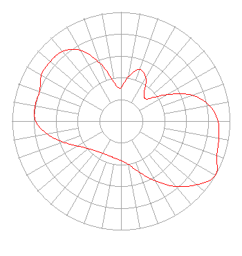
[ASR Heights Differ from KMEX-DT Application] Structure Type: LTOWER Registered To: SBA Towers XI, LLC Structure Address: On Mt. Wilson (ca189a0-a) Pasadena, CA County Name: Los Angeles County ASR Issued: 01/02/2025 Date Built: 08/11/2002 Site Elevation: 1742.2 m (5716 ft.) Structure Height: 106.7 m (350 ft.) Height Overall: 113.7 m (373 ft.) Overall Height AMSL: 1855.9 m (6089 ft.) FAA Determination: 10/24/2024 FAA Study #: 2024-AWP-12704-OE FAA Circular #: 70/7460-1M Paint & Light FAA Chapters: 4, 8, 15 PRIOR STUDY 2001-AWP-2311-OE 34-13-36.1 N 118-04-02.5 W (NAD 83) 34-13-36.1 N 118-03-59.3 W (Converted to NAD 27) |
8551 NW 30th Terrace Miami, FL 33122 Phone: 310-348-3600 General Partnership | Date: 12/03/2012 Application Certifier KMEX License Partnership, G.P. 5999 Center Drive Los Angeles, CA 90045 Applicant Karl D. Lahm, P.E. Univision Management Co. P.O. Box 847 Lake Villa, IL 60046 Director, RF Systems Engineering Mace J. Rosenstein Covington & Burling LLP 1201 Pennsylvania Avenue, NW Washington, DC 20004 | |||||||||||||||||||||||||||||
|
|