FCCInfo.com
A Service of Cavell, Mertz & Associates, Inc.
(855) FCC-INFO
|
|
KIMG-LP from 09/16/2011 DKIMG-LP from 01/24/2011 KIMG-LP from 12/29/2003 K23EQ from 01/09/1997 K08LJ from 01/09/1997 820607TR from ??? |
|
|
||||||||||||||||
|
|
Status: LIC Application Accepted: 05/08/2013 License Expires: 05/16/2025 File Number: BLDTL-20130508ABU Prefix Type: This is BLDTL FCC Website Links: LMS Facility Details This Application Other KIMG-LD Applications Including Superseded Applications Service Contour - Open Street Map or USGS Map (51 dBu) Service Contour - KML / Google Earth (51 dBu) Rabbit Ears Info Search for KIMG-LD Site Location: 34-20-57.0 N 119-20-07.0 W (NAD 83) Site Location: 34-20-57.0 N 119-20-03.6 W (Converted to NAD 27) ERP: 1.5 kW R/C AGL: 15 m (49 ft.) R/C AMSL: 648.9 m (2129 ft.) Emission Mask: Full Service Site Elevation: 633.9 m. (2080 ft.) Height Overall*: 41.1 m (135 ft.) (* As Filed In This Application, may differ from ASR Data, Below.) Directional Antenna - Antenna Make/Model: Scala 4DR-4-2HW Antenna ID: 20741 | ||||||||||||||||||
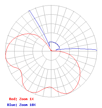
| Antenna Data for Antenna Id: 20741 KIMG-LD LD File: BLDTL-20130508ABU Scala - 4DR-4-2HW Service: LD Standard Pattern: Y Pattern and Field Values Include a 210° Clockwise Rotation |  | ||||||||||||||||||
| Azimuth | Ratio | Azimuth | Ratio | Azimuth | Ratio | Azimuth | Ratio | ||||||||||||
| 0 | 0.020 | 10 | 0.020 | 20 | 0.020 | 30 | 0.020 | ||||||||||||
| 40 | 0.020 | 50 | 0.020 | 60 | 0.020 | 70 | 0.020 | ||||||||||||
| 80 | 0.020 | 90 | 0.130 | 100 | 0.395 | 110 | 0.560 | ||||||||||||
| 120 | 0.710 | 130 | 0.825 | 140 | 0.915 | 150 | 0.975 | ||||||||||||
| 160 | 0.983 | 170 | 0.895 | 180 | 0.784 | 190 | 0.827 | ||||||||||||
| 200 | 0.955 | 210 | 1.000 | 220 | 0.945 | 230 | 0.830 | ||||||||||||
| 240 | 0.795 | 250 | 0.925 | 260 | 0.995 | 270 | 0.975 | ||||||||||||
| 280 | 0.920 | 290 | 0.835 | 300 | 0.715 | 310 | 0.580 | ||||||||||||
| 320 | 0.410 | 330 | 0.135 | 340 | 0.020 | 350 | 0.020 | ||||||||||||
Structure Registration Number 1051063 Structure Type: TOWER Registered To: American Towers LLC Structure Address: 1750 Casitas Vista Road (red Mountain 1 #8016--can) Ventura, CA County Name: Ventura County ASR Issued: 01/15/2013 Date Built: 07/01/1997 Site Elevation: 633.9 m (2080 ft.) Structure Height: 35.1 m (115 ft.) Height Overall: 41.1 m (135 ft.) Overall Height AMSL: 675 m (2215 ft.) FAA Determination: 04/24/2008 FAA Study #: 2008-AWP-2410-OE Paint & Light FAA Chapters: NONE PRIOR STUDY 2003-AWP-1141-OE 34-20-57.0 N 119-20-07.0 W (NAD 83) 34-20-57.0 N 119-20-03.6 W (Converted to NAD 27) |
2323 Corinth Avenue Los Angeles, CA 90064 Phone: 310-478-0055 Limited Liability Company | Date: 05/08/2013 Application Certifier KVMD Licensee Co., LLC 2323 Corinth Avenue Los Angeles, CA 90064 Applicant Kenneth Brown 2323 Corinth Avenue Los Angeles, CA 90064 Engineering Consultant Barry A. Friedman Thompson Hine LLP | |||||||||||||||||