|
WPIR Channel: 210B 89.9 MHz
Culpeper, Virginia
Service: FM - A full-service FM station or application.
Facility ID: 53095
FRN: 0002148864
Fac. Service: FM
Status: LIC
Application Accepted: 03/27/2006
Application Granted: 04/05/2006
File Number: BLED-20060327AIO
License Expires: 10/01/2027
Prefix Type: This is a license for a noncommercial educational FM station
Application Type: License To Cover
FCC Website Links:
LMS Facility Details
This Application
Other WPIR Applications
Including Superseded Applications
Service Contour - Open Street Map or USGS Map (60 dBu)
Service Contour - KML / Google Earth (60 dBu)
Public Inspection Files
Facility Type: NON-COMMERCIAL EDUC. FM
Class: B, A Zone I or I-A station; with 25kW-50kW ERP and a class contour distance 39km-52km
Site Location: 38-40-42.4 N 77-47-17.0 W (NAD 83)
Site Location: 38-40-42.0 N 77-47-18.0 W (Converted to NAD 27)
Effective Radiated Power: 41 kW
Transmitter Output Power: 9.9 kW
Antenna Center HAAT: 127 m (417 ft.)
Antenna Center AMSL: 256 m (840 ft.)
Antenna Center HAG: 86.2 m (283 ft.)
Site Elevation: 169.8 m. (557 ft.)
Height Overall*: 97.5 m (320 ft.)
(* As Filed In This Application, may differ from ASR Data, Below.)
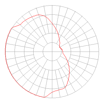
Directional Antenna
Antenna Make/Model: Jampro JSCP-6 RFR DA
Antenna ID: 71191
Polarization:
|
Structure Information
Structure Registration Number 1016110
[ASR Heights Differ from WPIR Application]
Structure Type: GTOWER
Registered To:
SBA Towers IV, LLC
Structure Address:
6546 Lovers Lane (va15061-a)
Warrenton, VA
County Name: Fauquier County
ASR Issued: 01/05/2024
Date Built: 10/01/1991
Site Elevation: 168.2 m (552 ft.)
Structure Height: 91.4 m (300 ft.)
Height Overall: 93.3 m (306 ft.)
Overall Height AMSL: 261.5 m (858 ft.)
FAA Determination: 07/31/2023
FAA Study #: 2022-AEA-16529-OE
Paint & Light FAA Chapters: A1, H, 3, 11, 21, 23
Continue As Is OM&L = A MED-DUAL SYSTEM
38-40-42.1 N 77-47-17.0 W (NAD 83)
38-40-41.7 N 77-47-18.0 W
(Converted to NAD 27)
|
WPIR(FM) Licensee Information
Positive Alternative Radio Inc.
P. O. Box 889
Blacksburg, VA 24063
| 20060327AIO Applicant Information
Edward A. Baker
Date: 03/27/2006
Application Certifier
Positive Alternative Radio, Inc.
P.O. Box 889
Blacksburg, VA 24063
Applicant
Elmer L. Steingass
2324 N. Cleveland-Massillon Road
P.O. Box 807
Bath, OH 44210-0807
Consulting Engineer
Cary S. Tepper, Esq.
Booth, Freret, Imlay & Tepper, P.C.
|