|
WVKR-FM
Call Sign History
WVKR-FM from 05/29/1981
WVKRFM from ???
|
91.3 MHz | 
|
Poughkeepsie, NY
|
|
WVKR-FM Channel: 217B1 91.3 MHz
Poughkeepsie, New York
Service: FM - A full-service FM station or application.
Facility ID: 69833
FRN: NO FRN
Fac. Service: FM
Status: LIC
Application Accepted: 08/16/1994
Application Granted: 03/28/1996
File Number: BLED-19940816KB
License Expires: 06/01/2030
Prefix Type: This is a license for a noncommercial educational FM station
Application Type: License To Cover
FCC Website Links:
LMS Facility Details
This Application
Other WVKR-FM Applications
Including Superseded Applications
Service Contour - Open Street Map or USGS Map (60 dBu)
Service Contour - KML / Google Earth (60 dBu)
Public Inspection Files
Facility Type: NON-COMMERCIAL EDUC. FM
Class: B1, A Zone I or I-A station; with 6kW-25kW ERP and a class contour distance 28km-39km
Site Location: 41-38-25.3 N 74-01-14.5 W (NAD 83)
Site Location: 41-38-25.0 N 74-01-16.0 W (Converted to NAD 27)
Effective Radiated Power: 3.7 kW Horiz. ; 0 kW Vert.
Antenna Center HAAT: 250 m Horiz.; 0 m Vert.
Antenna Center AMSL: 370 m Horiz.; 0 m Vert.
Antenna Center HAG: 70 m Horiz.; 0 m Vert.
Calculated Site Elevation: 300 m. (984 ft.)
Height Overall*: 77 m (253 ft.)
(* As Filed In This Application, may differ from ASR Data, Below.)
Directional Antenna
Antenna Make/Model: Oddball; usually designed by Applicant ODD880812MI
Antenna ID: 13890
Polarization:
|
Antenna Data for Antenna Id: 13890
WVKR-FM FM File: BLED-19940816KB
Oddball; usually designed by Applicant - ODD880812MI
Service: FM
|
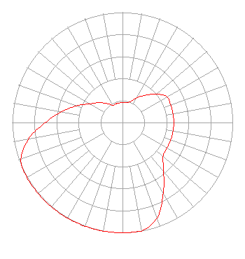 |
| Azimuth | Ratio | Azimuth | Ratio | Azimuth | Ratio | Azimuth | Ratio |
| 0 | 0.180 | 10 | 0.185 | 20 | 0.200 | 30 | 0.260 |
| 40 | 0.321 | 50 | 0.400 | 60 | 0.465 | 70 | 0.465 |
| 80 | 0.465 | 90 | 0.465 | 100 | 0.465 | 110 | 0.465 |
| 120 | 0.465 | 130 | 0.480 | 140 | 0.580 | 150 | 0.740 |
| 160 | 0.920 | 170 | 1.000 | 180 | 1.000 | 190 | 1.000 |
| 200 | 1.000 | 210 | 1.000 | 220 | 1.000 | 230 | 1.000 |
| 240 | 1.000 | 250 | 0.980 | 260 | 0.865 | 270 | 0.700 |
| 280 | 0.560 | 290 | 0.440 | 300 | 0.340 | 310 | 0.280 |
| 320 | 0.225 | 330 | 0.180 | 340 | 0.180 | 350 | 0.180 |
|
Structure Information
Structure Registration Number 1224519
[ASR Heights Differ from WVKR-FM Application]
Structure Type: GTOWER
Registered To:
American Towers LLC
Structure Address:
Mt. Zion Road (mt Zion #010330)
Marlborough, NY
County Name: Ulster County
ASR Issued: 08/11/2020
Date Built: 06/15/2005
Site Elevation: 299.6 m (983 ft.)
Structure Height: 79.6 m (261 ft.)
Height Overall: 80.8 m (265 ft.)
Overall Height AMSL: 380.4 m (1248 ft.)
FAA Determination: 07/20/2020
FAA Study #: 2020-AEA-7552-OE
FAA Circular #: 70/7460-1L
Paint & Light FAA Chapters: 4, 8, 12
PRIOR STUDY 2006-AEA-375-OE
41-38-27.4 N 74-01-15.2 W (NAD 83)
41-38-27.1 N 74-01-16.7 W
(Converted to NAD 27)
|
WVKR-FM Licensee Information
Vassar College
Poughkeepsie, NY 12604
Phone: 845-437-5475
Private Not-for-Profit Educational Institution | 19940816KB Applicant Information
Date: 08/16/1994
Application Certifier
Vassar College
Vassar College
P.O. Box 166
Poughkeepsie, NY 12601
Applicant
|
Associated Land Mobile Licenses
|
| (No Records Found) |
| Associated Microwave Licenses
|
| (No Records Found) |
|
