
FCCInfo.com
A Service of Cavell, Mertz & Associates, Inc.
(855) FCC-INFO
|
|
WRLB from 10/22/1981 |
|
|
|||||||||||||||||||
|
|
WRLB Channel: 237B1 95.3 MHz Rainelle, West Virginia Service: FM - A full-service FM station or application. Facility ID: 54410 Fac. Service: FM Status: LIC 73.215 Station Application Accepted: 05/13/2008 Application Granted: 06/09/2008 File Number: BMLH-20080513ABO Prefix Type: This is a modification of a license for a commecial FM station Application Type: Minor Modification FCC Website Links: LMS Facility Details This Application CDBS Application Other WRLB Applications Other WRLB Applications in CDBS Including Superseded Applications Mailing Address Correspondence for WRLB Correspondence related to application BMLH-20080513ABO Service Contour - Open Street Map or USGS Map (57 dBu) Service Contour - KML / Google Earth (57 dBu) Public Inspection Files History Cards for WRLB Facility Type: FM STATION Class: B1, A Zone I or I-A station; with 6kW-25kW ERP and a class contour distance 28km-39km Site Location: 37-57-28.4 N 80-45-44.3 W (NAD 83) Site Location: 37-57-28.0 N 80-45-45.0 W (Converted to NAD 27) Effective Radiated Power: 13 kW Transmitter Output Power: 4.8 kW Antenna Center HAAT: 139 m (456 ft.) Antenna Center AMSL: 991 m (3251 ft.) Antenna Center HAG: 52 m (171 ft.) Calculated Site Elevation: 939 m. (3081 ft.) Height Overall*: 63 m (207 ft.) (* As Filed In This Application, may differ from ASR Data, Below.) Directional Antenna Antenna Make/Model: Oddball; usually designed by Applicant ODD940503IZ Antenna ID: 14642 Polarization:
| |||||||||||||||||||||
| Antenna Data for Antenna Id: 14642 WRLB FM File: BMLH-20080513ABO Oddball; usually designed by Applicant - ODD940503IZ Service: FM | 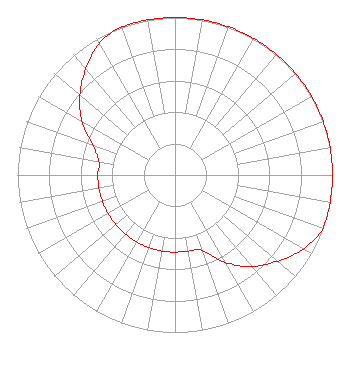 | |||||||||||||||||||||
| Azimuth | Ratio | Azimuth | Ratio | Azimuth | Ratio | Azimuth | Ratio | |||||||||||||||
| 0 | 1.000 | 10 | 1.000 | 20 | 1.000 | 30 | 1.000 | |||||||||||||||
| 40 | 1.000 | 50 | 1.000 | 60 | 1.000 | 70 | 1.000 | |||||||||||||||
| 80 | 1.000 | 90 | 1.000 | 100 | 1.000 | 110 | 1.000 | |||||||||||||||
| 120 | 0.940 | 130 | 0.850 | 140 | 0.760 | 150 | 0.640 | |||||||||||||||
| 160 | 0.510 | 170 | 0.490 | 180 | 0.490 | 190 | 0.490 | |||||||||||||||
| 200 | 0.490 | 210 | 0.490 | 220 | 0.490 | 230 | 0.490 | |||||||||||||||
| 240 | 0.490 | 250 | 0.490 | 260 | 0.490 | 270 | 0.490 | |||||||||||||||
| 280 | 0.490 | 290 | 0.557 | 300 | 0.682 | 310 | 0.788 | |||||||||||||||
| 320 | 0.880 | 330 | 0.964 | 340 | 1.000 | 350 | 1.000 | |||||||||||||||
Structure Registration Number 1038443 Structure Type: TOWER Registered To: Radio Greenbrier, LLC Structure Address: Simms Mountain Hwy 22 Rainelle, WV County Name: Greenbrier County ASR Issued: 04/17/2020 Date Built: 01/01/1974 Site Elevation: 938.8 m (3080 ft.) Structure Height: 52 m (171 ft.) Height Overall: 63.4 m (208 ft.) Overall Height AMSL: 1002.2 m (3288 ft.) FAA Determination: 11/20/1973 FAA Study #: 73-EA-1104-OE Paint & Light FAA Chapters: 1, 3, 11, 21 RED LIGHTS/PAINT 37-57-28.0 N 80-45-44.0 W (NAD 83) 37-57-27.6 N 80-45-44.7 W (Converted to NAD 27) |
9196 Seneca Trail South Ronceverte, WV 24970-8376 Phone: 304-645-1327 | Date: 05/13/2008 Application Certifier FAITH COMMUNICATIONS NETWORK, INC. P.o. Box 1727 Lewisburg, WV 24901 Applicant SCOTT C. CINNAMON Law Offices Of Scott C. Cinnamon, Pllc 1250 Connecticut Ave., Nw Suite 200, # 144 Washington, DC 20036 COMMUNICATIONS ATTORNEY SCOTT C. CINNAMON Law Offices Of Scott C. Cinnamon, Pllc | ||||||||||||||||||||
| ||||||||||||||||||||||