|
WBZO Channel: 253A 98.5 MHz
Westhampton, New York
Service: FM - A full-service FM station or application.
Facility ID: 57672
FRN: 0019034305
Fac. Service: FM
Status: LIC
73.215 Station
Application Accepted: 04/01/2004
Application Granted: 06/13/2006
File Number: BLH-20040401AKC
License Expires: 06/01/2030
Prefix Type: This is a license for a commercial FM station
Application Type: Amendment
FCC Website Links:
LMS Facility Details
This Application
Other WBZO Applications
Including Superseded Applications
Service Contour - Open Street Map or USGS Map (60 dBu)
Service Contour - KML / Google Earth (60 dBu)
Public Inspection Files
Facility Type: FM STATION
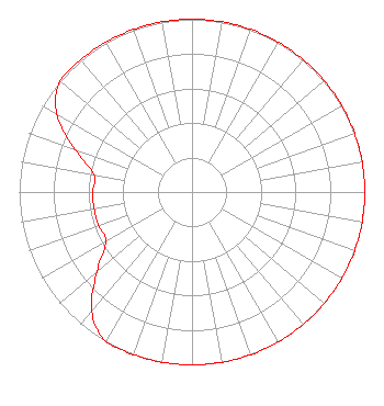
Class: A, A Zone I; I-A; or II station; with 0.1kW-6kW ERP and a class contour distance <=28km
Site Location: 40-51-18.4 N 72-46-09.4 W (NAD 83)
Site Location: 40-51-18.0 N 72-46-11.0 W (Converted to NAD 27)
Effective Radiated Power: 0.95 kW
Transmitter Output Power: 1.15 kW
Antenna Center HAAT: 160 m (525 ft.)
Antenna Center AMSL: 174 m (571 ft.)
Antenna Center HAG: 100 m (328 ft.)
Site Elevation: 74.3 m. (244 ft.)
Height Overall*: 155.4 m (510 ft.)
(* As Filed In This Application, may differ from ASR Data, Below.)
Directional Antenna
Antenna Make/Model: Electronics Research Inc. LP-2E-DA-HW, two sections, .5 wavelength spacing
Antenna ID: 64720
Polarization:
|
Structure Information
Structure Registration Number 1004116
[ASR Heights Differ from WBZO Application]
Structure Type: GTOWER
Registered To:
SBA Properties, LLC
Structure Address:
Cr111 & Eastport Manor Rd (ny00467-a)
Manorville, NY
County Name: Suffolk County
ASR Issued: 07/23/2025
Date Built: 07/01/1998
Site Elevation: 74.4 m (244 ft.)
Structure Height: 155.4 m (510 ft.)
Height Overall: 159.1 m (522 ft.)
Overall Height AMSL: 233.5 m (766 ft.)
FAA Determination: 07/16/2025
FAA Study #: 2025-AEA-5800-OE
FAA Circular #: 70/7460-1M
Paint & Light FAA Chapters: 4, 8, 15
PRIOR STUDY 2022-AEA-242-OE
40-51-18.2 N 72-46-09.0 W (NAD 83)
40-51-17.8 N 72-46-10.6 W
(Converted to NAD 27)
|
WBZO(FM) Licensee Information
JVC Media LLC, A Florida LLC Company
2301 Lucien Way
Maitland, FL 32751
Phone: 631-648-2500
Corporation | 20040401AKC Applicant Information
John Caracciolo
Date: 04/01/2004
Application Certifier
Jarad Broadcasting Company of Westhampton, Inc.
1103 Stewart Avenue
Garden City, NY 11530
Applicant
John Caracciolo
1103 Stewart Ave
Garden City, NY 11530
President, Director of Engineering
Lewis J. Paper
Dickstein Shapiro Morin & Oshinsky LLP
|